
I find it unfortunate that the uproar over Bylaw 526.8 is threatening to obscure the potential benefit to Hudson from the data being surfaced by urban planner Eco2Urb.
In June, council approved Eco2Urb’s hiring on the basis of the following conditions:
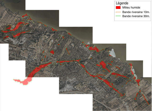
— It would update and confirm data contained in the 2008 Teknika HBA wetland and woodland audit;
— It would fill in the blanks in the 2016 CIMA+ conservation plan for Hudson’s urban perimeter (the 48% of the town already zoned for development);
— Like Teknika and CIMA+, Eco2Urb would then rank these natural spaces in terms of conservation priorities that could be incorporated in a revised master plan.
Under political pressure from Hudson’s anti-development lobby, council added a fourth ask — that Eco2Urb provide a scientific basis for the tripling of the province’s 10-metre buffer zone around Hudson’s extensive wetlands.
For $89,367.50 plus taxes, Eco2Urb’s team would apply the same conservation template to Hudson that it had developed for St. Lazare. Roughly $20,000 of that was for workshops where everything would be explained to council and citizens.
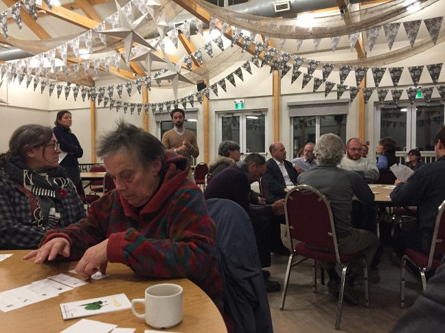
Last Monday (Nov. 11) was the public workshop. Leaving out the mayor and five councillors, fewer than two dozen Hudson residents turned out, possibly because of the season’s first blizzard. Whatever the reason, the net result is that residents won’t have the benefit of understanding how and why Hudson should go about protecting its wetlands and woodlands as our region comes under increasing pressure to develop.
I wonder whether the turnout would have been greater if residents were told Eco2Urb’s data will allow allow a lot-by-lot identification of possible environmental constraints — and that eventually, this information will be available to developers, property owners and real estate agents. (No, Hudson doesn’t need Bylaw 526.8.)
There were three tables. I was at a table with the mayor and several residents of Wilkinson, a street in Como where a number of properties back on the wetland running through the proposed Willowbrook development as well as to the rear of Oakfields. Once they heard their properties could be affected, even those in favour of protecting wetlands and woodlots tended to back off when they realized the resale value of their properties could be affected.
The next table over featured councillors Robinson and Rikley-Krindle, plus members of the mayor’s Environmental Action Group, or as one observer remarked, the NIMBYs (Not In My Back Yard) and the NOPEs (Not on Planet Earth). The third table included councillors Kurgansky and Legault as well as West End property owners.
Eco2Urb’s Kyle Teixeira-Martins and his facilitators set up the exercise by explaining how they propose to rank Hudson’s wetlands and woodlands according to six ecological yardsticks — resilience, biodiversity, connectivity, forest maturity, flood mitigation and recreational/historical importance. We were then asked to rank the six metrics in order of importance.
— Resilience is the measure of a natural area’s ability to recover from insect invasion, disease, drought or flooding.
— Biodiversity is the sum of the trees and animals found in a natural area.
— Connectivity is the measure of an area’s attractiveness as a habitat and migration corridor for vertebrate species.
— Forest maturity ranks forests according to their age. A young forest is zero to 40 years, an intermediate forest 40-80 years and mature, 80+. A mix of all ages is the target balance.
— Flood mitigation is the potential of an area to act as a buffer against the impacts of flooding.
— Recreational and historical importance is a natural area’s importance for citizens and visitors, either because it offers recreational possibilities or is of historical interest.
The second exercise asked us to rank six woodlots according to their ecological value as measured by the yardsticks above. Although nothing was identified by name, the sites of the Willowbrook and Sandy Beach developments were included, making dispassionate discussion difficult.
While the evening was instructive, the best demonstration of the problems we face in ranking conservation areas came from Pyke Court resident Adrian Burke. Burke told the room he wanted no part in ranking forests and wetlands. Instead, he said, the data developed by Eco2Urb can be used to identify environmental constraints on a lot-by-lot basis.
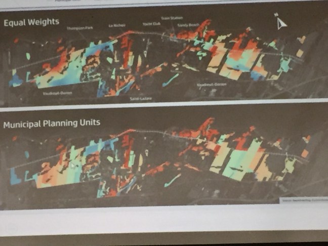
Later, Burke provided council with a technical explanation of how the GIS software Eco2Urb employs allows urban planners to click on an an interactive map to access information generated by Eco2Urb. Eventually, anyone with access to the database will be able to reference possible constraints to development for that particular lot or sector.
Burke also offered advice on how the town can use Eco2Urb to move forward without the need for politically fraught decisions on rankings, moratoriums and blanket bans:
— Have Eco2Urb supply the colour-coded ‘heat maps’ as well as all the mapping software data in an easily accessible, searchable form;
— Colour-coded maps will be useful and complementary, but only if used with the database.
— Ask Eco2Urb to train urban planning in their use;
— It is easy to create maps from the Eco2Urb GIS layers that can be opened and explored using GoogleEarth. These maps should be made available online on the city portal for all residents to consult and use.
This was the real benefit of Monday’s workshop. It got everyone thinking past the need for a blanket ban on land use within 100 feet of wetlands. It showed how the town can harness the technology that cost us $100,000 to accomplish what council set out to do. If we don’t seize the opportunity, this council will have failed at one of its core missions.
Controlling factors
Following Monday’s workshop, I compiled a list of the factors both within and beyond Hudson’s control that will drive development for the foreseeable future.
I’m sure there are many others that I have missed.
— Planning imposed on us by the Montreal Metropolitan Community and our regional government has frozen the dezoning of agricultural land. Their goal: reduce urban sprawl and concentrate development in sectors already supplied with roads, drinking water, sewers, public transit, schools and businesses. To accomplish this, MMC and MRC bureaucrats have set non-negotiable densification targets for serviced sectors.
— With less and less land available within these urban perimeters, developers are turning to marginal sites on the edges of wetlands and floodplains. Quebec insists on a mandatory 10-metre minimum buffer zone to protect from people landscaping to the edge of their properties, then dumping lawn waste and other detritus into the protected zone.
— 52% of Hudson’s lands are zoned agricultural, but that doesn’t mean they’re immune to human activity that will degrade their ecological value. Owners of agricultural lands can clearcut mature forest except for 10-metre buffers along watercourses and wetlands. They can strip-mine peat bogs. They can drain and backfill wetlands. They can build houses for themselves, family members and employees.
— Hudson’s lack of control over what goes on upstream. Development in Vaudreuil-Dorion and St. Lazare is already affecting us in the velocity and volume of stormwater making its way into Viviry Creek and its tributaries. Development in Hudson has an even more immediate effect on water quality along our Ottawa River shoreline.
— Growing pressure on Hudson’s administration from developers to set a clear, coherent development policy. One is Nicanco, the owners of Sandy Beach. The previous administration signed an October 2017 agreement with Nicanco approving their 256-door development; its partners sought clear signals from this council whether we would honour the 2017 development agreement. Willowbrook, the other major development approved by the previous council, asked for and received the town’s support for an application to the environment ministry to construct roads, a bridge and drainage infrastructure. It’s hard to get lawyers to agree on much, but lawyers have agreed that the lack of a clear, coherent development policy will end up costing Hudson considerably in legal expenses.
— Quebec legislation gives municipalities the right to say no to development, but it’s not that clear-cut. Jurisprudence — the body of legal decisions on the topic — cuts both ways. Changes to municipal legislation adopted this summer have given towns like Hudson added powers over development, including the ability to freeze new projects while their councils decide what direction future development should take.
— The emergence of popular initiatives opposed to generally accepted practices used by developers — clearcutting, draining, backfilling, levelling. Hudson is widely known among developers as a hard place to do business, especially so for multi-unit projects. At present Hudson has no mechanism to reconcile the right to ownership of private property with the rights of those opposed.
— Our vulnerability to changes to the aquifer that supplies Hudson and most of Vaudreuil-Soulanges with drinking water. Blind faith isn’t going to cancel out the cumulative effects of faster runoff, smaller and fewer retention areas on the aquifer’s ability to replenish itself. Sooner or later, there won’t be enough wetland left to capture the precipitation essential to a sustainable water supply. Joint stewardship is the only path forward, but our MRC refuses to take a leading role. So we must.
