Minutes before the mayor arrived at Hudson’s Stephen F. Shaar Community Centre to open the May 26 council meeting, those present witnessed a blatant violation of the town’s month-old code of ethics and good conduct for elected municipal officers.
Witnesses to the outburst included fellow councillors as well as the town’s director-general and assistant town clerk, plus a handful of citizens. Also left open-mouthed was the CSUR video recording crew waiting for Mayor Chloe Hutchison to call the meeting to order before starting the live online feed.
Still unclear is what triggered the councillor’s explosion. He had just taken his seat when he was approached by a resident of his district who wondered when they could schedule an appointment to discuss a neighbourhood drainage issue cited by the town as the reason why the street can’t be repaved.
The councillor was the only one raising his voice. He was busy. Too busy to call, too busy to reschedule. Get out of my face. You’re disturbing my vibe. It was one of those moments that gets posted on social media if someone has the presence of mind to hit record on their phone.
Here’s the kicker: Bylaw 781-2026 Code of Ethics and Good Conduct for Elected Municipal Officers of the Town of Hudson was adopted unanimously at the April 28 meeting. In this case, the focus is on Section 4.3 Respect and civility for other members, municipal employees and citizens:
More specifically, each Council member must:
• Demonstrate civility and courtesy in all interactions and communications, including those on the web and social media;
• Respect the dignity and honour of fellow Council members, muncipal employees and citizens.
The resident filed an official complaint under Bylaw 781. The clerk’s office acknowledged receipt but under Bylaw 781’s Section 15 —Control Mechanisms, disciplinary action — if any — will remain behind closed doors.
Sanctions start with a reprimand and range from participation in a professional development program on municipal ethics and good conduct at the Council member’s expense, to a fine or suspension.
But nowhere is there a mention of a simple apology.
Always instructive and ofttimes surprising, those videos of missed Hudson council meetings…
Remember last year’s heated discussion over whether the town should accept a $2 million grant from the Montreal Metropolitan Community toward the Sandy Beach purchase?
Some may recall last month’s Survey Monkey poll, with the current council telling taxpayers it was inclined to accept the subsidy even if it meant Hudson taxpayers would have no more right to enjoy the beach than the MCC’s 4.4 million other residents.
As Mayor Chloe Hutchison told a handful of residents at the start of the Feb. 24 meeting, the 560 respondents to the Monkey survey were split 50/50 on whether to accept or reject the MCC.
So how did council vote?
The five — minus an absent District 3 councillor Peter Mate, but more on that later — voted unanimously for the CMM cash. In moving the resolution, District 5 councillor Mark Gray said it was to ease the burden on taxpayers, which as I noted in my Feb. 13 thousandlashes.ca post, ostensibly amounts to $37 per year per unit. Ostensibly, because neither the loan bylaw for the purchase nor the 2026 taxes and tariffs bylaw back up a $127-per-unit verbal estimate released at last August’s public consultation.
The only confirmation of any of these numbers is contained in an internal document called a fiche de règlement d’emprunt, or loan settlement request, filed by the town’s acting treasurer with the municipal affairs ministry in late September. The doc commits the municipality to the total amount of the loan bylaw — $9,648,136, reduced by $2 million from the town’s unallocated surplus. (No mention here of CMM’s subsidy.)
The remaining $7,648,136 will be paid over 40 years at an interest rate of 3.10%. The annual debt service charge: $336,246, split equally among 2,785 units as defined in loan Bylaw 782-2025.
But none of this comes into effect until the Sandy Beach deal is signed with the sellers. As Hutchison explained, a resolution on that evening’s agenda — Bylaw 770.1.2026 modifying Bylaw 770 2024 on the use of the Sandy Beach Nature Park and Beach — was deferred to allow the vendors to make changes to their corporate governance to reflect the death of Nicanco’s founder Hans Muhlegg. Two more weeks, she predicted, with a tentative March 18 handover.
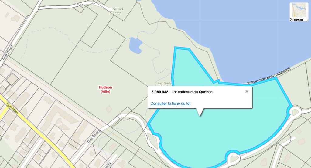
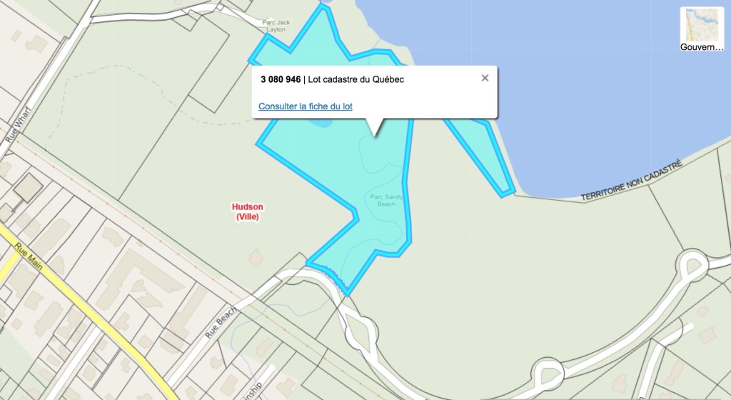
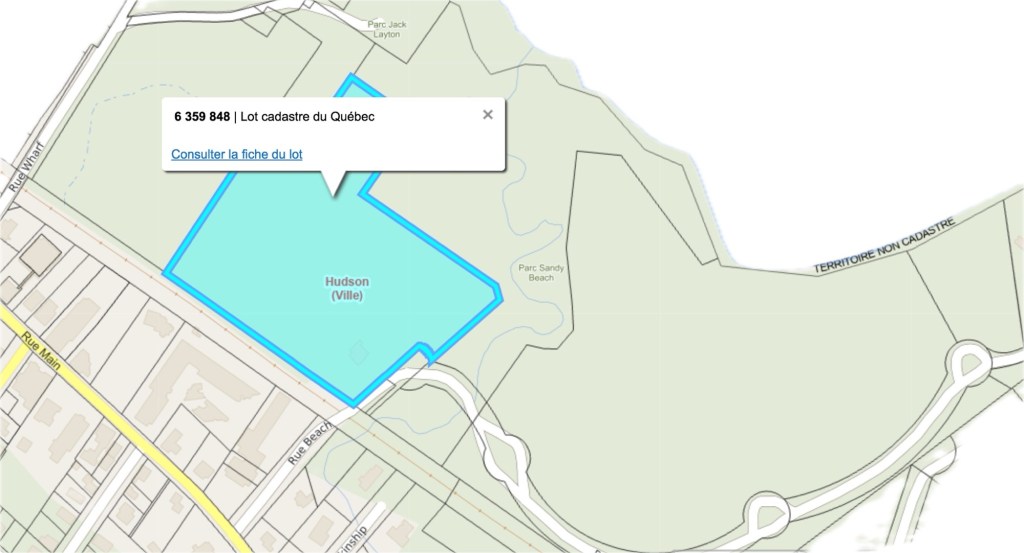
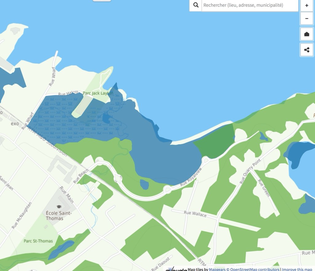
Council has yet to explain what exactly is being changed in this revised bylaw, and why. The 2024 resolution granted public access to “Sandy Beach Nature Park” without further definition. The revision redefines Sandy Beach Nature Park as the area made up of lots 3 080 946, 3 080 948 and 6 359 848. (For a better idea of what this constitutes, I have used the government’s Infolot site to isolate the three cadasters.)
The confusion arises with Gray’s resolution, which made it clear the town’s intention is to put the $2M toward the purchase of all seven lots, thereby opening their use to all MCC residents. So how can the four remaining lots listed in loan Bylaw 782-2025 not be part of the Sandy Beach Nature Park?
Nor was there much light shed on the hiring of the non-profit Nature-Action Quebec to draft a Sandy Beach Nature Park management and conservation plan. Is the $46,840 tab included in the $9,648,136 loan bylaw, or will this and other expenses incurred as part of the Sandy Beach acquisition be treated as operating expenses?
&&&&&&
Council’s spending priorities were questioned by Cameron resident Jeff Gauthier, who took the mic during the first question period to follow up on a near-fatal accident on Cameron early in the New Year. A friend suffered life-changing injuries after being struck by a pickup truck while walking on the pedestrian path and Gauthier has been pushing the administration to commit to making Hudson’s streets safer.
In a Jan. 16 letter to the mayor and District 4 Councillor Reid Thompson, Gauthier described how he has written Thompson in the past regarding the danger to pedestrians from speeders on Cameron. The town’s solution: speed radars to remind speeding drivers how fast they’re going.
“Today it has hit home personally in that one of my very good friends has been struck by a vehicle on Cameron,” Gauthier’s letter continued.”The details are unknown at this time as the gentleman is in hospital with very serious injuries.
Gauthier’s letter concludes: “With all the projects than have been approved by the town council and yourself this last year costing millions of our dollars, it would be unfair to citizens…if there are no serious changes projected for Cameron […] and other traffic security issues, eg, Cote St. Charles.”
In his followup comments to council, Gauthier listed traffic-mitigation measures such lane-separation bollards, better snow-clearing and vegetation trimming as well as the use of the town-owned 17-metre setback at the steepest part of Cameron for a separate pedestrian/cycling path.
Hutchison refused to be drawn into a debate. “There have been multitudes of safety requests,” she replied. A separate pedestrian path on Cameron would cost the town two thirds of Hudson’s annual paving budget and it’s not there for 2026, she went on. Council’s plan? A macro master plan on mobility, “coming to the table soon.”
&&&&&&&
The mayor didn’t dwell on the abrupt resignation of District 3 councillor Peter Mate, other than to announce a byelection Sunday, May 3. Mate, elected by acclamation less than five months ago, resigned both as councillor and town planning advisory committee chair Feb. 3, the day before the monthly TPAC meeting.
Now that we’ve read the text of the proposed $9.6M loan bylaw to buy out the owners of Sandy Beach, I’ll repeat the questions I asked at the Sept. 11 special meeting where the notice of motion and tabling of draft were approved unanimously. (Final adoption of the loan bylaw is scheduled for another special meeting this evening.)
Can council guarantee taxpayers will be able to afford this purchase?
Even those passionately in favour of the Sandy Beach buyout have voiced their concerns over the lack of financial details. The text of Bylaw 782-2025 doesn’t address those concerns. Most of it is a lengthy preamble, citing studies, reports and legal actions taken in the 25-year history of the proposed residential development.
Financial details are as follows:
— The Town and owners of the land have reached agreement on the sale of seven lots comprising the proposed development for $8,750,000, excluding taxes and costs. The town does not have the necessary funds to acquire the lots.
— The draft bylaw authorizes council to spend the sum of $9,648,136, including incidental expenses and net taxes, $2M of which will come from the town’s unallocated surplus. An additional $2M grant from the Montreal Metropolitan Community (CMM) remains a possibility. (“We want to keep that door open,” mayor Chloe Hutchison told residents at the Sept. 11 meeting.)
— The remaining $7,648,136 will come from a loan, which like all municipal borrowing requires the approval of taxpayers and the provincial municipal affairs ministry as well as a five-year rollover structure based on prevailing interest rates.
— Borrowing and repayment costs will be charged to the owner of every taxable immovable in Hudson for every unit they own. The bylaw defines a suite thus: serving or intended to serve as a residence for one or more person and where one can prepare or consume meals, sleep and includes a sanitary facility. It may be occupied by either an owner-occupant or rented.
The only exclusion are bi-generational accessory dwellings occupied by or destined to be occupied exclusively for persons having a family, marital or common-law relationship to the second degree with the occupants of the main housing unit.
Commercially, a unit is defined is defined as a space accommodating or intending to accommodate commercial, industrial or craft activities such as the sale of goods or services, either owned by an owner-occupant or rented.
When asked how the per-unit assessment would affect the Manoir Cavagnal and its 90-something units, the mayor said the administration was working on it. A similar response dealt with questions about the cost of securing the beachfront and adjacent forests once it’s open to the general public.
Residents attending the Aug. 27 information meeting were told the term of the loan will be spread over 40 years to minimize the fiscal impact on taxpayers. Although the figure of $121 per unit was given at the Aug. 27 session, the draft loan bylaw doesn’t provide a number. Instead, it entertains the possibility of that $2M grant from the CMM (reducing the annual cost per unit by $35) with the proviso that any “contribution, donation and subsidy” will be used to reduce the loan or defray debt servicing costs.
Simply put, the draft bylaw holds out the hope that federal, provincial or regional governments and NGOs such as Save Sandy Beach will ride to the town’s financial rescue if the tax burden becomes more than Hudson taxpayers can stand.
What the bylaw doesn’t include is the real cost of borrowing $7,648,136 based on a 40-year amortization schedule with five-year resets. Based on an average interest rate of 3.25% for the entire 40-year term, the total cost to taxpayers would be $13.71M, with $6.06M of that in debt interest.
How will it affect the Town of Hudson’s long-term debt? For that, residents can turn to fiscal consultant RCGT’s Cadre financier 2025-2030, an analysisof Hudson’s fiscal roadmap for the next five years.
The RCGT portrait begins with revenues ($14.1M in 2025), more that 80% of it generated by property taxes. Revenues are projected to grow by an average of 4.8% annually, reaching $17.8M by 2030. Most of that growth is generated by real estate transfer taxes, which the town tends to underbudget as a guarantee that Hudson’s annual budgets generate surpluses instead of deficits.
RCGT predicts an average annual budget increase of 4.4% to $21.9M in 2030.
Meanwhile, Hudson’s net debt will reverse a decade-long reduction trend, rising from $22.4M in 2025 to $41M in 2030, a 13.8% increase representing 16% of the 2030 budget — an annual jump of 9.4%. Debt service charges will grow by 10.6% and the debt/revenue ratio ranging between 120% and 155% as the town incurs new debt faster than it can write off old debt.
To soften the annual hit, RCGT advised the town to extend the Sandy Beach loan to 40 years from 30 and to delay construction of a new town hall by two years (2028 instead of 2026) and delaying major reconstruction of a portion of Lower Alstonvale now that preliminary studies show it wasn’t as far gone as first feared.
RCGT predicts Hudson’s debt servicing charges will remain stable through 2027, increasing to $3.6M in 2030 as the town incurs the costs of a new municipal garage and the repaving of Main between Beach and Quarry Point.
Even so, the cost of servicing Hudson’s long-term debt will increase by a third, from $2.2M in 2025 to $3.3M in 2030 — representing 16% of the town’s total 2030 budget.
Asked at the Aug. 27 public information meeting what constraints Quebec might place on Hudson’s long-term debt, RCGT’s Nicolas Plante told the room it was up to taxpayers, not the government.
Here’s my translation of RCGT’s conclusion:
“With a 40-year amortization period, the additional debt related to the Sandy Beach acquisition does not have a significant impact on the debt service ratio in 2030. However, the level of the debt balance increases, and the net debt-to-revenue ratio reaches 166% in 2030.
With this in mind, the City should adopt certain guidelines to control its debt level, such as prioritizing projects (by limiting the maximum borrowing amount per year), using future surpluses to prepay or avoid debt, or implementing a cash payment program for capital assets. These measures will enable the City to maintain an adequate level of debt in line with the challenges of renewing its assets.”
Does any of this matter to Hudson residents? We won’t know until the evening of Wednesday, Sept. 24, the one-day register for those opposed to the bylaw. A referendum would require at least 491 signatures on the register.
Is there a viable opposition? Not from potential mayoral candidates I’ve spoken to. Residents venturing an opinion say they’re of two minds — glad to see an end to a 25-year squabble over plans to develop the 60-acre parcel, concerned by the impact of the loan bylaw on the town’s finances and the lack of clarity on how the town proposes to manage the acquistion.
A big concern is whether the Sandy Beach purchase will tie the hands of future councils. With a 30% increase in Hudson’s long-term debt by 2030 and a 33% hike in debt servicing costs, it’s easy to see how the town might find itself strapped for cash for emergency expenditures, such as replacing a major artery washed away by torrential rains.
One of the presentations at the Aug. 27 info session was how tax revenues generated by Empero’s proposed Pine Beach development would offset Hudson’s growing debt/tax revenue ratio and help pay for future capital works projects. It was dismissed without discussion. The current council has not shown itself interested in densifying the urban perimeter despite threats by the federal and provincial governments to withold funding.
Instead of looking at ways to grow Hudson’s tax base, the current council has spent the past four years looking for legal ways to block Empero’s June 2020 proposal to build 214 residential units on the 24-hectare parcel of land between Jack Layton Park and Quarry Point.
Originally approved as a zoning change by 72% of those who voted in October 2001 referendum, the project has evolved over the years as the result of changes to provincial and regional environmental protection laws and regulations.
Notwithstanding this council’s use of development freezes and bylaw revisions, the town’s legal advice was that the province and the courts will recognize the owners’ right to develop — and to block public access to the town’s beachfront servitude. Mayor Hutchison was left with difficult choices — get Quebec’s approval for new lakefront access or shut down the beach and trail network for the time it took to cut a deal with owners Nicanco Inc. and their partners.
The momentum to buy out the developer began with the August 18 special meeting, where council voted unanimously to authorize town clerk Melissa Legault to sign an offer to purchase seven lots from their current owners for $8.75 million plus taxes. Unlike regular council meetings, the special was not streamed online.
This was where Hutchison told residents a loan bylaw was the fairest way to spread the cost, with $2 million from the town’s accumulated surplus and another $2 million available from the Montreal Metropolitan Community, conditional on equal access to all Greater Montreal residents. Instead of being collected as a membership or assessed by mil rate, a fixed cost per address would present as a line item on tax bills.
This was where we learned the bylaw would be subject to approval by referendum, depending on whether at least 491 eligible residents signed a Sept. 24 registry. There would be an August 27 public information session, where the mayor promised a “respectful, fact-based” process.
The buildup to the Aug. 27 info session included a card in the mail, urging residents to reserve seats if they planned to attend in person where they would learn how the purchase will be financed, its impact on property taxes, conservation and community benefits and the steps in the approval process.
Those who managed to book seats were handed Save Sandy Beach pamphlets at the door to the Community Centre, where it became clear most of the 250 in attendance were there to celebrate their long-awaited victory rather than to ask probing questions about the financials and explore alternatives. A video loop featured drone footage of the beach, the Viviry Creek estuary, wetlands and forests — most of it land already ceded to or controlled by the town. The evening’s introductory slide was entitled Conservation and Access to River’s Edge, setting up the current administration’s contention that those 60 acres can somehow be protected while open to all.
But it became obvious from the outset that even if they are not mutually exclusive, there must be limits. This emerged during citizen exchanges with Nicolas Milot, the CMM’s director of ecological transition, who later explained that if the town were to accept the $2M MCC grant, all four million of its residents would enjoy the same access as Hudson residents — including the beach.
The mayor set up the financial discussion with a more precise cost to taxpayers —$9.6 million, taxes in — and the results of an October 2024 assessment of the land’s market value by real estate assessors LB (you’ll find this and other supporting docs on town website).
LB’s assessment set a fair market value by setting a realistic price per unit, based on the developer’s 2020 plan for 214 units — reduced by subsequent floodplain maps — and other real estate projects such as St. Lazare’s Place du Parc and high-end residential development on Mont Rigaud. It also considers the cost of constraints — interim control measures instituted by Hudson and the MCC, acreage listed on the province’s contaminated-soil register, contested bans on wetland backfilling and treecutting. LB’s final tally of projected profits: $11.5M for the 214-unit 2020 plan, $10M with all those constraints.
Earlier this year, the town made the owners a lowball offer of $5.5M. It was refused, but the partners countered with the $8.75M response. Why were they ready to sell for so far below market value?
Among the supporting documents is a draft transaction discharge signed this past August 15 by all parties. Once the sale becomes final sometime next year, the discharge ends all legal constraints and seemingly endless litigation by both sides. If the bylaw drive fails at any point in the process, if this council is voted out of office and the deal is killed by the next council, everything reverts to the standoff which has existed for the past 25 years. LB uses the term “best and most profitable usage” to describe any path out of this quagmire. If ever there was such a thing as a legal document with emotion, this is it. They want the endless war to end.
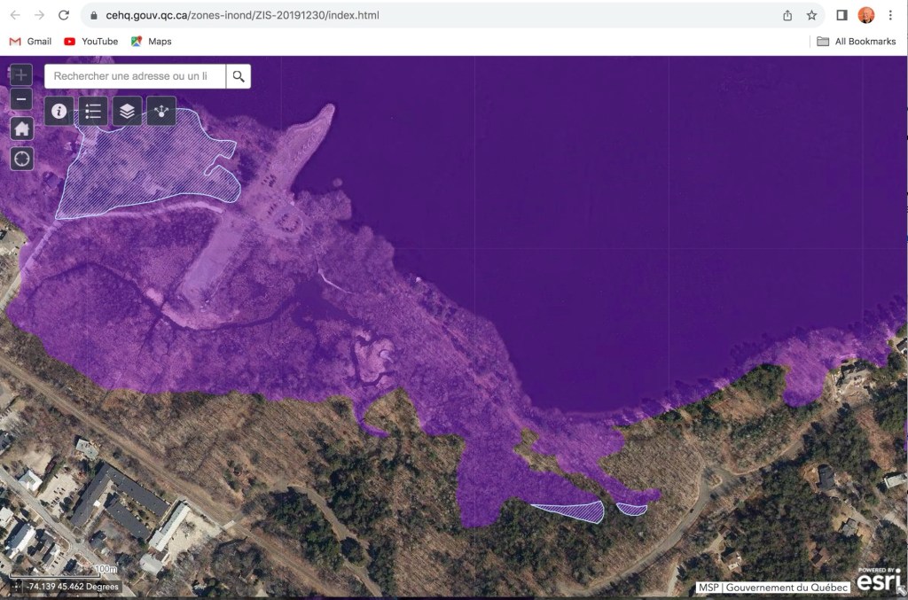
More than half of Hudson’s $10M Sandy Beach purchase falls within this environment ministry map of the 2019 floods. So why did the town’s loan bylaw documentation claim it falls outside?
Hudson’s current management is again resorting to Survey Monkey in an attempt to build a consensus in favour of accepting a $2M government grant — with strings attached — to lower the cost to taxpayers of the Sandy Beach acquisition.
Hudsonites may recall how the SM polling app was last used to build support for changes to urban planning bylaws that would have, among other things, taxed property owners for renovations. The aim — to generate revenue for greenspace acquisition — didn’t sway irate residents, many of whom saw it a blatant tax grab. Mayor Chloe Hutchison and her council backed off far enough to appease most complainants.
The Monkey’s return raises hard questions about why the Montreal Metropolitan Community’s $2 million subsidy offer is suddenly a priority. The preamble to the opinion survey (found on the town website) tells us “Council is currently inclined to accept the $2-million CMM Trame verte et bleue grant to help reduce the cost of acquiring Sandy Beach for taxpayers.”
But we’re not talking about major savings per household — $37 per year over loan bylaw 782’s 40-year lifespan. Is a $37 annual savings per household worth losing control of who can access an ecosystem described by Teknika, Cima+ and Eco2Urb biologists as the one most in need of protection?
Even Save Sandy Beachers attending last August’s public information session raised concerns about the potential costs of taking the CMM’s money. Nicolas Milot, the CMM’s director of ecological transition, explained then that if the town accepts the grant, anything the money is used for must be equally accessible to all 4.3 million CMM inhabitants — close to half of Quebec’s entire population. There was no rush, Milot reassured the audience — the town had until March 2026 to make up its mind.
Now, with barely two weeks until the March deadline, what factors could be pushing council’s agenda in favour of accepting the CMM grant?
— Unrealistic borrowing costs. According to the Loan Settlement Request (LSR), an internal document filed with the municipal affairs ministry in late September, Hudson has Quebec’s permission to borrow $7,648,136, payable over 40 years at an interest rate of 3.10%. Estimated annual cost: $336,246, shared equally between 2,785 units. That works out to $120.73 per unit, although you won’t find that number anywhere in the loan bylaw.
(Loan Bylaw 782 defines a unit as a residence, residential/commercial rental space —occupied or not — or unbuilt cadaster, regardless of size, frontage or assessed value.)
What are the chances of a Quebec municipality being able to depend on a 3.10% interest rate for the duration of a 40-year loan? Here’s a ChatGPT summary:
Current market benchmarks for long-term public debt in Canada are above 3.10 %, generally closer to 3.5–3.9 %.
Municipal borrowing costs usually include a spread over those benchmarks, implying that locking in a 40-year fixed rate of ~3.10 % outright would be relatively uncommon at this time.
Over a full 40-year average across multiple interest environments and refinancing events, a ~3.10 % average is possible but would require extended periods of low rates relative to current long-term levels.
— Surplus mismanagement? The LSR locks the municipality into appropriating $2M from the town’s unallocated surplus to cover the spread between the $9.6M bill of sale and the $7.6M loan bylaw. It could have doubled that, reducing the debt burden on taxpayers by the same $37 as the CMM subsidy. The document makes it clear why the administration didn’t double the transfer from the surplus: it would have reduced the town’s borrowing capacity for a new public works building, town hall and a growing list of infrastructure imperatives contained in this administration’s 2026-28 capital investment plan.
— Assessment error? The LSR raises the possibility that the town overpaid for unbuildable wetland by ticking the Yes box to the following question:
Following the Spring 2019 flooding, the Quebec government decreed a ZIS (special intervention zone). Does the object of the loan bylaw fall entirely outside ZIS territory?
The environment ministry’s own map of the 2019 flooding shows at least half of the entire Sandy Beach acquisition falling within the floodplain. Is it outside Quebec’s latest maps?
— Is this council banking on additional funding, either from the CMM or other sources as suggested in Section 8 of Loan Bylaw 782-2025?
Council shall allocate to the reduction of the loan decreed by this By-Law any contribution, donation, and subsidy that may be paid to it for the payment of part or all of the expenditure decreed by this By-Law.
Council also allocates any subsidy payable over several years to the payment of part or all of the debt service. The repayment term of the loan corresponding to the amount of the subsidy will be automatically adjusted to the period set for the payment of the subsidy.
Like the preceding extract, the Survey Monkey blurb is a masterpiece of wishful thinking and good intentions, culminating in this gem:
“The agreement is to ensure financial compliance, not political or operational control.”
This administration attempts to present acceptance of the CMM subsidy as a fiscal measure. In the absence of a promised conservation and management program, it threatens to become an unbudgeted exercise in controlling access to one of the very few free public beaches in the Greater Montreal region, home to more than 4 million people.
Once that CMM grant is in the town’s hands, beach access is no longer a matter of regulating usage. It becomes an as-yet-unresolved public security issue. Unless it bars all public access to Sandy Beach pending a conservation and management program, the administration will be powerless to prevent unauthorized uses such as illegal fires, swimming and off-leash dog activities.
In this context, Hudson’s taxpayers will spend the next 40 years paying for an amenity to which they no longer have access. In a transparent world, Mayor Hutchison and her council should have found a more democratic means of measuring how residents feel about accepting the CMM subsidy. Time to get this Monkey off our backs.
I wrote this a year ago. Amazing, the change since PM Mark Carney’s election.
A longtime friend, now part of Ottawa’s diplomatic community, married into a family of lawyers with an established practise in a central Mexican city. Life was good until the family was approached by an underworld cartel looking to acquire a property the family owned.
It might be for sale, the family said.
No, we don’t wish to buy it, was the response. You will sign it over to us for nothing. The ‘or else’ didn’t need saying.
At first their targets ignored the extortionists. But the threats (including photos of my friend and her infant daughter) escalated to the point that the young familt decided to flee — first to an American border city where they knew they wouldn’t be safe — and then to Canada,
I was reminded of their story by Trump’s rantings to the Davos crowd vis-a-vis Canada becoming the 51st state. There’s no distinction to be made between #47 and a Mexican cartel boss. “Nice little country you got here…a shame if something would happen to it.”
Like that Mexican family, the initial reaction is one of indignation. Greenland, the Panama Canal or Canada aren’t for sale. But the threats continue, the hostility ramped up. Anxiety builds among those targeted. But unlike my friends, there’s no escaping to a safe haven.
Canada isn’t dealing well with Trump’s megalomania, but I don’t suppose anyone else is. A big problem is the power-sharing agreement between Ottawa and the provinces. Gray areas abound on the jurisdictional map. Energy was a federal competency; it has been steadily eroded by provincial pressure depending on whether it involves fossil fuels, electricity or nuclear — or whether it’s a have or have-not province in the Canadian interprovincial wealth-transfer system, with or without a carbon-compensation structure. Regardless of which political party wins the spring federal election, the winners will get to work with a gridlocked confederation crippled by interprovincial trade barriers and jurisdictional spats.
…which brings me back to bhow best to deal with Trump. Is he corruptible, ready to drop this lunacy if the price is right? Or should Canada address the list of pretexts Trump plopped in front of Justin Trudeau at that Mar-a-Largo dinner? Trumpian grievance creep is notorious; what was a GDP two-percent NATO contribution in Trump’s first term was more than doubled to five in his Davos call.
Other U.S. pet peeves — security and fentanyl — are issues Canada should be dealing with long before we were forcibly reminded of having swept them under the rug for far too long. What have been justified as progressive policies, such as allowing needle centres in residential neighbourhoods and homeless encampments in our city centres are already generating pushback throughout the country. Shouldn’t we have been dealing with these surface-level issues, along with homelessness and ruinous cost of living increases?
Over the past months I’ve been reading up on what Canada has been up to in addressing some of the more glaring shortcomings, such as our subpar NATO commitments. Halifax Shipyard has just launched the last of six ice-capable warships. Lauzon’s Davieship is preparing to cut metal for 10 icebreakers, including three medium and one polar-class ship to replace our ageing fleet. Military equipment specialists, like Rheinmetall Canada in Brantford, Ontario, are pioneering new generations of materiel inspired by the Russian invasion of Ukraine.
What irks me is the absence from the leadup to next March’s federal election of authentic discussion about Canada’s role on a planet where America, Russia and China are jockeying for world supremacy. Do these bubble dwellers think Canadians can’t handle reality? I’ve tuned out of the major parties’ juvenile attacks on their opponents, knowing that Justin Trudeau and his inner cabinet remain in power during prorogation. I don’t know many Canadians who like the idea of a government they don’t support making daily decisions that will bear on Canada’s future as a nation, but without Parliament’s counterbalance.
I lie awake nights knowing that Canada is a rudderless ship in stormtossed, reef-strewn seas. This worldscape we’re living in has no spectator seats, nowhere to take shelter except for the ultra-rich. And as my Mexican friends learned, the rest of the world may sympathize, but don’t expect them to rush to your rescue. They have their own problems with America’s extortionist-in-chief.
This week’s start of service on the REM’s Deux Montagnes line begs the question of when Vaudreuil-Soulanges residents will be able to access the l’Anse a l’Orme terminal the other side of the Ile aux Tourtes bridge.
Six months ago, we were promised a hard start on Monday, Sept. 29. That came and went. A month ago, we learned a new soft date — Spring, 2026 — would coincide with a major overhaul of exotrain and shuttlebus service, with new routes and stops added to the network in anticipation of the opening of the regional hospital in Vaudreuil-Dorion.
For Vaudreuil-Soulanges residents and stakeholders desperate for better public transit, it’s typical of the failed undertakings from our provincial, regional and municipal governments, starting with the CAQ government’s promise of a light rail system on the new bridge.
Example: with the bridge two years from its promised opening, the provincial transport ministry (MTQ) refuses to discuss dedicated lanes for shuttlebuses and school buses.
Who to blame for this basket of bullshit? It’s nearly impossible to find out who is driving the bureaucratic bus. Is it exo? The MTQ? An MRC operational committee? Is the primary purpose to transport a labour force from Montreal to fill the region’s manpower shortage — or to offer off-island residents faster, more convenient public transit to the metropolis and the bus and metro network paid for by our taxes?
Then there’s the awkward question of whether the opening of the new regional hospital nearing completion off Cité des Jeunes will be at the mercy of the impasse between the CAQ government and Quebec’s medical professionals. Earlier this year we learned the 404-bed facility won’t open by the end of 2026 as promised. In the best-case scenario cited by the Société québécoise des infrastructures (SQI) the $2.6M project would open in the summer of 2027, six months after the regional health and social services agency (CISSSMO) was supposed to take delivery. In the worst case, it would not be operational before the fall of 2028.
It now appears the official handover has slipped to Winter, 2027; no date has been advanced for the start of operations.
Despite the sketchy SQI timeline, Quebec’s tighter immigration policies and a growing exodus of fed-up doctors and nurses, CISSMO maintains its optimism about being able to attract and keep staff — although at the expense of the greater healthcare network. Qualified immigrants are still welcome to apply. The Vaudreuil-Soulanges MRC will readjust its master development plan as soon as the Montreal Metropolitan Community adopts densification changes to prod towns like Hudson to approve more affordable housing.
Less than two weeks before Hudson’s Sunday, Nov. 2 municipal elections, I’m not seeing much enthusiasm for what should be an important decision. Politics is a contact sport; there’s been almost none of that, which says to me that turnout for the 2025 exercise in municipal democracy will be lower than it was in 2021.
Without delving into personalities, the last four years have seen a steady push away from residential development, a rejection of affordable housing for young families and seniors. This council has persisted in its single-minded goal to acquire Sandy Beach, albeit without a plan for its conservation or the means for controlling the flood of visitors. It narrowly failed to pass a tax grab on new builds and renovations only after residents pushed back. In any other municipality, residents would be howling.
In those four years, Hudson’s annual budgets have skyrocketed along with year-over-year surpluses. Services continue to deteriorate, possibly because of near-constant staff turnover and bad-faith labour relations. Instead of expanding the trail network, this council has made paving streets their path to reelection.
With a total valuation roll in excess of $1.5 billion, Hudson isn’t about to go bust, but taxpayers are going to feel the burn when the cost of servicing $36B in long-term debt will increase to 16% of the total budget by 2030 (data from the RCGT fiscal portrait on the town’s website).
Given what’s at stake over the next four years, public discussion has been a soft mix of real and virtual town halls, meet & greets and private appearances. District 1 candidates Bob Johnson, Shawn Murphy and Youri Rodrigue are planning the closest thing to an actual debate, but have only one date nailed down, at Como’s Creative Hub Sunday, Oct. 26. District 2 hopefuls Luc Dionne and Matthew Stenberg are talking but I’ve not seen anything concrete other than a blanket invite to an most-candidates meet & greet at the Cardinal Brew Pub.
As for the two mayoral candidates, a debate is off the table. Hutchison has released a full schedule of meet & greets on social media, but at no point does it appear she and challenger Chantal Perreault will be in the same room together. Perreault is holding her own town hall on Wednesday, Oct. 30 at the Creative Hub.
°°°°°°°°°°°°°°°°°°°°
If you share the belief that acclamation is evidence of democracy’s failure, Hudson’s ongoing record of uncontested seats is also disturbing. In 2021, three seats were uncontested. This year, four councillors saved themselves the hassle of campaigning. Disturbing, yes, but acclamation (4,500 candidates in this election cycle) is the new Quebec norm.
Participation in the last election was 46% of Hudson’s 4,465 qualified voters. Outgoing mayor Chloe Hutchison got 49.44% of that. In other words, she was elected by a quarter of the eligible vote.
It’s far from the first time Hudson councils were acclaimed. In 2005, the only contested seat saw Bob Parkinson defeat Germain Laporte in District 2. From the Nov. 9 Hudson Gazette: “Parkinson received 61 per cent of the District 2 vote against Laporte in an election that left both men marvelling at the outstanding voter turnout of 44 per cent. The big story that year was St. Lazare’s catastrophic experiment with voting machines as the excuse for the lowest voter turnout in the county.
In 2009, former mayor Michael Elliott and four of six councillors were acclaimed. Voter turnout for the two contested seats was 40.7 percent, with 512 of the 1,274 eligible voters casting ballots for Tim Snow in District 2 and Diane Piacente in 5.
The 2013 election, the first since SQ investigators revealed the extent of fraud at town hall, pitted duelling slates in an epic battle replete with mud-slinging. From the Nov. 6 Hudson Gazette: “Mayoral candidate Ed Prévost walked out of Hudson’s Stephen F. Shaar Community Centre the victor on Sunday night after winning 75% of the votes against opponent Jacques Bourgeois. With 47.4% of eligible residents voting, it was the largest turnout in the region, and one of the largest in Hudson’s history.”
The 2017 exercise was another high-turnout (57.4%) slog between Jamie Nicholls and Bill Nash, both of whom had regularly attended Prévost’s council meetings prior to his death in the final months of his term. Nicholls won handily with almost 74% of the popular vote. Turnout hit 57.4%, a high point.
If there’s anything to take away from these stats, it’s that voters turn out only when they’re polarized. Conversely, they stay home when there’s no debate.
Clearly, the incumbent mayor doesn’t want an authentic political debate, especially when she has managed to dump the only two councillors who gave her a fight in the last term. Barring a miracle in the dying days of this campaign, I predict more of the same in mayor Hutchison’s second term.
Now that we’ve read the text of the proposed $9.6M loan bylaw to buy out the owners of Sandy Beach, I’ll repeat the questions I asked at the Sept. 11 special meeting where the notice of motion and tabling of draft were approved unanimously. (Final adoption of the loan bylaw is scheduled for another special meeting this evening.)
Can council guarantee taxpayers will be able to afford this purchase?
Even those passionately in favour of the Sandy Beach buyout have voiced their concerns over the lack of financial details. The text of Bylaw 782-2025 doesn’t address those concerns. Most of it is a lengthy preamble, citing studies, reports and legal actions taken in the 25-year history of the proposed residential development.
Financial details are as follows:
— The Town and owners of the land have reached agreement on the sale of seven lots comprising the proposed development for $8,750,000, excluding taxes and costs. The town does not have the necessary funds to acquire the lots.
— The draft bylaw authorizes council to spend the sum of $9,648,136, including incidental expenses and net taxes, $2M of which will come from the town’s unallocated surplus. An additional $2M grant from the Montreal Metropolitan Community (CMM) remains a possibility. (“We want to keep that door open,” mayor Chloe Hutchison told residents at the Sept. 11 meeting.)
— The remaining $7,648,136 will come from a loan, which like all municipal borrowing requires the approval of taxpayers and the provincial municipal affairs ministry as well as a five-year rollover structure based on prevailing interest rates.
— Borrowing and repayment costs will be charged to the owner of every taxable immovable in Hudson for every unit they own. The bylaw defines a suite thus: serving or intended to serve as a residence for one or more person and where one can prepare or consume meals, sleep and includes a sanitary facility. It may be occupied by either an owner-occupant or rented.
The only exclusion are bi-generational accessory dwellings occupied by or destined to be occupied exclusively for persons having a family, marital or common-law relationship to the second degree with the occupants of the main housing unit.
Commercially, a unit is defined is defined as a space accommodating or intending to accommodate commercial, industrial or craft activities such as the sale of goods or services, either owned by an owner-occupant or rented.
When asked how the per-unit assessment would affect the Manoir Cavagnal and its 90-something units, the mayor said the administration was working on it. A similar response dealt with questions about the cost of securing the beachfront and adjacent forests once it’s open to the general public.
Residents attending the Aug. 27 information meeting were told the term of the loan will be spread over 40 years to minimize the fiscal impact on taxpayers. Although the figure of $121 per unit was given at the Aug. 27 session, the draft loan bylaw doesn’t provide a number. Instead, it entertains the possibility of that $2M grant from the CMM (reducing the annual cost per unit by $35) with the proviso that any “contribution, donation and subsidy” will be used to reduce the loan or defray debt servicing costs.
Simply put, the draft bylaw holds out the hope that federal, provincial or regional governments and NGOs such as Save Sandy Beach will ride to the town’s financial rescue if the tax burden becomes more than Hudson taxpayers can stand.
What the bylaw doesn’t include is the real cost of borrowing $7,648,136 based on a 40-year amortization schedule with five-year resets. Based on an average interest rate of 3.25% for the entire 40-year term, the total cost to taxpayers would be $13.71M, with $6.06M of that in debt interest.
How will it affect the Town of Hudson’s long-term debt? For that, residents can turn to fiscal consultant RCGT’s Cadre financier 2025-2030, an analysisof Hudson’s fiscal roadmap for the next five years.
The RCGT portrait begins with revenues ($14.1M in 2025), more that 80% of it generated by property taxes. Revenues are projected to grow by an average of 4.8% annually, reaching $17.8M by 2030. Most of that growth is generated by real estate transfer taxes, which the town tends to underbudget as a guarantee that Hudson’s annual budgets generate surpluses instead of deficits.
RCGT predicts an average annual budget increase of 4.4% to $21.9M in 2030.
Meanwhile, Hudson’s net debt will reverse a decade-long reduction trend, rising from $22.4M in 2025 to $41M in 2030, a 13.8% increase representing 16% of the 2030 budget — an annual jump of 9.4%. Debt service charges will grow by 10.6% and the debt/revenue ratio ranging between 120% and 155% as the town incurs new debt faster than it can write off old debt.
To soften the annual hit, RCGT advised the town to extend the Sandy Beach loan to 40 years from 30 and to delay construction of a new town hall by two years (2028 instead of 2026) and delaying major reconstruction of a portion of Lower Alstonvale now that preliminary studies show it wasn’t as far gone as first feared.
RCGT predicts Hudson’s debt servicing charges will remain stable through 2027, increasing to $3.6M in 2030 as the town incurs the costs of a new municipal garage and the repaving of Main between Beach and Quarry Point.
Even so, the cost of servicing Hudson’s long-term debt will increase by a third, from $2.2M in 2025 to $3.3M in 2030 — representing 16% of the town’s total 2030 budget.
Asked at the Aug. 27 public information meeting what constraints Quebec might place on Hudson’s long-term debt, RCGT’s Nicolas Plante told the room it was up to taxpayers, not the government.
Here’s my translation of RCGT’s conclusion:
“With a 40-year amortization period, the additional debt related to the Sandy Beach acquisition does not have a significant impact on the debt service ratio in 2030. However, the level of the debt balance increases, and the net debt-to-revenue ratio reaches 166% in 2030.
With this in mind, the City should adopt certain guidelines to control its debt level, such as prioritizing projects (by limiting the maximum borrowing amount per year), using future surpluses to prepay or avoid debt, or implementing a cash payment program for capital assets. These measures will enable the City to maintain an adequate level of debt in line with the challenges of renewing its assets.”
Does any of this matter to Hudson residents? We won’t know until the evening of Wednesday, Sept. 24, the one-day register for those opposed to the bylaw. A referendum would require at least 491 signatures on the register.
Is there a viable opposition? Not from potential mayoral candidates I’ve spoken to. Residents venturing an opinion say they’re of two minds — glad to see an end to a 25-year squabble over plans to develop the 60-acre parcel, concerned by the impact of the loan bylaw on the town’s finances and the lack of clarity on how the town proposes to manage the acquistion.
A big concern is whether the Sandy Beach purchase will tie the hands of future councils. With a 30% increase in Hudson’s long-term debt by 2030 and a 33% hike in debt servicing costs, it’s easy to see how the town might find itself strapped for cash for emergency expenditures, such as replacing a major artery washed away by torrential rains.
One of the presentations at the Aug. 27 info session was how tax revenues generated by Empero’s proposed Pine Beach development would offset Hudson’s growing debt/tax revenue ratio and help pay for future capital works projects. It was dismissed without discussion. The current council has not shown itself interested in densifying the urban perimeter despite threats by the federal and provincial governments to withold funding.
Instead of looking at ways to grow Hudson’s tax base, the current council has spent the past four years looking for legal ways to block Empero’s June 2020 proposal to build 214 residential units on the 24-hectare parcel of land between Jack Layton Park and Quarry Point.
Originally approved as a zoning change by 72% of those who voted in October 2001 referendum, the project has evolved over the years as the result of changes to provincial and regional environmental protection laws and regulations.
Notwithstanding this council’s use of development freezes and bylaw revisions, the town’s legal advice was that the province and the courts will recognize the owners’ right to develop — and to block public access to the town’s beachfront servitude. Mayor Hutchison was left with difficult choices — get Quebec’s approval for new lakefront access or shut down the beach and trail network for the time it took to cut a deal with owners Nicanco Inc. and their partners.
The momentum to buy out the developer began with the August 18 special meeting, where council voted unanimously to authorize town clerk Melissa Legault to sign an offer to purchase seven lots from their current owners for $8.75 million plus taxes. Unlike regular council meetings, the special was not streamed online.
This was where Hutchison told residents a loan bylaw was the fairest way to spread the cost, with $2 million from the town’s accumulated surplus and another $2 million available from the Montreal Metropolitan Community, conditional on equal access to all Greater Montreal residents. Instead of being collected as a membership or assessed by mil rate, a fixed cost per address would present as a line item on tax bills.
This was where we learned the bylaw would be subject to approval by referendum, depending on whether at least 491 eligible residents signed a Sept. 24 registry. There would be an August 27 public information session, where the mayor promised a “respectful, fact-based” process.
The buildup to the Aug. 27 info session included a card in the mail, urging residents to reserve seats if they planned to attend in person where they would learn how the purchase will be financed, its impact on property taxes, conservation and community benefits and the steps in the approval process.
Those who managed to book seats were handed Save Sandy Beach pamphlets at the door to the Community Centre, where it became clear most of the 250 in attendance were there to celebrate their long-awaited victory rather than to ask probing questions about the financials and explore alternatives. A video loop featured drone footage of the beach, the Viviry Creek estuary, wetlands and forests — most of it land already ceded to or controlled by the town. The evening’s introductory slide was entitled Conservation and Access to River’s Edge, setting up the current administration’s contention that those 60 acres can somehow be protected while open to all.
But it became obvious from the outset that even if they are not mutually exclusive, there must be limits. This emerged during citizen exchanges with Nicolas Milot, the CMM’s director of ecological transition, who later explained that if the town were to accept the $2M MCC grant, all four million of its residents would enjoy the same access as Hudson residents — including the beach.
The mayor set up the financial discussion with a more precise cost to taxpayers —$9.6 million, taxes in — and the results of an October 2024 assessment of the land’s market value by real estate assessors LB (you’ll find this and other supporting docs on town website).
LB’s assessment set a fair market value by setting a realistic price per unit, based on the developer’s 2020 plan for 214 units — reduced by subsequent floodplain maps — and other real estate projects such as St. Lazare’s Place du Parc and high-end residential development on Mont Rigaud. It also considers the cost of constraints — interim control measures instituted by Hudson and the MCC, acreage listed on the province’s contaminated-soil register, contested bans on wetland backfilling and treecutting. LB’s final tally of projected profits: $11.5M for the 214-unit 2020 plan, $10M with all those constraints.
Earlier this year, the town made the owners a lowball offer of $5.5M. It was refused, but the partners countered with the $8.75M response. Why were they ready to sell for so far below market value?
Among the supporting documents is a draft transaction discharge signed this past August 15 by all parties. Once the sale becomes final sometime next year, the discharge ends all legal constraints and seemingly endless litigation by both sides. If the bylaw drive fails at any point in the process, if this council is voted out of office and the deal is killed by the next council, everything reverts to the standoff which has existed for the past 25 years. LB uses the term “best and most profitable usage” to describe any path out of this quagmire. If ever there was such a thing as a legal document with emotion, this is it. They want the endless war to end.
What’s left of the proposed Sandy Beach development in the wake of the 2022 Montreal Metropolitan Community freeze. Without spending a cent of Hudson’s $8M accumulated surplus, the current council wiil have achieved its goal of halting development. Downside: the beachfront will remain closed indefinitely.
With barely six months left in this Hudson council’s mandate (last council meeting Oct. 1, with provincewide municipal elections Sunday, Nov. 2), the focus shifts from what it hopes to accomplish to what’s possible with the resources available.
More than three years in, council solidarity is showing serious stress cracks. Dissident councillors Doug Smith (District 1) and Benoit Blais (District 2) said last fall they won’t seek re-election, Blais because he calls it a waste of time, and Smith — no longer welcome at caucus meetings — because he’s rumoured to want the mayor’s job.
Mayor Chloe Hutchison has said she will need a second term to finish what she set out to do. Councillors Reid Thompson (District 4) and Mark Gray (District 5) both said they’re planning to run again. Peter Mate (District 3) told me he hasn’t decided. District 6 councillor Daren Legault, the only holdover from the previous administration, is mulling a third term.
Here’s a partial list of wins, misses and chronic problems:
Staff shortages
A big factor in a town’s success in getting things done is administrative capacity —bureaucratese for being able to hire and motivate competent staff. Hudson’s personnel situation is precarious and depends on stopgap workarounds. The town lacks a full-time director-general since Phil Toone left in May, 2022. Toone’s successor, on medical leave of absence for the past year, got bought out for an undisclosed amount approved at the March meeting, where council also okayed a resolution hiring a headhunter to find yet another candidate. In the meantime, interim DG Martin Houde and assistant DG Susan McKercher will continue to run the town.
Hudson town hall’s infamous revolving door continues to claim treasurers — by my count, seven since the Villandré scandal a decade ago. The last permanent treasurer was shown the door last year. A replacement barely had the time to fill out paperwork before he was canned in favour of a CPA originally hired on a consulting contract to mentor him. The March council meeting renewed that contract, billed between $7,000 and $15,000 a month since the fall.
Contracting out continues at the chronically short-staffed urban planning department, where the turnover has been fierce among inspectors. Gestim, UP’s outsourced permits and inspection contractors, bill between $8,000 and $14,000 a month depending on workload. It appears that Gestim and other contractuals set their own schedules, whereas full-time employees don’t have that luxury.
Hudson’s unionized workers have been without a contract since 2022, yet there seems to be no hurry to sign a new deal despite growing frustration within the union rank and file. Depending on who one talks to, contracting is either more efficient or a waste of money hiring outsiders for work that could be more cheaply done by staff.
Another management letter
Management letters from external auditors became a big deal in Hudson, where letters alerting previous councils to serious financial irregularities were shoved into a drawer at town hall. So it’s not good news when BCGO, the town’s external auditors, listed two significant internal control deficiencies and a number of lesser concerns in their 2023 audit:
— journal entries were not routinely approved, potentially allowing unauthorized entries;
—monthly bank reconciliations showed several months of unexplained discrepancies;
— a new information technology policy didn’t include procedures on how often passwords should be changed or how to make them less vulnerable to hackers;
— the town hasn’t published on the provincial contract-management (SEAO) website a list of contracts under $25,000, nor has it updated calls for tenders once they are awarded;
— no GST or QST claims were filed since July 2022, raising the possibility the town might be unable to recover tax credits.
The SEAO contract-management issue was addressed with the deposit of the overdue report at the March meeting, but in Hudson’s fragile human-resources environment, the letter demonstrates how lapses are inevitable. Was actual harm done? We don’t know what we don’t know.
Flood zones
As water levels rise in the Lake of Two Mountains, Hudson’s lakeside homeowners are getting antsy about how the town is dealing with the environment ministry’s revised flood zone maps (geoinondations.gouv.qc.ca).
The revisions raised the number of flood-prone properties in the province from 22,000 to 77,000 and led to generalized panic among waterfront municipalities. In Hudson alone, the number of properties facing some degree of flooding risk jumped from 36 to 61 and the total area affected increased from 96 hectares to 155.
Neighbouring municipalities Rigaud, Vaudreuil-sur-le-lac, Terrasse-Vaudreuil and Vaudreuil-Dorion have thrown their support behind a second petition asking Quebec to delay application of the new maps to satisfy a recommendation from the provincial ombudsperson for a simplified process to apply for a revision. Sponsored by Vaudreuil MNA Marie-Claude Nichols, the Révision de la cartographie des zones inondables petition also seeks to modify the risk assessment protocol and give residents and municipalities options to lower their risk rating. As of March 26, it had 1029 signatures. Signatures close May 19.
A previous petition gathered nearly 2,400 signatures when on Jan. 30, it was killed in committee by the CAQ government. Marilyne Picard, the caquiste MNA for Soulanges whose riding includes Hudson and Rigaud, told Neomedia her government had no choice but to push ahead with the revisions as is, given the increase in catastrophic flooding due to climate change.
Quizzed at the Dec. 16 meeting about what steps Hudson is taking on behalf of the owners of those 61 affected properties, Hutchison said the town’s responsibility is limited to enforcing Quebec’s maps.
The only recourse for those 61 property owners? “Contact the provincial government,” the mayor responded. One gets the impression that Hudson property owners whose residences fall within the environment ministry’s new red zones will have to figure out their financial and legal exposure for themselves.
Baked-in surpluses
Why do Hudson’s budgets increase year over year at more than double the rate of inflation? Since it took office in late 2021, this council has voted to increase cumulative spending by $6.8M — ($10.8M in 2021, $13.7M in 2022, $16.3 in 2023, $16.9 in 2024, $17,687,200 for 2025).
The 2025 budget is the first using the 2025-2027 valuation roll, which raises Hudson’s total worth by 40%, but that only drives assessment-based downloads from other levels of government such as policing and public transport. The 2025-2027 triennial capital investments program (PTI ) wish list accounts for $10.35M over those three years ($5.9M in 2025) but one must seriously wonder how much of that will actually get spent — and on what.
What is unclear to many residents is why the town doesn’t prioritize infrastructure investment. Historically, Hudson’s major discretionary expenses have involved essential infrastructure, such as last year’s $627K upgrade to the Hudson Valleys drinking water network.
Is repaving all of Hudson’s 80-plus kilometres of roads without fixing what’s underneath an essential capital investment? As we learned at one council meeting, 11 kilometres, representing 14% of Hudson’s streets, have been repaved at a cost representing 16% of the budgets for the past three years. At the current rate, it will take four electoral cycles to repave all of Hudson’s streets at the rate of 18 kilometres over four years.
Residents ask me why the repaving program isn’t combined with infrastructure upgrades such as sidewalks, drainage ditching and sewer system extensions — coupled with better policing of failing septic tanks. In a damning January 2012 report on the status of Hudson’s private wastewater treatment systems, consultant Hemisphere concluded that 51% of all septic tanks predate provincial regulations and are at risk of non-conformity; more than 200 installations, representing 11% of the total, pose a significant threats to wetlands, water table and shorelines. To put it bluntly, Hudson’s wastewater treatment stinks.
The four-year push to widen and drain Lakeview is finally about to happen, with a resolution adopted by council at the first meeting of 2025 to authorize the expenditure of $4.532M, a necessary preamble to calling for tenders. The invoices for previous major projects paint a bleak picture of what it really costs. Essential structural repairs, repaving and a sidewalk on Selkirk between Lakeview and Main cost more than $750,000, not including engineering and inspection.
Much of what is contained in the current PTI is wishful thinking, beginning with the decade-long dream of replacing Hudson’s inefficient, decrepit town hall, built as a community centre at the turn of the last century and just reopened after yet another makeshift patch job. Town employees play musical chairs, moving between makeshift offices in half a dozen unsuitable town-owned buildings. The old firehall and public works yard, built on some of the town’s most valuable real estate, remain an eyesore in the centre of town; plans to move Public Works across the tracks next to the sewage treatment plant are on indefinite hold.
Certainly not because the town is broke, which touches on another resolution adopted at the March meeting. Hudson, currently sitting on somewhere north of $8 million in accumulated surpluses (another $1.3M from 2024) has come under the scrutiny of Quebec’s Municipal Commission (CMQ) for how it racks up surpluses year after year.
Hudson was one of three similar-sized Quebec towns (together with Saint-Gabriel-de-Valcartier and Saint-Roch-de-l’Achigan) flagged last May for in-depth audits to determine why they were piling up cash reserves instead of providing residents with services, leveraging infrastructure improvements or paying down long-term debt (Hudson’s stood at close to $23M at the end of 2023).
The audit singled Hudson out for special mention on issues dating back to 2013, including:
— taxing property owners before the enabling loan bylaws were approved by Quebec or shifted from bridge financing to long-term debt, then failing to compensate them for the excess collected;
— failing to make clear the funding source for spending bylaws until the end of the fiscal year, long after decisions had already been made;
— shifting funds between earmarked surpluses without enabling resolutions.
Many of the allegations were the subject of previous management letters from the town’s external auditors. The overtaxing of property owners connected to the municipal sewer system has been resolved (the town paid down $585K in long-term sewer debt at the end of 2024), although the overtaxees have yet to be compensated.
At the March meeting, council kept its promise of a response to the CMQ audit by tabling an action plan to implement Quebec’s recommendations. One hopes residents can see the surplus management plan as of the April 7 meeting.
Expertise on call
This council perpetuates the Hudson tradition of hiring outside expertise whenever there’s a decision to be made or defended, like last year’s ill-advised — and ultimately rejected — tax grab to fund greenspace acquisitions.
The 2025 budget earmarks $357,700 for professional services, a $260,000 jump over last year’s line item ($98,400) for inspectors, urban planners, lawyers, engineers, biologists, assessors and other professional service providers.
Monthly disbursements bear out that dial-a-consultant reflex. For example, December’s meeting approved a disbursement of $11.5K to study the cost of moving the Community Centre generator from the front to the back of the building. That doesn’t include moving it, which hasn’t happened yet.
Some, like last August’s $55,000 bill from Habitat/Eco2Urb for an updated conservation plan, are in keeping with the priorities of this and the preceding council. BC2’s $24,000 bill for a parks and greenspace master plan resulted in such decisions as moving the town rink to St. Thomas Park. There’s no followup yet on an $19,000 charge from BC2 for a cost-benefit analysis for the purchase of a lot that would give the town access to Sandy Beach. (More on that below.)
A previously submitted proposal for 98 Cameron: the town has approved a cash-only offer in lieu of land or combination enacted in the 2024 parks and greenspace bylaw changes.
Then there’s the Enclume file. Council paid this strategic-management consultant at least $8,500 to sit in on negotiations with the owner/developers of properties next door to the old Viviry at 498 Main, next to the SAQ at 514 Main and on the site of the old Medi-Centre at 98 Cameron. The town’s goal — to convince the owners to make concessions on what could be built — appears to have had mixed results. At the March meeting, council approved a $32K cash-only parks and greenspace assessment in exchange for greenlighting a previously submitted 20-unit condominium project for 98 Cameron. I was told the project requires no further approvals in order to submit a request for a building permit. Meanwhile, 498 Main is back on the market for $1.8 million, while there’s no word on an already-approved 18-unit condo next to the SAQ. I’m guessing it’s because the developers pushing ahead with their threat to sue the town.
After strangling the Villa Wyman 18-unit continuing-care project with administrivia, this council ended up buying the land from the non-profit and beginning a multi-year process to obtain the funding to do what the original owners had intended at no cost to the taxpayers. Although the town will eventully get its $750,000 back, the project has been taken over by Toit d’Abord, a non-profit regional housing authority to which Hudson will pay an annual assessment.
At the March 10 council meeting, what were supposed to be final draft modifications to zoning bylaw 526 were adopted, subject to public consultation. One revision would have allowed council to exempt any building permit application for a redevelopment project or the intensification of existing activities on a piece of land, from the obligation to to transfer land or pay for park, playground or natural area purposes. At the public consult, residents voiced concern that without guidelines and guardrails, the revision opened the door to a double standard or other abuses. The mayor agreed to further modifications to allay concerns.
RCI freeze ends
The Interim Control Measure was finally lifted this past January, ending a three-year struggle to draft, modify or replace existing land-use regulations, first with draft bylaws 767 and 768 — and when higher levels of government had their say — with replacement bylaws 767.1, 767.2 and 772.
The RCI was adopted in December 2021 as a 90-day subdivision and construction freeze on lots within wetlands and woodlots characterized in the 2020 Eco2Urb conservation study. Residents were sold on the need of the freeze to buy the time to revise Hudson’s planning program.
The delay froze most new multi-unit residential development, including subdivisions approved by previous councils (Willowbrook, Hudson Valleys) and triggered an undisclosed number of lawsuits. In adopting the freeze, Hutchison conceded that hundreds of lots would be impacted, although construction on many has since been approved following third-party analyses of their ecological value.
Originally, the mayor had expressed hopes the RCI could be lifted last August, but short-staffing issues delayed presentation of draft bylaws 767 and 768 until January 2024. (Although not subject to approval by referendum, they required public consultation.)
Those consultations swere carried out over three events in January 2024: open houses Thursday, Jan. 25 and Saturday Jan. 27 and a Q&A Wednesday, Jan. 31. Residents had two weeks to submit their observations and suggestions. Final adoption was scheduled for April 2 before being submitted to the Vaudreuil-Soulanges MRC to ensure they didn’t clash with SADR3, the MRC’s master development plan, by extension, the Montreal Metropolitan Community’s PMAD. The MRC had 150 days to respond.
Bylaw 767 amended sections of existing bylaws without replacing the bylaws themselves. Parts of zoning bylaw 526, subdivision bylaw 527, permits and certificates bylaw 529 and architectural control bylaw 571 were replaced with new definitions and tighter rules on everything from tree protection and replacement to the acquisition and sale of private and town-owned greenspace.
Bylaw 768 imposed tighter development constraints on the four largest parcels of undeveloped land in the urban perimeter: Willowbrook (R-7, R-15); Sandy Beach (R-22, R-24); Charleswood/Côte St. Charles (R-55) and a site on the north side of Main Road opposite Somerset. Regarding the proposed 214-unit Sandy Beach development, 768 held out the possibility the town could approve single-family, semi-detached two and three-family dwellings with an gross density of 17.5 to 35 units per hectare.
For both R-55 and Sandy Beach, 768 had proposed the creation of residential sectors where people would not need cars. “The comprehensive development plan […] is close to the village core and at a short distance from the Hudson train station…Therefore particular attention must be paid to reducing facilities favouring automobile use, both in housing offerings and outdoor facilities.”
Neither bylaw received MRC approval, forcing the town to split 767 in two. Bylaw 767.1 contained only those elements that passed the MRC, while 767.2 contained revisions to bring them into concordance with the MRC’s master plan and the CMM’s PMAD. Major changes to 767.2 reduced the impact of conservation-area designation in a dozen zones and added requirements for tree felling in wooded areas and forest corridors identified by the CMM.
Bylaw 768 required extensive surgery in order to conform. Rather than rewriting it to fit, the town replaced it with a new bylaw, 772, which exempted part of Willowbrook and the site of the proposed seniors campus off Charleswood. The new bylaw also increased average densities in parts of the urban core and added traffic-calming, housing diversity and agricultural-use criteria. The changes were presented at a public consultation in November and approved by the MRC on Jan. 15, 2025, when Hudson’s RCI was lifted.
Sandy Beach
Elected on a platform which included the conservation of Sandy Beach, the current council will have achieved its goal without dipping into the town’s accumulated surplus, thanks to the Montreal Metropolitan Commmunity’s 2022 RCI which will remain in effect for an indefinite period.
For beach lovers, the downside is that access will remain closed indefinitely. At the December meeting, Hutchison made it clear the footbridge connecting Jack Layton Park and Sandy Beach would not reopen, given the challenge and cost of authorizing an alternate route on public land. Instead, the town’s efforts will focus on acquiring public access from the eastern end of Beach Road.
Pressured by buy-the-beach activists to commit to the purchase of all or part of Sandy Beach, the mayor’s response made it clear the town will maintain a neutral stance. “We must continue to be very pragmatic,” she told Save Sandy Beachers at the October meeting.
When one questioner insisted it was council’s job to front a fundraising campaign, the mayor responded by asking whether they had set up a legal entity or fundraising structure.