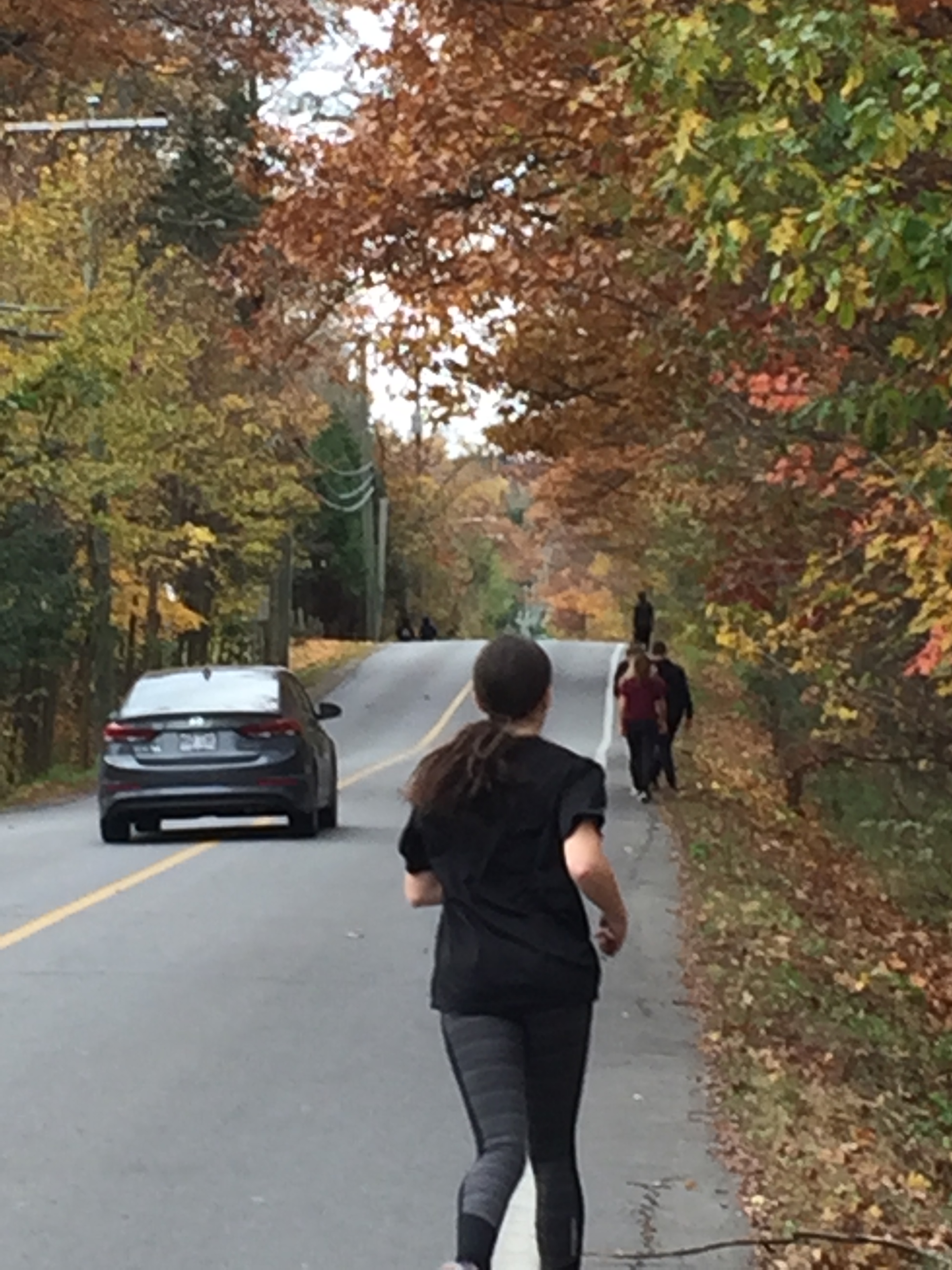
WSHS students out for a morning run on Côte St. Charles. What will it take to change public thinking on Hudson’s need for secure pedestrian/cycling corridors?
You’re looking at one of the biggest public security risks in Hudson, the absence of sidewalks and/or cycling paths on the town’s main streets. Here, a pack of Westwood Senior runners heads south on the two-foot-wide security strip along Côte St. Charles. A driver pulls wide around them near the crest of the hill. The driver won’t be able to see oncoming traffic until the last possible moment.
There have been a number of near-death experiences on Côte St. Charles. One involved a hit-and-run transport rig, another a school bus. Miraculously, nobody has been seriously hurt.
Cameron is equally dangerous, but for different reasons. The intersection with Harwood/342 routinely sees near misses as westbound vehicles in the Hudson turning lane conceal vehicles continuing west. Drivers waiting to turn left or right on Harwood sometimes don’t see the second vehicle until after they’ve begun their turn. Accidents are routine.
Cyclists and pedestrians avoid Cameron’s so-called bike/pedestrian path like the plague because they risk being trapped between traffic and the curb. Vehicles heading up the hill are often forced all the way over to the curb by oncoming traffic at the sharp downhill turn.
Over the past month I’ve spoken to scores of residents who resent having to risk their lives to go for a walk that includes being exposed on Cameron, Côte St. Charles and many parts of Main Road. They can’t let their kids walk to school. They can’t bike together as a family. They look with envy at the pedestrian-friendly, bike-friendly streets of St. Lazare and Vaudreuil-Dorion.
The one thing the town has always had in abundance are excuses for why residents can’t enjoy safe cycling and walking. The first conversation I remember took place when Elizabeth Corker was mayor. There’s no room for a right of way. We’d have to expropriate. We don’t want to take setbacks from residents. I remember hearing those same excuses at St. Lazare town hall meetings. The people who gave them were kicked out of office, but it took the tragedy of Patricia Jolicoeur’s grievous injury and a life-changing criminal record for a reckless young driver to change public thinking.
Safer streets can be incorporated in the promised repaving initiative, but it requires planning to do it as cheaply as possible. Ditches need to be excavated, storm drains and culverts installed, then backfilled and paved. Once wands or other removable separation devices are added, Hudson’s pedestrians and cyclists can walk and ride safely.
None of this happens by wishful thinking. The $1.5M road repaving loan bylaw presented last week is a drop in the bucket. But if we don’t get serious about making our streets safer, nothing will happen until something tragic does.
Earlier this week, a resident sent me this question on FB Messenger:
I live in the area formerly known as “Como” even though when I bought my house, it is Hudson. I notice in writings, such as your recent interesting article on WordPress people who have lived in Hudson a long time always have to refer to an address here as “in Como” ex: Thursday’s council candidates round table, 7:30 at St. Mary’s Parish Hall in Como”. When I meet my kids’ friends parents at Mount Pleasant and I mention where I live, many who are from here say “oh, you are in Como”. Why does that happen? Was there a cultural or economical divide between “Como” and “Hudson” that people who have lived here a long time need to make a comment? As a “newcomer” of 15 years, I am hoping you can shed some light on something that has always puzzled me. I pay Hudson taxes and will vote in the Hudson election. Just curious.
Here’s my response:
Prior to 1969 Hudson, Hudson Heights and Como were separate villages. Each had its own mayor and council and sent out its own tax bills. Each had its own post office and railway station (Hudson Heights also had Alstonvale and Choisy stations).
With the completion of the Trans-Canada Highway n the early ‘60s, the Three Villages saw an influx of new residents and developments such as Fairhaven. Their respective councils came to realize they shared a number of common concerns, the biggest being water.
In those days the residents either had their own wells or were supplied by a private company, Suburban Water. Suburban’s wells, reservoirs and aqueducts were old (pipes were a mix of lead, iron, steel, asbestos, even wood and dead animals occasionally tainted the open reservoirs). House fires were frequent in those days and there were no hydrants. Volunteer firefighters had to draft water from the lake.
Talk of merging the Three Villages was not new, nor was resistance. Heights residents saw little benefit other than water. Fiercely independent, Como had its own business sector and no interest in amalgamation.
Hudson had the most to gain because it had most of the region’s businesses.
In 1965, Hudson was a thriving regional shopping destination, with three grocery stores, four hardware outlets and dozens of businesses, even a sock factory. St. Lazare was a small agricultural community featuring some of Canada’s best-known riding stables and not much else. Vaudreuil was a summer community; Dorion, a separate municipality, was a truck stop.
We lived in Hudson Heights. My father and like-minded residents believed the three villages stood to gain from a merger. In 1961 my dad bought the only local newspaper, the Hudson Gazette, to campaign for amalgamation. It was a long, bitter battle. The Yes side won the 1968 referendum by a narrow majority. My father was seen by many Heights old-timers as a traitor because he challenged the discrimination that still prevailed throughout Quebec. (Irony: those social distinctions live on in the names of Hudson’s six electoral districts half a century later.)
Once the merger was law, negotiations began to buy the waterworks from Suburban Water and to install new water lines and fire hydrants. The town acquired new fire trucks and built the firehall that parks and recreation now uses.
The merger debate created grudges that remain to this day. If you have the opportunity to talk about this with old Como residents, you’ll occasionally get an earful on a bad day, when something triggers old memories.
There’s a longer version of the merger history. Back in 1999, when millennium projects were all the rage, I began my own, a recent history of Hudson, Hudson Heights and Como written from the Hudson Gazette’s archives, beginning in 1950. The Gazette Vaudreuil-Soulanges Millennium Project ran as 50 weekly instalments. Here are my Millennium Project columns covering 1966-1969:
1966
1966 blew in with astounding news – Ron Alloway, the nice guy who bought a place from Perry Bedbrooke in Mountain Ranches, turned out to be Charles Wilson, one of the members of the gang that stole close to $20 million from a British mail train carrying bags of worn-out currency for eventual destruction. The train’s engineer was beaten into a bloody pulp by the thugs during the robbery.
Arrested, tried and convicted on the word of informers, the gang split up and fled to different corners of the world after escaping from a Birmingham prison in 1964, a year into 30-year sentences.
Wilson, his ‘pretty blonde wife Pat ‘ and kids made their way to Canada via separate routes and settled in the Heights in the Pyke cottage before moving to Mountain Ranches.
He was a real charmer, read the Feb 1. Lake of Two Mountains Gazette. He paid his bills promptly, had a friendly wave for even his most casual of acquaintances, was a welcome member of Whitlock Golf and Country Club and was never known to have anything but a cheery smile on his face.
The only suspicion was how Alloway made enough money to support the house in Mountain Ranches, a wife and three kids. Locals were miffed that Alloway had conned them, but that didn’t stop them from hiding Mrs. Alloway and the kids from the hordes of British tabloid journalists that descended on the area like a pack of baying hounds.
In fact, Gazette publisher Ron Jones ended up removing a rifle and shotgun lying on the bed in the master bedroom – as if Wilson had been contemplating a last stand. Jones phoned various police departments, but nobody was interested in safeguarding the guns, let alone guarding the Alloway home from curious intruders.
At first, locals wanted the kids to be allowed to stay in Hudson. But as Ron wrote in an editorial, what about the children growing up in a community where everyone knows what and where their father is? We can’t curb the tongues of everyone, we can’t shield the children from the jibes of ‘jailbird kids’ they will inevitably receive.
That brought Ron a righteous blast at the next council meeting from both Heights Mayor David Aird and Chief Charlie Pooley, both who counted Alloway among their acquaintances. Their biggest beef – Ron’s characterization of Pat Alloway’s cockney accent and his suggestion that local kids might be bullied.
Amalgamation inched its way a step closer with a massive report that discovered that there would be (a) no major financial effects from a merger; (b) better services and (c) easier zoning. In fact the biggest debate was over what to call the new beast.
1968 marked the beginning of a Canadian motoring era – the first Toyotas went up for sale at the Village Pump and immediately were adopted by the rally crowd….meanwhile, Dolly, the old red Volks towed onto the ice off the government wharf, finally broke through and plunged into the lake. You could buy into a pool at the local Legion – before it was decided Dolly was an affront to Quebec’s environmental protection and gambling laws. Another Hudson tradition died.
What was to have been a gala Friday-night dance at St. Thomas School to mark the rebirth of Hudson’s Club des Jeunes turned into tragedy October 7 when 19 young people died in a bus-train crash in Dorion; Hudson police were bombarded with calls from anxious parents as news of the horror became known.
Meanwhile, the town was buzzing with the discovery of the body of an 18-year-old Roxboro girl just off Cote St. Charles. Heights’ cop Charlie Pooley turned the case over to the QPP, who refused to confirm reports Linda Blanchette had been strangled.
The Blenkinship homestead, one of the oldest buildings in Hudson, was heavily damaged by fire that October. Built in August, 1844, the house was so badly damaged, it was torn down.
Feelings ran high that fall in the editorials of the Lake of Two Mountains Gazette: The local blood donor clinic attracted 124 donors, far fewer than organizers expected. The Gaz railed on about community apathy.
Meanwhile, local youth including the young Jack Layton were trying to sell the idea of a youth centre as a worthwhile Centennial project for the three communities. The Gaz ran one of their letters on the front page and several more inside; essentially, the kids wanted a hall large enough for an average dance with a stage, snack bar, sound system, tables, chairs and maybe a juke box.
The kids’ demonstrations, letter-writing, even a 600-name petition – fell on deaf ears. The fix was already in; the Centennial Projects board for the Three Villages voted $30,000 to improve Benson Park, complete with wading pool, basketball court and better parking facilities. (One has to wonder what happened to the wading pool, basketball court and parking.)
But local outrage was reserved for a far more hypocritical decision. After coming down hard on Rigaud and the Three Villages for dumping raw sewage into the Ottawa, the Quebec Fish, Game and Tourism Ministry approved a sewage line into the Lake of Two Mountains to get rid of raw waste from Oka Provincial Park – immediately across the river from Ile Cadieux’s water intake.
The Heights had water woes of its own. Local resident John Vipond, whose property sat between Harwood Road and the lake, wrote to the Gaz after being told by Heights councillor Art Grubert to stop whining about a town ditch that was sending torrents of water into Vipond’s basement every time it rained.
Vipond’s beef: He didn’t see how Grubert had the right to tell him it wasn’t Town business. That prompted a flurry of letters suggesting it was okay for councillors to be rude because they weren’t being paid enough to be nice.
Blind pigs: Back in ‘66, locals would have had to drive to Dorion or Hawkesbury to buy booze. There’s no wonder, then, that enterprising locals would open blind pigs where locals could pick up a fifth of their favourite at any hour. Delivery was extra, but business was brisk; the Hudson Gazette reported at least four plying their trade right under the noses of the local constabulary and elected officials.
Amalgamation: The 20-year-old debate to merge Hudson, Hudson Heights and Como was heating up in Three Villages council chambers. But not for long – in December, 1966, someone from the Quebec Municipal Affairs Ministry produced a report showing the cost of running one merged municipality would be less than the bills for the Three Villages. After that, it was just a matter of time.
1967
Hudson Heights rang in Canada’s centennial year with an ugly political battle. At issue was the council’s new master plan that would have called for major changes to the community’s road network. • Ridge Road would be extended westward across Whitlock Golf Club to intersect Birch Hill, Brisbane and eventually Harwood Road; • An area on Harwood Road (now Lower Alstonvale) midway between Main Road and Highway 17 was designated a Civic Centre; • Main Road would be rerouted south of the CPR tracks to connect with Harwood Road, with the current Main Road terminating at a dead end just west of the tracks; • The area between Harwood and Choisy Station Road was to be zoned industrial and for multiple-family dwellings.
Outraged Heights residents banded together. Calling themselves the Citizen’s Committee for a Better Hudson Heights, they descended on the council meeting and forced the council to abandon the master plan – but not without being themselves accused of dirty politics.
The inevitable showdown came when the Citizens’ Committee ran a slate in the municipal elections, the first time the Heights mayoralty had ever been contested. Mayor David Aird faced former Gazette publisher Don Duff in a bitterly-fought election. At issue: Council’s insistence that Hudson Heights needed an industrial park to keep taxes down.
When the votes were counted, the council-backed slate was elected and the Citizens’ Committee gang frozen out – but they won in the end. The Heights master plan was scrapped.
The Three Villages desperately needed another doctor, but eyebrows shot up when Dr. Gilbert Croteau opened the area’s first chiropractic clinic, claiming to cure ’Headache, Bronchitis, Liver, Paralysis, Nervousness, Asthma, Backache, Hemorrhoids, Respiration, Digestion, Lombago and Menstruation’
But nobody could cure what ailed the local Centennial Committee. With barely five months to go to Canada’s Centennial, the local project to revamp the park on Yacht Club Road hit a brick wall in March when Como refused to pay maintenance fees for the proposed fancy new playing fields and chalets. Never mind that a third of the kids who used the existing park were from Como. Never mind that it would cost $6.50 per year per family, raged the editorial in the Gaz.
When July 1 finally rolled around, the Three Villages had done nothing permanent, but it was a fine summer for picnics and plenty of cross-Canada canoeists ended up spending time here.
Another local tradition ended in the Spring of ‘67 – the annual Viviry Creek Bottle Race. Alan Blenkinship, owner of the property bounding the creek, announced that due to the increase in the number of homes, the area was ‘too private’ for a bottle race. He urged organizers to take the race to another local stream, but interest faded. One happy note: Marg Gardner managed to uphold her personal tradition of falling in during the race – 14 of the 15 times she entered.
Insect infestation was a huge problem that hot, humid spring. Tent caterpillars and mosquitoes had locals demanding that Hudson spray the Fairhaven area with DDT and the heck with the birds.
Not so fast, said council – we’re not spraying until residents deal with leaky cesspools – a suspected source of regular outbreaks of infectious hepatitis.
1967 was also the summer that the local constabulary decided to crack down on free-running dogs and unlicenced bicycles. In the case of the hounds, too many kids were having to get rabies shots after having been bitten.
Expo ’67 brought plenty of house guests to the Three Villages, but nary a single lasting Centennial project, thanks to ongoing squabbling about the cost of maintaining an upgraded athletic facility on Yacht Club Road.
But the end of summer was just the beginning for the local horsey set as riders from across Eastern Canada converged on St. Lazare for various equestrian events. It was an open secret that George Jacobsen and other guiding lights behind the Montreal and Lake of Two Mountains Hunt Clubs felt they had the inside track for the upcoming 1976 Olympic Games equestrian events. (They eventually went to Bromont, thanks to the Desourdy family’s courting of Olympic officials.)
There were plenty of complaints about the local car rally enthusiasts. Volvos, Triumphs, Coopers, MGBs – and Steve Thom’s eclectic Mercedes collection – spent weekends hammering along the back roads in St. Lazare and Vaudreuil, kicking up rooster tails of gravel and dust. Whatever the complaints, the Lake of Two Mountains Car Club had enthusiastic members and a column in the LTM Gazette.
There was plenty of new construction off Cameron Avenue, but the best deals in 1967 were in the Heights. Four bedrooms on a big lot with old trees overlooking the lake: $27,500. Mortgages were being offered at 5 1/2 per cent.
Canada’s Centennial Summer did have one local effect – the plaquing of historic properties in the community. First to be plaqued was the rambling white home on Mount Victoria once owned by George Matthews, after whose wife Elizabeth Hudson the town was named. Then came Mullan’s General Store, built in 1824 as a schoolhouse, courthouse and church – on different days of the week, of course.
Marcel Patry, the last owner of Mullan’s General Store before its transformation into a private residence.
The plaquing frenzy climaxed early in October, with a plaque-a-thon organized by the Hudson Historical Society and the Women’s Canadian Club. All three mayors and scores of history-minded locals spent an entire weekend unveiling plaques on 17 buildings. At least half of them have since been renovated, destroyed by fire – or torn down to make room for new homes without architectural merit.
The 20-year-old debate over whether the Three Villages should get married continued to drag on. Quebec was pushing these shotgun weddings in order to save money, but Gaz publisher Ron Jones wasn’t impressed with their tactics. One example: The three local councils were invited to a closed-door meeting at Whitlock – and barred Ron. Bad move. His double-barrelled counterblast came in a heavily-slanted article entitled A Nothing Story and in an editorial headed Fusion Confusion.
No wonder Quebec wanted to keep it a secret. Figures released just before Christmas, 1967 showed Hudson Heights would be the biggest tax-bill winner after amalgamation – from $60 per capita, to $46. Como would jump from $35.
That was the fall the Hudson High senior football team won the Greater Montreal Football Championship. Steve Doty’s team, led by team captain Larry Smith’s pass reception, became an HHS sports legend.
But interest in local athletics was dying. Residents resisted any attempt to use any part of their taxes to pay for upkeep of the town rink and playing fields at Benson Park. Not only that – an emergency meeting discovered that although the Athletic Association paid a dollar’s rent on the land, nobody knew who owned it.
1968
After 50 years of endless debate, the Three Villages voted in 1968 to merge into the municipality of Hudson. It took all year.
All three councils held public meetings in April to allow residents to vent their concerns; attendance was poor. In Como, the farmers wanted to keep taxes down but others wanted the roads paved; Hudson was concerned it would have to pay for services in the other two communities. Hudson Heights couldn’t afford to clean its ditches and big landowners were facing enormous tax evaluations.
But when the issue went to a three-village referendum on Wednesday, May 15, Como voted against. Turnout was poor; of the 1220 eligible voters in the Three Villages, only 583 voted. But this was not to be Como’s last word; in September, the town mailed out ballots to its 295 ratepayers. Of the 212 returned, 184 voted yes to amalgamation.
From then on, things happened quickly. In December, 1968, Hudson Mayor George Runnells declined the job heading the new provisional council; Doc Runnells was about to turn 90. Heights Mayor David Aird also declined, making Como mayor George Armstrong Hudson’s provisional mayor.
The Three Villages already had a combined police force by then. Vandalism was on the increase and hardly a week went by that somebody’s car didn’t get taken for a joyride, thanks to the trusting local habit of leaving keys in the ignition. Problem #1 was the cost of full-time policing. So in August, Hudson Heights agreed to merge its police force with that of Hudson-Como. Heights Chief Charlie Pooley promptly retired.
Spring 1968 brought the usual demand that something be done to ‘get rid of’ mosquitoes; some locals still thought the best treatment was DDT. That brought a torrent of angry letters from birdwatchers and one from zoology student Randi Olson, who pointed out that any pesticide is concentrated as it moves up the food chain, affecting birds, fish and other beneficial species.
In the end, it was only Alastair Grant, real estate agent, mining promoter and noted local eccentric, who spoke out in favour of a massive aerial DDT bombardment of the local mosquito population.
Real estate in ‘68 was still a bargain. A nine-room, five-bedroom house on half an acre of mature pine in Hudson was going for $25,000. In Como, Royal Trust agent Donella Darling was selling 20 lots in Hawthorne Park, just west of the Willow, for $3,500 apiece, 10 per cent down. Hawthorne Park? It’s now Leger Lane. Also renamed: Como Station Road became Bellevue Drive after CP tore down the old station.
The summer of ‘68 saw a lot of roadwork – like the widening and repaving of Macaulay Hill, the disappearance of the hump on Cameron at Lakeview and the straightening of Como’s deadly Parsons Corner. It also saw the startup of an employment agency for local teens.Teens Unlimited was given office space at Hudson Heights Town Hall, where residents could connect with local teens looking for odd jobs.
The fall of ‘68 saw another debate pit Hudsonite against Hudsonite. Some locals, including Hudson’s sizeable population of pilots, wanted the federal and provincial governments to build a proposed mega-airport in St. Polycarpe.
Others were aghast at all that noise and traffic.
Don’t worry, Air Canada pilot Alan Mills wrote in the Letters section. The new generation of aircraft is much quieter. Besides, look at all those new jobs we’ll be getting, Mills wrote.
In the end, Mirabel got the nod.
— Millennium Project, by Jim Duff, from Gazette Vaudreuil-Soulanges archives
This bird was cooked slow and low under foil and needed a last-minute browning blast. Thanksgiving’s power failure altered dinner plans for thousands of households.
Four weeks into the official municipal election campaign and I’m hearing about issues that never get mentioned in public discussions. Here’s one we can all relate to.
A Whitlock West couple whose Thanksgiving turkey dinner was disrupted by that Sunday power failure wondered what could be done other than installing a generator. Although their neighbourhood boasts underground power lines, residents are hit by the same power outages that all too often darken the triangle between Harwood Blvd., Alstonvale Road and Côte St. Charles.
Could the Town of Hudson intervene with Hydro Quebec to limit power failures? Hydro Quebec says its crews are in the midst of its ongoing preventive pruning program, but interventions are limited to ensuring a minimum clearance for transmission lines. Hydro pruning crews don’t attempt to identify and fell every tree with the potential to cause outages because they don’t have the resources.
Do Quebec municipalities have a legal responsibility to limit the risk from downed trees? Jurisprudence is scarce. A St. Lazare resident took the city to small claims court after trees along a town-owned Hydro servitude destroyed appliances and knocked out his power for several days. He lost. There was talk of a class action lawsuit but lawyers couldn’t agree on who to sue.
After a town-owned rotten poplar fell on Gabriel Rossy’s car, killing him in 2006, his family fought all the way to the Supreme Court for the right to sue the City of Westmount instead of accepting a Quebec Automobile Insurance Board settlement. They lost, but only because he was in his car. If he had been walking or cycling, would the courts have decided otherwise?
Quebec law holds the property owner responsible for damage if it can be proven a tree was unhealthy or otherwise presented a risk, but who is prepared to waste time and money to track the root cause of a power failure that delayed Thanksgiving dinner?
Property owners have a legal responsibility to manage any of their trees posing a risk to their neighbours. I think the town should set an example by tending to trees on public land with a potential for risk. Right now I’m looking at an otherwise healthy shagbark hickory on the town setback with a crack starting at a bole 25 feet above the pavement. If that branch was to break off, it would take out the neighbourhood power lines and could easily kill someone happening by at that moment.
Hudson is lucky to have a number of tree-care professionals with the experience to judge whether a tree poses a risk and the expertise and equipment to deal with it. A permit is needed to fell a tree more than four inches in diameter, but Hudson’s technical services division is quick to inspect and issue a permit.
Back to the core question: what if anything can the town do to reduce blackouts? Anyone who lived through the ’98 Ice Storm and Hudson’s all-too-frequent blackouts would be curious to know the answer. I know I am.
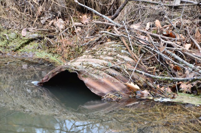
Clogged Hudson culvert. Preventive maintenance would work wonders but what would it cost to get ahead of the problem?
Less than two weeks to go to voting day and candidates are getting antsy as the mayoral and council races close up. This is the way of things in elections. Someone who scored last week’s mayoral candidates’ debate put Nash and Nicholls within a few points of one another.
Questions I get most often going door to door in this campaign: who are you running with, what’s your platform and who should be Hudson’s next mayor. I’m guessing we’ll be asked that last question at Thursday’s council candidates round table, 7:30 at St. Mary’s Parish Hall in Como. Get there early.
Officially, every one of the 15 candidates in this election is running as an independent. There are no parties or slates, but alliances and clandestine hookups are emerging. This is how politics is played in Hudson, in private as Hudson’s special-interest lobbies scramble to ensure they have horses in this race to town hall, where they’ll be competing for influence and financial support.
None of that is of concern to District 5 voters I’ve met in my door-to-door walkabouts.
Last week a Ridge Road resident invited me for a drive around the block. He wanted to show me a drainage problem in his neighbourhood which causes his back yard to flood most springs. The network of ditches and culverts that should be draining water from Oakland into the big interceptor running along the back of Ridge are clogged with leaves and yard waste. He maintains the town has neglected to clean them out regularly. This has been going on under the last two administrations; he even won a lawsuit against the town in small claims court.
What can you do, he asked me, “and if you say ‘nothing’ I won’t vote for you.”
I can’t blame him. He’s had it with the town’s intransigence. He was particularly upset over the fact the town installed new drainage culverts when repaving that bombed-out stretch of Ridge Road this summer. Those culverts solve nothing because the ditches and culverts downstream are blocked.
Politicians don’t like ditches and culverts because they’re boring. But ditches are crucial to Hudson’s health. Bad drainage speeds the freeze-thaw deterioration cycles destroying our roads. Blocked culverts shorten the lives of our septic tank weeper fields. Clogged ditches stink and breed mosquitoes. If Hudson installed culverts and drains in the roadside ditches lining our major arteries we could backfill and pave them over to create pedestrian and bike paths.
Drainage is a problem even in parts of District 5 connected to the sewer system. At one house I visited, the owners were excavating a ditch along their property line to channel the water from their sump pump to a culvert running under Maple. It looked to have collapsed, prompting me to wonder at the wisdom of repaving without tackling drainage problems.
I don’t think it’s a personnel problem. Hudson’s technical services personnel were responsive and efficient in dealing with concerns in District 5 where we live, and in District 3, where we have a business. But whatever system the town has in place to track drainage problems doesn’t seem to be working on Ridge.
It seems to me that the cleaning of ditches and culverts should be ongoing. Maybe they don’t have to be scooped out every year but someone should give them a look and check to see they’re flowing. If they’re clogged, someone has to decide whether it’s a one-day job with a backhoe and a couple of guys with shovels or a major project requiring excavators, cofferdams and a big crew.
Other MRC municipalities seem to have groundwater problems under control. They fix broken things without having to hire consultants and they seem to be able to do it for less.
A Hazelwood resident told me Côteau du Lac mayor Michel Jasmin doesn’t buy new town vehicles. He buys two-year-old vehicles off lease, with warranties. He hires local kids to cut the grass in town parks, hands them the keys to the park chalets and makes them responsible for maintenance. There’s no graffiti, no garbage and very little vandalism because the kids take ownership.
This summer, Côteau du Lac spent $6 million repaving its streets. Instead of floating a loan bylaw, the town paid cash. Like that Hazelwood voter said, there’s nothing wrong with being small-town cheap if it allows us to avoid borrowing needlessly.
That Ridge Road resident who threatened not to vote for me without a promise? I told him I’d make his drainage problem my drainage problem.
•••••••••••
At our weekly Sunday gathering a neighbour asked what could be done about a dog that barks incessantly. “Six hours one day,” she said. She looks after a dog herself when its people are out of town and finds it just plain cruel. There’s a town bylaw but it’s vague and and difficult to enforce if there’s nobody home to let the poor beast in, which is usually the case. So she called the SQ.
I’m trying to figure out how it should work. The SQ is too overworked and understaffed to deal with nuisance complaints. The Community Patrol has been stripped of its bylaw enforcement power. The town pays for the services of an animal control agency but they’re not allowed to break and enter to deal with canine scofflaws. In other municipalities, pet ordinance violators receive tickets in the mail and are hauled into regional municipal court if they don’t cough up.
•••••••••••
I’m coming across a fair number of neighbour/neighbour squabbles. Most involve trees, dogs, fences and water rights, but this past week I heard a new one: chicken-keeping households are attracting foxes and the foxes are eating all the rabbits because the henhouses are too well built.
What’s the answer? Regulations decreeing rickety henhouses?
Never a dull moment for whoever’s elected here in waterlogged, dog-loving, chicken-keeping District 5.
Hudson’s District 5: a socioeconomic crazy quilt stretching from Lower Alstonvale to Lower Maple.
In a previous post I said I wouldn’t burden you with lurid anecdotes from the campaign trail. That said, I’m being pressured to pronounce myself on what I stand for.
Bear with me while I try to walk the talk through District 5 and its 835 registered voters.
District 5 is far and away the wierdest electoral distribution in Hudson’s 2017 municipal election, a socioeconomic crazy quilt. I was told Hudson’s former urban planning director was ordered to redistribute Hudson’s eligible voters into socially and geographically distinct districts. If that was her mandate, it was a failure. District 5 takes in all of Côte St. Charles and a third of Main Road. It stretches from Lower Maple to Lower Alstonvale, from Whitlock West to the path that connects the fragments of Hazelwood. It includes some of Hudson’s oldest and newest streets. Roughly a quarter of the homes are on the sewer system; almost everyone on a septic tank would like to have the choice. The addresses from the foot of Macauley Hill to the Cameron farm don’t have town water.
Over the past two weeks I have knocked on the doors of modest cottages and opulent riverfront spreads as I explore District 5 on foot. I’ve introduced myself to residents doing their own roofing and explained my presence to housekeeping staff over camera-equipped intercoms.
I’ve come up with some interesting observations. For example, it’s best not to enter a home where the sound of a knock or doorbell is met with furious barking, especially if one has already been greeted by dogs or cats elsewhere. I made that mistake early on in my door-to-door walkabouts. The elderly resident invited me in. I was greeted by a morbidly obese creature that looked like a pitbull-mastiff cross. The dog was fascinated with the smells of other dogs and cats on my pants. Not in a friendly way. Only the dog’s clumsiness saved me.
I now understand a beef I often hear from Hudson’s firefighters and first responders: Why doesn’t Hudson require every homeowner and landlord to post civic numbers? Many municipalities don’t even give their residents the choice. The town plunks steel poles with reflective numbers at the entrance to each driveway. How often did I find myself retracing my steps to find 49A this or 555 that? The law says every civic address must post a number visible from the street on which it is registered. Not in Hudson.
I’m also learning doorbell/knocker etiquette, beginning with respecting personal space. After ringing or knocking, step back so that one foot is off the porch or stoop. When someone answers, you’re not in her/his space and probably lower and less threatening and the person isn’t forced to assume a defensive posture with the door between them and you.
I try to make human contact, and that doesn’t include handing them a flyer. I get them talking. And talk they do. They spill out their frustrations, their pet peeves, their wishes and their regrets. For a lot of people I think it’s cathartic to vent.
Here, in no particular order or priority, are some of the things I’ve heard:
Granny suites: Once the kids or parents are grown and gone, many homeowners would like the option of turning that extra space into something they can rent legally. This is a conversation we began having during the Corker administration. Why hasn’t the town moved on this?
Development: Whether we’re talking Sandy Beach, Ellerbeck or Norris, why should large-project developers be allowed to hook up to town water and sewers without being responsible for replacing the capacity they’re taking from sectors which don’t have water or sewers? They should be held responsible for replacing the water and sewer treatment capacity their developments are using. The town should prioritize the installation of sewers in many sectors where septic tanks are clearly not working properly.
Pine Lake: It’s a symbol and its loss represents Hudson’s crumbling infrastructure. Even Pine Lake’s most fervent advocates don’t want the town to throw good money after bad on more experts and studies. If there’s a way to do it on the cheap, give us back our iconic little lake that once welcomed everyone.
Roads/pedestrian paths: People have figured out the interconnection. Hudson’s roads are in terrible shape but there’s no point fixing many of them unless the town is ready to widen and rebuild from the roadbed up. While we’re at it, why can’t we add pedestrian/cycling paths that separate their users from traffic?
Snow removal: Rather than going with the lowest bidder, why is the town not considering cost plus? Residents are stunned when they learn the town is paying $400,000 a year plus taxes as well as footing the bill for salt and sand (another $200,000+ last winter). Other municipalities closely supervise their snow-clearing contractors in real time, someone who knows the industry told me.
Public security: Main Road and Côte St. Charles residents are fed up with reckless drivers and speeding, break-ins and noisy trucks. One resident living near a stop sign on Côte Road drew my attention to a transport using engine compression to slow down instead of applying its air brakes. Most municipalities have bylaws prohibiting the use of these Jacob brakes in populated areas; Hudson doesn’t. Crescent residents complain about the near-daily presence of drug dealers on their street at times when students are outside Westwood Senior High School. Why doesn’t the administration work out a deal with the SQ for a few hours of extra policing a month? Other MRC municipalities occasionally avail themselves of ‘SQ à la carte’ to crack down on impaired drivers, reckless driving and park security as well as the sale and use of drugs in parks and playgrounds.
Public space: I found a good way to get people talking was to ask them about Sandy Beach. The common answer: we used to go there. We don’t any more because it’s full of people not from Hudson who disregard the leash laws, trash the place and don’t pay a cent to its upkeep. Charge them for parking. Enforce the bylaws. Don’t settle for a servitude giving public access to the beach. Demand that Nicanco hand over the entire beachfront and a green buffer between the beach and its development.
Taxes: What’s too much? This year, the town adopted a revised budget based on a $12 million tax load, a 4% hike over 2016. (Although Hudson finished 2016 with a $916,000 surplus, $240,000 of that was earmarked for unbudgeted flood-related expenses.) One of the first tasks the incoming council will face is the adoption of a 2018 budget based on unaudited data from 2017. (Quebec allows an extra month because it’s an election year.)
One longtime resident said he was prepared to take a 10% tax hike if it meant better roads. I ran into another as she was emptying her house. She and her husband were splitting up and she has no choice but to sell and move with her daughters to somewhere cheaper. Not far away, another family had sold their house and are preparing to move to Rigaud because the wife can’t or won’t work and the husband’s salary isn’t sufficient. Why Rigaud? Because their youngest can continue to attend the Hudson school where the quality of the teachers will give him a chance at a better future. Hudson is getting too expensive for the working poor.
I ran into one of Hudson’s real estate agents as she was showing a home to a potential buyer from B.C. For someone on the verge of retirement whose Sunshine Coast or Scarborough home will sell for $1.5 million, Hudson is a bargain. For those who hope to remain here, property valuation increases driven by flip investors and contractors will continue to inflate taxes.
Affordable housing: My visit with one energetic senior repeated itself dozens of times throughout my walkabouts. She lives alone in a beautiful house overlooking a forest. She doesn’t want to give up her home, filled as it is with memories of her late husband. Her children and grandchildren visit but the day will come when she will have no choice but to downsize when she can no longer drive. A volunteer herself, I sensed that she will resist that as long as humanly possible.
What would be your idea of paradise, I asked her. Kilteevan, she said without pausing. It’s too far out of town but it’s perfect. Everyone there minds their own business unless someone is in need — and she can have a little garden.
I get it because I’ve seen it. The lady writing herself Post-It notes to remind herself of things she must not forget, then forgetting where she puts the notes. Women bury their husbands and live alone in their beautiful Hudson homes with their big dogs because there are so few communal facilities that will take pets. I realize it’s no really about affordable housing, but suitable housing, housing where someone with the means can find a niche that will shape itself to their needs. Would I like to be institutionalized, have to give up my dogs?
I raised some of these issues with one of my neighbours. “What’s that got to do with the city,” he kept asking. The inference was that all of this door-to-door bleeding-heart crap was softening my brain.
I don’t see it that way. Going door to door is total immersion in what Hudson wants and needs as well as a humbling lesson in who we are. Long after the campaign bombast has been forgotten, these are the conversations I’ll remember. Thanks, everyone, for taking the time to share what matters. If I haven’t gotten to you yet, I will.
I’ve made it my rule during the Hudson election campaign to refrain from commenting on partisanship eruptions in races that don’t concern me.
But that doesn’t mean biting my tongue when it comes to setting the record straight.
By my rough estimate, the outgoing administration has spent well over $100,000 on studies and inspections to the Pine Lake dam and Cameron culverts. Analysis paralysis, one District 5 resident called it yesterday during my door-to-doors.
There’s a consensus that Hudson needs its iconic pond back, but not at any cost. Many are enthusiastic about getting involved in the reconstruction, just as the original Pine Lake dam was built. Rent some heavy equipment and get everyone out with shovels and wheelbarrows for a traditional Hudson workbee.
Before someone suggests yet another study by yet another engineering firm, here’s the definitive analysis of the situation carried out by an unpaid team of Hudson residents, many of them unquestioned authorities in their respective fields. I would suggest that anyone pretending to be an expert should take the time to read it.
Sheila Britt, Germain Laporte, Martin Lechowicz and Ken Walker
(with input from Tom Birch and the late Gordon Thompson)
The original mandate of our working group as recorded in the minutes of our meeting of 3 December 2014 with the Director General at that time (Catherine Haulard) was “…to provide Council with a recommendation as to what type of dam(s) could be constructed taking into account various factors that have bearing on the choice of a type of structure”. Furthermore: “The objective is not to determine if a dam should be built or not but that if one were built it would be the committee’s mandate to indicate which concept would be the most appropriate. The Town will ultimately decide the scope of building and the type of dam.” Our mandate was expanded in a meeting on 12 January 2016 during a discussion with Jean-Pierre Roy, the present Director General, to include consideration of leaving the broken dam in place, removing the broken dam without replacement, as well as various options to repair or replace the dam. Mr. Roy recently convened a ‘group of seven’ from the town staff to evaluate our review of options (i.e. scenarios), which should be delivered no later than March 2016.
This document presents six scenarios intended to frame the discussions of the ‘group of seven’, including 1) an outline of each scenario, 2) necessary considerations in evaluating each scenario, 3) tasks required to complete the evaluation, and 4) our scoring of the scenario based on currently available information. The scores are based on our working evaluation of: 1) ecological integrity and efficacy in flood regulation, 2) aesthetics and provision of public amenities, 3) construction and operating costs, 4) legal and regulatory constraints, and 5) work required to finalize plans and cost estimates. We emphasize that our scores are tentative and are likely to change to some degree as the additional information we have called for becomes available.
We note that during our discussions we have been cognizant of the September 1984 motion in council by which the town took responsibility for Pine Lake. Given subsequent changes in the regulatory environment governing dams and public works associated with wetlands, however, we decided to consider a wide range of options without necessarily being bound by the sometimes conflicting or constraining terms of the 1984 motion. As the mayor and council have the ultimate responsibility to do what is best for the present and future citizens of Hudson, we leave it to them to reconcile the spirit of the 1984 motion with the scenarios we present.
All members of our working group, past and present, are residents of Hudson; we possess a wide range of professional and personal experience relevant to our mandate:
Tom Birch is a former town councilor with an IT background and involvement in venture capital initiatives who contributed to our early discussions, but was unable to stay involved.
Sheila Britt has worked in business administration; she lives on the shore of the former Pine Lake and has clearly represented the concerns of lakeshore residents in our discussions.
Germain Laporte has a background in public policy and procurement issues in the federal government, including experience in tendering and evaluation of bids.
Martin Lechowicz is a McGill university professor studying environmental linkages between rivers and their watershed, including flood risk and water quality issues.
Gordon Thompson (recently deceased) was a civil engineer and founding CEO of a large consulting company engaged in environmental management.
Ken Walker is a mechanical engineer and former vice-president in the pulp and paper industry with some experience in construction of dams.
We are grateful for the assistance of the town clerk, Vincent Maranda, who participated in our discussions and played a liaison role to the town administration. Anna Luz in Martin Lechowicz’s research group conducted the GIS analyses to create the images depicting the various scenarios.
Some general considerations
Throughout our discussions we recognized that the problem at hand is not simply a question of the restoration of Pine Lake. Although the dam on Pine Lake was initially built by local residents during the 1940s to create a recreational amenity, the dam also altered the normal flow of the Viviry River and functioned as a flood control structure during intense rainstorms and periods of rapid snowmelt in spring. All dams prevent the normal downstream flow of sediments, which steadily accumulate in the impoundment behind the dam. Over time the accumulating sediments reduced the ecological health and aesthetic quality of Pine Lake as well as the ability of the dam to function in flood control.
The dam on Pine Lake failed during a flood event. Because of this, as well as ongoing climate change, flood control has loomed large in our consideration of the options available to address the April 2014 failure of the Pine Lake dam. The peak flows during flood events in coming decades inevitably will be greater than in the past because: 1) future land development within the watershed of the Viviry River will increase runoff and sedimentation rates and 2) the frequency of intense rainstorms that pose the most serious flood risks will increase because of climate change. Hence, we cannot simply replace the failed dam, which was designed and built in 1990 to norms that are no longer viable. We must find an affordable and effective solution that both restores the amenity value of the lake basin and reduces the present and future risk of damage due to flooding.
REFERENCE DOCUMENTS
Available consulting reports done for the town of Hudson
EXP – May 2014 Barrage ruisseau Viviry – Étude préliminaire. 29 pages
AMEC – June 2014 Étude hydrologique du bassin versant de la riviére Viviry au Lac Pine. 64 pages GHD – September 2015. Étude géotechnique : Reconstruction du barrage du ruisseau Viviry. 45 pages.
Selected scientific literature on climate change impacts in the context of Quebec
Huard, David, Diane Chaumont, Travis Logan, Marie-France Sottile, Ross D. Brown, Blaise Gauvin St-Denis, Patrick Grenier & Marco Braun. (2014). “A decade of climate scenarios: the Ouranos consortium modus operandi.” Bulletin of the American Meteorological Society 95: 1213-1225.
Ouranos (2015). Vers l’adaptation. Synthèse des connaissances sur les changements climatiques au Québec. Édition 2015. Montréal, Québec : Ouranos. 415 p.
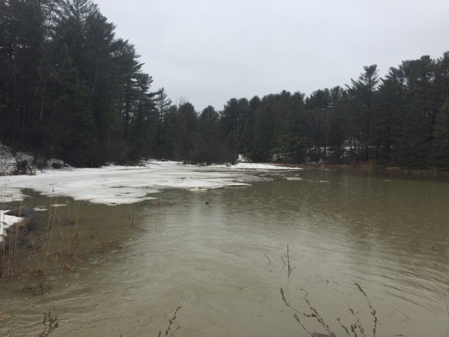
Figure 1. Pine Lake basin on 18 June 2014, two months after the dam failed. During summer 2014 the lake bed was colonized by meadow grasses and wildflowers, which persisted in 2015. The damaged dam is in place, and flood waters have partially and temporarily refilled the lake basin during intense rainstorms in 2014 and 2015.
Note that the Viviry River flows through the drained lakebed and a major tributary (Black Creek) flows under Cameron Road into the lake basin to join the Vivery just upstream of the present dam site. This is noteworthy because the Black Creek sub-basin accounts for30%oftheViveryRiverwatershed,whichsignificantlyincreasestheamountoffloodwaterreachingthepresentdamsite. In consideration of ongoing climate change this is worrisome in that only 27% of the Black Creek drainage basin is in Hudson — we do not control land development in the other 73% of the sub-basin that lies in St-Lazare and Vaudreuil-Dorion. Runoff and sedimentation into Black Creek will increase as land is developed in the sub-basin. Hence flood risk is likely to increase in future.
This scenario would LEAVE THE OLD DAM IN PLACE, which is the situation that has prevailed since April 2014. Based on ecological principles, old photos from before the dam was built, and vegetation presently upstream from the lake basin, the river shore likely will become a grassy meadow. Eventually an alder thicket will develop near the river edge and in low areas prone to flooding, and higher ground that is less likely to flood will be colonized by upland tree species. The riverside meadow and alder thickets will flood during storm events and snowmelt, conferring some degree of flood mitigation downstream. In the long run there is likely to be damming by beavers on the stretch of the river between St-Charles Road and Cameron Road; their dams will further reduce the peak flow during flood events.
Considerations
This may not really be an option — we do not know if the ministry would allow leaving the stream obstructed by the old dam, or what requirements might be imposed in that case.
If the damaged dam can be left in place it still needs to be stabilized and its ramshackle appearance made more presentable; the cost of this work is unknown.
Some additional stabilization of the shoreline immediately adjacent to the dam will be required, i.e. along the berm on public land along Cameron Road and on Cynthia Maher’s property. The cost of this sort of work was included in the estimates prepared in May 2014 by EXP (cf. alternative #4)
The dam in its present condition provides modest and unregulated flood control, which means peak floods in the future might cover Cameron Road at the Black Creek culvert, impeding traffic and weakening the roadbed.Flood risks are likely to increase in future due to both ongoing climate change and land development within the watershed
The Cameron Road culvert and especially the Black Creek culvert may need to be replaced. The town will have responsibility to clear sediment and ensure good downstream flow in both culverts. Failure to maintain flow in these culverts poses some risk of the river washing out the roadbed during a flood event.
We do not know if the ministry would allow routine clearing of sediment in culverts; restrictions may be imposed that complicate the work and increase the expense of sediment removal.
At some point sediments will have accumulated in the lake basin to a point where dredging and recontouring of the old lake basin may be required to maintain even modest flood control; this work will require regulatory approval.
Tasks
Do current Quebec and federal regulations allow leaving the broken dam in place? If so, what would be the cost to stabilize and approve the appearance of the structure?
Would current Quebec and federal regulations allow routine, unrestricted cleaning of sediment in the culverts under Cameron Road? If sediment removal is allowed by government, then the frequency and costs of this routine work should be estimated and responsibility assigned to someone on the town staff.
What liability, if any, does the town bear for any loss of property value associated with a failure to restore Pine Lake? What would be the consequent costs?
Are there any government or public-private programs available for cost-sharing associated with this scenario?
If this scenario were to be implemented, what would be the total estimated cost of the immediate work, including
interest paid on any loan required to complete the work? The operating costs over time?
How would the cost be shared between subsidies, taxes levied on the town as a whole, and taxes levied on residents whose properties abut the lake?
Summary
Of all the scenarios, this one probably has the least financial cost in terms of immediate work and also in subsequent operational costs, but Pine Lake will not be restored. Hence there are political issues as well as questions of liability and recompense to nearby property owners to be considered.
Scenario 2: Remove the old dam, ± create a riverside park
REMOVE THE FAILED DAM: This scenario involves removing the failed dam at an estimated cost of at least ~$147,970 (cf. EXP consultation – May 2014), which will result in a free-flowing river; the riverside could either be left unmanaged or managed as a riverside park. Once the dam is removed, the Cameron roadbed with its culvert restricting high flow rates could essentially act as a check dam so long as the roadbed and shoulder were properly reinforced. That would back up some water to flood the riverside meadow during peak flow, but that temporary impoundment in turn would reduce the risk of downstream flooding.
Considerations:
The EXP cost estimate for dam removal already includes some stabilization of the river channel and banks to withstand erosion during floods as the river flow converges on the culvert under Cameron Road.
There will be ongoing operating costs to keep the culvert under Cameron Road clear of sediment to ensure good flow during storm and snowmelt events.
Ministry approval will be required for the work to remove the dam, and perhaps also for any regular sediment clearance in the culvert.
The risk of flooding Cameron Road at the Black Creek culvert should be assessed by a qualified professional; the roadbed and adjacent terrain may need to be raised in this low-lying section and the capacity of the Black Creek culvert increased. The EXP report did not consider this point; this section of road has flooded in the past.
Any work on Cameron Road at Black Creek will block access to the village center; a detour at Mount Pleasant will be impossible, so only Bellevue and St. Charles will provide village access during the construction work.
Since flood risks will increase in future due to ongoing climate change and land development, raising this section of Cameron Road and improving flow through the Black Creek culvert may be necessary. The costs and benefits would need to be evaluated, as well as the degree of urgency of the work.
If substantial construction work were to be done along Cameron Road, there would be an opportunity to use available earth moving equipment to recontour areas adjacent to the river in order to convert the riverside into a public park. With proper redistribution of lakebed sediments parts of the park could be above flood levels and other parts allowed to flood to reduce downstream flood risks during storm and snowmelt events. Professional consultation would be required to coordinate the recontoured surface with the redesign of culverts or bridges on Cameron Road.
8. A sediment analysis would be required before moving and/or removing materials in the former lake bed, and the work would require ministry approval.
Tasks:
If the lake bed sediments are to be disturbed, it may be necessary to provide the ministry a sediment analysis before any work will be approved. Inquiries should be made to the ministry regarding the requirements.
If sediments are contaminated, the ministry could force their removal and proper disposal – consequent costs should be estimated.
Would current Quebec and federal regulations allow routine, unrestricted cleaning of sediment in the culverts under Cameron Road? If sediment removal is allowed by government, then the frequency and costs of this routine work should be estimated.
The risk of flooding over Cameron Road at the Black Creek culvert should be evaluated and necessity and urgency of remedial work considered.
If a riverside park were to be developed, what would be the cost of its design, construction and maintenance?
What liability, if any, does the town bear for any loss of property value associated with a failure to restore Pine Lake?
Are there any government or public-private programs available for cost-sharing associated with this scenario?
If this scenario were to be implemented, what would be the total estimated cost of the immediate work, including interest paid on any loan required to complete the work? The operating costs over time?
How would the cost be shared between subsidies, taxes levied on the town as a whole, and taxes levied on residents whose properties abut the lake?
Summary
If the ministry requires removal of the damaged dam, we will be forced to assess and mitigate any risks to Cameron Road and/or downstream flood risks. There could be an opportunity to develop a riverside park for public enjoyment at relatively low cost while heavy machinery is on site, although with some temporary disruption of traffic along Cameron Road.
Scenario 3: Restore the old dam, recreating Pine Lake
Fig 3. The Viviry River and its tributaries; the yellow line delimits the watershed – rain and snow melt within the watershed boundaries contribute significantly to flow in the Viviry River. Tributaries flowing north into the Viviry are fed by a combination of surface runoff plus a significant amount of groundwater leaking from the St-Lazare Plateau, a shallow aquifer under the subwash fan deposited during the retreat of the Laurentide Ice Sheet ~9500 years ago. Groundwater in the St-Lazare Plateau mostly originates as rain and snow melt outside the Viviry River watershed. A similar combination of runoff and groundwater sources prevails in south-flowing tributaries originating on the Hudson Highlands, which are another subwash fan laid down by the melting ice sheet. Well-water drawn from these shallow aquifers will reduce flows into the Viviry River as future development increases water use. The solid red stars indicate positions of existing check dams that provide some flood control along the Black Creek tributary; open red stars indicate sites of old beaver dams that could be rebuilt into check dams along the main river channel.
RESTORE THE OLD DAM, RECREATING PINE LAKE: The EXP consulting report estimated the cost of repairing the 1990 dam that was damaged in May 2014 to be $462,707 but without provision for dredging the lake basin to create adequate flood control capacity and an ecologically viable lake ecosystem. Repairs to the 1990 dam combined with dredging of sediments and construction of check dams upstream might yield a healthy lake ecosystem and viable flood control, although given increasing flood risks this is not certain in the long run.
Considerations:
The normal level of Pine Lake is set by the design of the dam; the original dam built in 1946 set the normal lake level at the 100 foot contour. This led to the lake water encroaching a meter or two onto some of the neighboring properties. The design of any new dam needs to consider the degree to which properties neighboring Pine Lake will or will not be under water at normal lake level and also during a flood.
The concrete in the old dam is good (GHD report – September 2015), so lifting the old dam back into place, resealing the dam to the sidewalls, and repairing the damaged flood gate mechanisms should be possible.
Repositioning and repairing the damaged dam could be combined with the insertion of ‘sheet piles’ just in front of the dam to reduce the chances of water undercutting the dam again in future; sheet piles are heavy-duty steel sheeting that can be driven into the ground to form a barrier to stabilize the substrate under the dam itself.
A potential complication is that if simply restored this 1990 dam may not provide sufficient flood control in future, at least not without dredging of the lake basin. The AMEC report (September 2014) provides hydrological data not available in the May 2014 EXP report, but our calculations show that AMEC underestimated flood risk by not allowing sufficiently for the effects of future land development and climate change effects on storm intensity.
In our opinion there is no point restoring the dam without dredging the lake basin – the present shallow, poorly contoured basin is prone to algal blooms and will provide inadequate flood retention capacity.
Flood risks are likely to increase in future due to both ongoing climate change and land development. Climate change will bring more of the high-intensity storm events that pose the greatest flood risk, and these will be exacerbated by reduced infiltration on built land surfaces as land development in the watershed continues.
Even if the lake basin is dredged, it is unclear whether restoring the dam built in 1990 without any modification will provide adequate control of flood risk in coming decades.
Only 43% of the Viviry River watershed is in Hudson. Hudson does not have control over land development in the 57% of the Viviry River watershed that is located in Vaudreuil-Dorion and St-Lazare, much of which is not presently developed. Higher runoff rates are likely in future as land development proceeds in adjacent towns as well as in Hudson.
Building of check dams could help reduce sediment loading into the dredged lake basin and improve flood control, in the immediate future or over time. Two upstream sites are suitable for construction of check dams, both previously dammed by beavers (cf. Fig 3). Construction of check dams would require ministry approval, although beavers need no approval so we might just encourage them to do the job at no cost to the town.
Iflakebedsedimentsarecontaminatedandmustberemovedfromthesiteratherthanredistributedatthesite, then costs escalate significantly. The ministry will require analysis of the sediments and prescribe their disposal options. If the sediments are not contaminated and can simply be redistributed on site, then the operation will be less expensive.
Shouldthisscenariobeadopted,thetownwouldhavebothresponsibilityandliabilityformaintenanceand management of the dam, including 24/7 proactive management of water flow during flood events.
Tasks:
This scenario requires a more complete professional review that better defines the relationships between the dam as restored to its 1990 design, the dredging and contouring of the lake basin, and the consequent risk of flooding as climate change and land development proceed in coming decades. The three existing consulting reports do not comprise a complete and correct documentation of flood mitigation.
Repairing and restoring the old dam would involve satisfying ministry regulations for the design, construction and subsequent management of the dam site. The policies, procedures and timeline should be investigated in detail.
If the lake bed sediments are to be disturbed, the ministry probably will require a sediment analysis and a work plan before any work will be approved. Inquiries should be made to the ministry regarding the requirements.
If sediments are contaminated, the ministry could force their removal and proper disposal – consequent costs should be estimated.
Would current Quebec and federal regulations allow routine, unrestricted cleaning of sediment in the culverts under Cameron Road? If sediment removal is allowed by government, then the frequency and costs of this routine work should be estimated.
Are there any government or public-private programs available for cost-sharing associated with this scenario?
If this scenario were to be implemented, what would be the total estimated cost of the immediate work, including interest paid on any loan required to complete the work? The operating costs over time?
How would costs be shared between subsidies, taxes levied on the town as a whole, and taxes levied on residents whose properties abut the lake?
Summary:
This scenario has a certain “just fix the dam and get back the lake ASAP” appeal, but things are not quite so simple. First, the EXP estimated cost advantage of restoring the old dam compared to building a new dam appears negligible, so building a new dam (i.e. scenarios 4, 5 & 6) designed for the 21st century rather than restoring a 1990 dam could be preferable. Second, both of these EXP estimates have hidden and uncertain costs for dredging and sediment removal, which would differ depending on the dam design. Third, neither estimate addresses the risk of flooding and the degree to which the completed project would mitigate flood risk in coming decades.
Scenario 4: Build a new concrete dam, recreating Pine Lake:
BUILDING A NEW CONCRETE DAM: The EXP report in May 2014 estimated the cost of removing the damaged dam and replacing it with a comparable, concrete dam to be $481,504, but without consideration of dredging and recontouring the lake basin to create adequate flood control and a more viable lake ecosystem. It also appears that the EXP estimate simply replicated the design of the 1990 dam, which does not take advantage of the opportunity to match design of the dam and the impoundment (i.e. the lake basin) for improved flood mitigation in coming decades.
Considerations:
The normal level of Pine Lake is set by the design of the dam; the original dam built in 1946 set the normal lake level at the 100 foot contour. This led to the lake water encroaching a meter or two onto some of the neighboring properties. The design of any new dam needs to consider the degree to which properties neighboring Pine Lake will or will not be under water at normal lake level and also during a flood.
The issues of dredging and control of flood risk apply whether the dam is restored or rebuilt, but a new dam could allow better coordination among the extent of dredging, the construction of check dams, and more recent estimates of future flood risks under climate change.
There is no point restoring the dam without dredging the lake basin – a shallow, poorly contoured basin is prone to algal blooms and will provide inadequate flood retention capacity.
Flood risks are likely to increase in future due to ongoing climate change and land development. Climate change will bring more of the high-intensity storm events that pose the greatest flood risk, and these will be exacerbated by reduced infiltration on built land surfaces as land development in the watershed continues.
Only 43% of the Viviry River watershed is in Hudson; we do not control land development of the 57% of the Viviry River watershed that is located in Vaudreuil-Dorion and St-Lazare, much of which is not presently developed. Hence, higher runoff rates and greater flood risks are likely in future as land development proceeds.
Building of check dams could help reduce sediment loading into the dredged lake basin and improve flood control, in the immediate future or over time. Two upstream sites are suitable for construction of check dams, both previously dammed by beavers (cf. Fig 3). Construction of check dams would require ministry approval, although beavers need no approval so we might just wait for them to do the job at no cost to the town.
If lake bed sediments are contaminated and must be removed from the site rather than redistributed at the site, then costs escalate significantly. The ministry will require analysis of the sediments and prescribe their disposal options. If the sediments are not contaminated and can simply be redistributed on site, then the operation will be less expensive.
River flow
Fig 4. Cross-section of the dam and culvert under Cameron Road (cf. AMEC consulting report). The lake and dam are to the left, with water flowing through the culvert beneath Cameron Road (culvert below the shaded roadbed). a town water main lies somewhere below or to the side of the road, but is not shown; work in this area must ensure the water main is not subject to freezing in winter.
Should this scenario be adopted, the town would have both responsibility and liability for maintenance and management of the dam, including 24/7 proactive management of water flow during flood events.
Tasks:
Building a new concrete dam would involve satisfying ministry regulations for the design, construction and subsequent management of the dam. The policies and procedures should be investigated in detail.
If the lake bed sediments are to be disturbed, it will be necessary to provide the ministry a sediment analysis before any work will be approved. Inquiries should be made to the ministry regarding the requirements.
If sediments are contaminated, the ministry could force their removal and proper disposal – consequent costs should be estimated.
Would current Quebec and federal regulations allow routine, unrestricted cleaning of sediment in the culverts under Cameron Road? If sediment removal is allowed by government, then the frequency and costs of this routine work should be estimated.
Are there any government or public-private programs available for cost-sharing associated with this scenario?
If this scenario were to be implemented, what would be the total estimated cost of the immediate work, including interest paid on any loan required to complete the work? The operating costs over time?
How would the cost be shared between subsidies, taxes levied on the town as a whole, and taxes levied on residents whose properties abut the lake?
Summary:
Given the information available, we are unclear on the relative advantages of repairing the old dam vs building a new dam, but there is more uncertainty associated with the cost and efficacy of the repair. On balance, replacing the damaged dam built in 1990 with a new concrete dam is probably the better of the two options. There would be a cost in demolition of the old dam, but also a significant benefit in more effective design and management of the entire system to function under a heightened risk of floods in future due to both land development and climate change.
Scenario 5: Build an earthen dam, restoring a smaller Pine Lake:
BUILD AN EARTHEN DAM, RESTORING A SMALLER BUT DEEPER PINE LAKE: The EXP report in May 2014 estimated the cost of removing the 1990 dam and replacing it with an earthen dam (i.e. in French a digue as opposed to a barrage) to be $440,113, but without consideration of dredging and recontouring the lake basin to create adequate flood control capacity and an ecologically viable lake ecosystem.
EXP did not specifically show the placement or design of their earthen dam, which could take many forms. One possible design essentially replicates the original dam built in 1946 (c.f. photos #1 and #2 in Appendix 1): an earthen dam parallel to Cameron Road. The 1946 dam had a concrete spillway at the site of the 1990 dam, with the lake water level controlled simply by insertion of barriers into slots in the spillway walls. This design requires the sill of the spillway to be below the present level of Cameron Road at the Black Creek culvert, which we believe unduly restricts the possibility of optimizing the design of an earthen dam relative to present and future flood risks. We subsequently present scenario 6 as a variant on this alternative that secures greater flood control by diverting the flow of Black Creek.
In the present scenario we move the earthen dam upstream (cf. Fig 5), dredge a deeper but smaller lake basin, and use the spoils to construct the earthen dam as well as an accessible southern shoreline and parking spaces along Cameron Road. By adding a bridge over the spillway, the top of the earthen dam could serve as a walkway connecting to a public trail on existing town land at the end of Cedar Avenue. In this design the area below the earthen dam would be either a meadow or public park with Black Creek running through it as an open stream, perhaps with a small pond or marsh at some point. The Viviry River would provide a natural barrier between the park and adjacent private properties; the spillway could be built as a cascade, improving stream water quality and adding a water feature to the park. Since Black Creek would enter the Viviry downstream of the earthen dam, the flow from Black Creek during flood stage would not impose added flood risk for the earthen dam. The deeper lake would be less prone to algal blooms and provide better fish habitat.
Fig 5: To have adequate stability earthen dams have to be wider than a concrete dam, hence some part of the old lake basin will be taken up by the earthen dam itself and the lake necessarily will be somewhat smaller. There is flexibility in placement of the dam; this working scenario places the dam in line with Cedar Avenue so that a trail on town land could provide lake access. The trail would cross the spillway on a footbridge and follow the dam to the southern shoreline. With this placement the height of the earthen dam would be such that the lake would be visible from Cameron Road with the Viviry River and Black Creek flowing through the park in the foreground. The east-facing side of the earthen dam seen from Cameron Road would look like a grassy hillside.
Considerations:
The normal level of Pine Lake is set by the design of the dam; by agreement of the landowners the original dam built in 1946 set the normal lake level at the 100 foot contour. This led to the lake water encroaching a meter or two onto some of the neighboring properties. The design of any new dam needs to consider the degree to which properties neighboring Pine Lake will or will not be under water at normal lake level and also during a flood.
Any design for an earthen dam requires more professional assessment than has been done by EXP. We have only outlined a possibility for consideration and discussion, not a complete analysis of the efficacy and costs.
By their nature earthen dams occupy more ground than concrete dams; it is the mass of the earth that holds back the water. An earthen dam must be very well sealed and the face protected against degradation – any leak in the dam or flow over the top of the dam can quickly lead to failure, which will cause serious risk to life and property downstream as the lake empties through the breach.
Placing the dam upstream from the point where Black Creek enters the Vivery River reduces the risk of failure of the earthen dam in an extreme flood events.
Building check dams upstream also could help reduce sediment loading into the dredged lake basin and improve flood control, in the immediate future or over time. Two upstream sites are suitable for construction of check dams, both previously dammed by beavers (cf. Fig 3). Construction of check dams would require ministry approval, although beavers need no approval so we might just wait for them to do the job at no cost to the town.
Flood risks are likely to increase in future due to ongoing climate change and land development. Climate change will bring more of the high-intensity storm events that pose the greatest flood risk, and these will be exacerbated by reduced infiltration on built land surfaces as land development in the watershed continues.
Hudson does not have control over land development of the 57% of the Viviry River watershed that is located in Vaudreuil-Dorion and St-Lazare, much of which is not presently developed. Higher runoff rates are likely in future.
If lake bed sediments are contaminated and must be removed from the site rather than redistributed at the site, then costs escalate significantly. The ministry will require analysis of the sediments and prescribe their disposal options. If the sediments are not contaminated and can simply be redistributed on site, then the operation will be less expensive.
The flat top of the earthen dam could provide lakeside access from a footpath at the end of Cedar Avenue, but even with a railing there might be some associated risk of children slipping into the lake
Therestoredlakewouldbesmaller,butdeeper.TheareabelowthedamwouldbeameadowwithBlackCreek running through it. This area would not be under water except during floods when Black Creek might overflow its banks, so it could potentially be landscaped and maintained as a roadside park.
Shouldthisscenariobeadopted,thetownwouldhavebothresponsibilityandliabilityformaintenanceand management of the dam, including 24/7 proactive management of water flow during flood events.
Tasks:
The scenario requires professional assessment if it is to be seriously considered.
If the lake bed sediments are to be disturbed, it may be necessary to provide the ministry a sediment analysis before any work will be approved. Inquiries should be made to the ministry regarding the requirements.
If sediments are contaminated, the ministry could force their removal and proper disposal – consequent costs should be estimated.
Would current Quebec and federal regulations allow routine, unrestricted cleaning of sediment in the culverts under Cameron Road? If sediment removal is allowed by government, then the frequency and costs of this routine work should be estimated.
What liability, if any, does the town bear for any loss of property value associated with a failure to restore Pine Lake to its original dimensions?
Are there any government or public-private programs available for cost-sharing associated with this scenario?
If this scenario were to be implemented, what would be the total estimated cost of the immediate work, including interest paid on any loan required to complete the work? The operating costs over time?
How would the cost be shared between subsidies, taxes levied on the town as a whole, and taxes levied on residents whose properties abut the lake?
If a riverside park along Black Creek were to be developed, what would be the cost of its design, construction and maintenance?
Summary:
There are some merits in an earthen dam, although the costs and benefits have a lot of uncertainty. Earthen dams have demanding operation requirements, and high liability risk if the dam is not well-maintained. In the scenario presented there may be some gain in flood control but the areal surface of the lake will be diminished, although its aesthetic and ecological value may be improved by its greater depth. Development of a park along Black Creek and the southern lakeshore would provide some public amenity. In any case, it is clear this scenario or any related variant would require significant preliminary investment of time and money to properly plan.
Scenario 6: Divert Black Creek to enter the Viviry River below the present dam site
DIVERT BLACK CREEK in combination with an earthen dam on Pine Lake. EXP did not consider the possible diversion of Black Creek, which presently accounts for 30% of the water flowing into the Viviry River; this amount will increase with future land development in Black Creek watershed, only 27% of which is under the control of Hudson. Developments in the Vaudreuil- Dorion and St-Lazare portions of the watershed will increase future runoff into Black Creek, increasing rates of sedimentation into Pine Lake and complicating management of flood waters. Hence it is worth considering diverting Black Creek ( Figure 8a) so that its sediment load enters the Viviry below the dam where it can be carried downstream to the river mouth; this also allows scaling down the size of the dam required for flood control at the Pine Lake dam. This scenario raises up the low point on Cameron Road, brings Black Creek under the raised road and over to the Viviry River in a covered culvert that runs beneath a raised shoreline like the present berm parallel to Cameron Road. The northern end of the earthen dam could either be either a simple concrete spillway or a concrete dam with flood gates. Additional flood control would be provided by an overflow gate in the culvert wall that could be opened during a flood event to reduce flow over the sill of the dam; this overflow gate would allow the lower reach of Black Creek up to and below Meadowbrook School to function as a supplemental retention basin during peak flood, hence reducing downstream flood risks on the Vivery River (cf Figure 8b). The flooded land along Black Creek mostly is publicly owned and much of it is already marshland. The town might consider purchase of four fragments of property in private ownership on the south shore of the small pond on Black Creek just upstream of Cameron Road (cf. Figure 7). This would provide a direct connection between the parking and public amenities at Pine Lake and the Taylor Bradbury trail, creating a pleasant hike along Black Creek all the way to Como Golf Course and the town trails in Davidson Park.
Fig 6: Diversion of Black Creek to enter the Viviry River downstream from the dam showing the route of the diversion and a cross-section of the covered culverts that would carry the flow underground between the lake shore and Cameron Road. Drawing by Ken Walker.
The normal level of Pine Lake is set by the design of the dam; the original dam built in 1946 set the normal lake level at the 100 foot contour. This led to the lake water encroaching a meter or two onto some of the neighboring properties. The design of any new dam needs to consider the degree to which properties neighboring Pine Lake will or will not be under water at normal lake level and also during a flood.
The hydraulics involved in managing peak flows during flood stage could be challenging. The combination of water flowing over the sill of the dam and through the Black Creek culvert when the overflow gate was opened might threaten the integrity of existing culverts and bridges downstream at Main Road, the CP tracks and Royalview Avenue. But if the elevational relationships are managed correctly, water could enter the lower reach of the Black Creek basin (i.e the Driscoll-Naylor Bird Sanctuary and the marsh upstream of the sanctuary), relieving flood risk in Pine Lake without undue risk downstream on the Viviry River.
Flood risks are likely to increase in future due to ongoing climate change and land development
It may be that diversion of Black Creek flow combined with flow over the dam during a flood event will exceed the capacity of the Cameron Road culvert. Flood flow from Black Creek that previously would have entered Pine Lake, would now move unimpeded into the Viviry River channel. Hence, it may be necessary to increase the capacity of the Cameron Road culvert or replace it with a bridge.
A bridge would have greater capacity to move water downstream, but in turn that may threaten existing culverts and bridges at Main Road and the Canadian Pacific railroad tracks, and perhaps the bridge at Royalview Avenue. There is also a risk of freezing a water main supplying the village; the pipe is buried along Cameron Road and apparently could be exposed as it runs under the bridges. Professional consultation is required.
The present sediment load in Black Creek is unknown, although it is probably low because of the settling basin in the Taylor Bradbury bird sanctuary upstream. If the culvert diverting Black Creek were to fill with sediment, could the flood gate in the earthen dam simply be opened occasionally to flush away the sediments in the covered culvert as well as those further downstream in the Vivery River?
Should this scenario be adopted, the town would have both responsibility and liability for maintenance and management of the dam, including 24/7 proactive management of water flow during flood events.
Fig 7. Four small properties on the south shore of Black Creek Pond of little or no value to their owners could be bought to connect Pine Lake to existing town trails along Black Creek that in turn connect to Davidson Park and Como Golf Course.
Figure 8a. Pine Lake and the pond in Black Creek at Cameron Road with normal water levels; the inset shows detail near the dam. See Fig 8B for the situation during a flood. The legend applies to both images, which were created by Anna Luz in Martin Lechowicz’s research group.
Figure 8b. The lower reach of Black Creek as an auxiliary retention basin. During major floods the town could open the overflow gate in the side of the Black Creek culvert to let water drain from the lake to reduce the risk of the dam failing. Lake water would then flow through the Black Creek culvert into the Viviry below the dam and also spill upstream in Black Creek to flood the marshy areas associated with the Driscoll-Naylor Bird Sanctuary. Periodic flooding would be advantageous to the marsh vegetation and provide temporary flood retention capacity without risk to residential properties.
Tasks:
This scenario requires careful professional assessment with a focus on cost-benefit analysis amortized over 30 years that allows for both the effects of heightened flood risk under climate change and increased runoff associated with future land developments throughout the Viviry River watershed.
Ministry approval would be required for all aspects of this work – design of the dam and diversion, associated work on Cameron Road, dredging and relocation of sediment etc. The relevant regulatory constraints and required documentation require careful investigation in advance.
Would the owners of fragmented properties on the south shore of Black Creek just above Cameron be willing to sell their property to the town for a reasonable price? The fragments are small and separated from the larger part of their lots, so have little value to them but potentially high value to the town in terms of flood regulation and trail access.
What liability, if any, does the town bear for any loss of property value associated with a failure to restore Pine Lake?
Are there any government or public-private programs available for cost-sharing associated with this scenario?
If this scenario were to be implemented, what would be the total estimated cost of the immediate work, including interest paid on any loan required to complete the work? The operating costs over time?
How would the cost be shared between subsidies, taxes levied on the town as a whole, and taxes levied on residents whose properties abut the lake?
Summary: This scenario recreates Pine Lake much as it was prior to 2014, but with an improved shore along Cameron Road, allied improvements to Cameron Road itself, enhanced flood control, and reduced rate of sedimentation in the lake. If the four fragments of private property on the southern shore of Black Creek Pond were acquired by the town then the land along the shore of Black Creek also would allow direct connection of the parking and lakeside amenities at Pine Lake to the trail that follows Black Creek all the way to the Como Golf Course and Davidson Park. Although this scenario requires professional review and cost analysis, it would return Pine Lake to its former area but with better flood control and connection to town hiking trails. The cost-benefit ratio could be favorable when amortized over 30 years when flood risks will steadily increase with climate change and land development in the Viviry River watershed.
Using the criteria that organized our discussions, the Pine Lake working group arrived at a consensus ranking of the six scenarios we considered. Our mandate asked us to “…to provide Council with a recommendation as to what type of dam(s) could be constructed taking into account various factors that have bearing on the choice of a type of structure” and we have done so, but we wish to emphasize three points:
This is NOT a final ranking and recommendation, only our sense of where things stand given the incomplete information available at this time.
Some additional information and professional advice is required before a well-informed and definitive choice can be made among these six scenarios and any others that may become available.
The ultimate responsibility for a decision on the future of Pine Lake rests with the Mayor and Council – we respectfully submit this report to assist their deliberations on the best way forward.
Best listener at Hudson Town Hall. Never interrupts, has amazing empathy and a big heart. This weekend, Quebec’s chief electoral officer Pierre Reid and his team launched a province-wide campaign to encourage more people to vote in the Nov. 5 municipal elections.
The Quebec turnout averaged 47% in 2013 (Hudson’s turnout was dead on the average). Reid thinks the best way to improve participation is to appeal to the 67% of young voters who can’t be bothered.
The way I see it, voter apathy isn’t the problem, it’s a symptom of the public’s disgust with elected officials who don’t or can’t deliver what they promise.
How many times have we seen political candidates make promises that have no reasonable chance of being kept?
Then, rather than admitting their responsibility for their failure to deliver, they climb into their bubble and accuse their critics of fomenting negativism.
This bogus us-versus-them myth becomes the justification for ramming through legislation or bylaws without consultation or information.
The failure to manage voter expectations is the biggest single issue plaguing western democracies. It’s behind Trump’s election, Brexit, Catalonia’s referendum and Scotland’s secession bid. The Liberals’ failure to manage expectations is behind Justin Trudeau’s fall from grace.
Going door to door in Hudson’s municipal election campaign is turning out to be a real eye-opener on the outgoing administration’s failure to manage expectations. It also puts the lie to voter apathy. District 5 has 835 registered voters and the vast majority of those I’ve met are eager to talk about what they like and don’t like about their town.
Our conversations usually begin with well-worn issues such as substandard snow clearing and crumbling infrastructure. They quickly morph into specifics. Young families wonder why there isn’t more for them, such as a water park or a public tennis court. The biggest concern among the elderly is is losing autonomy in a car-oriented community where practical, sustainable quality housing is in short supply.
Active seniors who chose Hudson for the outdoors lifestyle are the angriest. We’re overtaxed and ignored when we complain, they tell me. Cycling on Hudson roads is downright dangerous. Walking trails aren’t contiguous or well maintained. Many say Hudson is under-serviced when compared to its neighbours and to West Island municipalities.
Development doesn’t seem to be a hot-button issue. Voters of all ages tell me they don’t oppose well-planned development but given the choice, they like Hudson the way it is. Bigger isn’t better. Don’t over-extend. Build on what exists and look for ways to improve what we have without raising taxes.
Many blame the outgoing council for the lack of civility in public meetings and the lack of clarity on budget and development issues. The single most disturbing comment I’ve heard: “We would have had second thoughts about moving to Hudson if we’d known the administration was in such disarray.”
I ask people whether they’re planning to vote, either in the Oct. 29 advance poll or on election day Sunday Nov. 5. Their stock answer: yes.
Then I’ll ask them why they think more than half of Hudson’s eligible voters don’t vote.
The answer I hear most: it’s because people feel nobody’s listening to them anyway so it doesn’t matter how or whether they vote.
I listen, make notes and refrain from making promises. I figure it’s a start.
Top, the five phases of the Ravin Boisé residential development. Bottom: a map shows how the project is situated, with a proposed park along the Viviry (immediately to the right of the red project boundary at centre).
Back in 2013, I first wrote about Ravin Boisé, a major residential project being proposed for a forested area in Vaudreuil-Dorion bounded by Upper Alstonvale to the west, Highway 40 to the south and existing developments along Harwood to the north and the east.
I could mourn the loss of another beautiful south-facing woodlot filled with deer, wild turkeys and mature hardwoods, but that’s life in a society that subsidizes fossil fuels and encourages urban sprawl. No, my beef with Ravin Boisé and its 200+ doors is how the developer is proposing to deal with the massive quantities of sewage and runoff directly uphill from the wetland that feeds Viviry Creek and the aquifer that supplies Hudson its drinking water.
At the time, V-D mayor Guy Pilon said Ravin Boisé wouldn’t be allowed to proceed without its own sewage treatment and runoff retention systems.
Earlier this year, work got underway on the project, beginning with an access road from Upper Alstonvale. Last week I biked up to Ravin Boisé to check on progress and ran into someone who said I was welcome to ride down the new road.
Potential for pollution: the main road into the project will channel torrent of contaminated runoff into the Viviry Creek watershed, the replenishment basin for the source of Hudson’s drinking water supply.
Work is well underway on what the developer’s website characterizes as Phase 4. The road into the project is approximately two kilometres long and terminates in a clearing at the bottom of the hill next to Highway 40. The road contractor is installing storm sewers and water lines but there’s no sign of a sewer system and no mention of any sewage treatment facility on the Ravin Boisé website.
I’m waiting for callbacks from Vaudreuil-Dorion’s urban planning department and/or developer Habitations Robert.
The end of the development road. The Viviry wetland is the clearing through the trees.
The potential for a runoff retention problem is far greater, now that the hillside is being stripped of the trees and undergrowth that used to slow the flow long enough for runoff to percolate into the soil.
The road heads straight downhill, a man-made river directing runoff and meltwater from all those roofs and all those paved driveways directly into the Viviry’s headwaters. Standing there at the bottom of the hill, I could visualize the effects of a torrential downpour, beginning with the Upper Viviry widening into a lake before the volume of water continues down through Hudson.
Pine Lake, April 2017: any plan for Hudson’s symbolic pond must accommodate its role as a retention basin.
We’ve already seen what happens to Pine Flats after heavy rains. It turns back into a lake and the Viviry threatens to wash away what’s left of the dam next to Cameron, with potentially catastrophic effects on one of Hudson’s main roads in and out of town.
There are ways to retain and redirect runoff. Our neighbours have a steep driveway up to our street. In winter, there’s a real risk of a vehicle sliding down their hill and crashing into the garage door. So they asked Gord Simpson of S&S Landscaping to come up with a solution.
Runoff mitigation and retention measures being applied to this steep Hudson driveway are designed to keep it ice-free all winter.
You’re looking at it here. S&S reshaped and excavated the driveway to include berms that will act as dams to direct runoff to the downhill side. Then they refilled the driveway with layers of gravel, beginning with maybe a foot of coarse stone. Then came more layers of finer gravel that will provide the bed for a type of paver that allows water to penetrate.
If all goes according to plan, the entire driveway becomes a permeable structure that will drain runoff as quickly as it turns to water. Theoretically, ice can’t build up and all S&S has to do is clear the snow without risking a fast trip downhill.
Inevitably, the runoff from Ravin Boisé will find its way into the Viviry Creek watershed, the source
Back to Ravin Boisé: unless the development includes a common sewage treatment system as well as runoff retention measures, the risk of groundwater contamination with fecal coliform rises exponentially.
Development, no matter how carefully designed and executed, alters runoff and retention patterns. Municipal borders mean nothing to water.
Understand this: upstream development poses a significant and growing contamination risk to Hudson’s water supply. As we learned at last month’s special presentation, the only sustainable solution lies in drawing water from the Lake of Two Mountains.
The only way Hudson’s taxpayers can afford the $12-$15M cost is to reach agreement with Hudson’s equally thirsty neighbours — Rigaud, St. Lazare and Vaudreuil-Dorion, home to this and other water-consuming, runoff and sewage-producing developments. If I was Hudson’s mayor, I’d be pushing this file nonstop at the intermunicipal, regional and provincial levels.
Because as you can see, everything is interrelated — sewage treatment, runoff retention, Pine Lake, a new well, development in Hudson and neighbouring municipalities. There’s an argument to be made against spending $1.4M on a new well if there’s the slightest possibility we can come up with a cheaper long-term solution that will bring water to everyone.
Water is and should be at the heart of this election. Without a sustainable water supply, nothing else matters.
Update: I spoke to Vaudreuil-Dorion mayor Guy Pilon Friday afternoon, Oct. 16. He told me the environment ministry demanded that the developer install a tertiary sewage treatment system with sufficient capacity to handle the volume produced by the development when it’s completed.
Pilon said runoff mitigation and retention measures aren’t necessary because the developer is being required to ensure wide setbacks along existing watercourses.
Enough of the forest canopy is being protected to slow runoff and allow it to percolate into the soil, he added.
Will the outflow from the sewage treatment plant and runoff from the development increase the Viviry’s volume and flow rate downstream through Hudson?
I’ll continue writing this blog for the duration of the election campaign. I won’t burden my readers with lurid campaign details to date except to say I knocked over my ladder while putting up Jim Duff District 5 posters and had to koala-hug my way down a splintery staple-studded hydro pole.
We have to keep our eyes on the goings-on at Hudson town hall for the duration of the election, out of public view from this evening until the next mayor and council are sworn in more than a month from now.
Council will be dissolved after this evening’s special meeting (7 p.m., Community Centre) but town business will continue under the supervision of the acting mayor (pro-mayor Natalie Best) and town manager Jean-Pierre Roy. That includes loan bylaws for paving and a new well, a parking bylaw and approval of the new Coast Guard base.
I’m sure resolutions adopted at last week’s council meeting will reverberate during question period, especially the announcement of a deal with Sandy Beach developer Nicanco whereby the town takes over responsibility for Beach Road/ Royalview. In exchange, the developer adds a lot to the east to the existing servitude and agrees to install all infrastructure and pave the road. The developer will also cover the cost of two sewage pumping stations and extending a line west to the sewage treatment plant.
There is a long and growing list of work being done to comply with the Dec. 31 deadline for completion of projects receiving funding this year, including a new roof and mural for the curling club. Two local artists, Daniel Gautier and Kent Thomson, will be paid $10,000 each (they have both been cut $5,000 cheques to cover their setup costs) for designing and creating a We are Canada mural (citizens are promised some form of input at a later date). Roy, as DG, has been given authority by this council to sign cheques and approve contracts while residents pick a council that will have to live with the results and approve the final tab.
Hmmm.
Posted this on FB yesterday:
Going through the auditor’s report on Hudson’s fiscal 2016. (It was presented at this council’s last regular Monday-night rubber-stamp event.) A $976,343 operating surplus, $4M in the bank, $400,000 more than budgeted to pay down the $26.7M long-term debt, lower than budgeted expenditures. Flip side: Hudson’s auditor can’t attest to the veracity of the data in their report because the town remains under a MAMOT dark cloud.
It’s hard to nail down, this dark cloud but there’s no doubt it’s there, a conflation of Louise Villandré’s online gambling frauds and the litigious mess involving the town’s former DG, a human resources consultant and the outgoing mayor. Here’s the introduction to an adverse opinion of the town’s financial situation (my translation and synopsis:
Our responsibility consists of offering an opinion on the consolidated financial statements on the basis of our audit. We carried out our audit according to generally recognized Canadian audit norms. These norms require that we adhere to [our profession’s] code of ethics and that we plan and conduct the audit so as to reasonably assure ourselves that the consolidated financial statements not contain significant anomalies.
An audit presupposes the carrying out of procedures designed to gather correct data concerning the sums and information contained in the consolidated financial statements. The choice of procedures is up to the auditor, and notably that his evaluation of risks the consolidated financial statements may contain significant anomalies and that these may result in frauds or errors. In the risk evaluation, the auditor takes into consideration [the Town of Hudson’s] internal controls on the preparation and accurate presentation of the consolidated financial statements so as to come up with audit procedures appropriate under the circumstances, and not with the goal of expressing an opinion on the effectiveness of the [town’s] internal controls. An audit also carries with it an appreciation of the appropriateness of the accounting methods used and how the consolidated financial statements are presented.
The audit evidence, Gaudreau, Poirier concluded in its report, is “sufficient and appropriate on which to base our adverse opinion (opinion d’audit défavorable)”
Wikipedia: In an audit report, an adverse opinion is one expressed by the professional accountant in which the auditor formulates a restriction on the basis that the financial statements do not fairly present the entity’s financial position and results in accordance with generally accepted accounting principles or a other applicable financial reporting framework.
Gaudreau Poirier continues: The town’s internal control deficiencies between 2004 and 2013 may have allowed some expenditures on town projects covered by [government] grants not in conformity with the loan bylaws that approved them. The auditors were unable to determine specific incidents.
In their view, the town’s consolidated financial statements do not give an accurate picture of the financial situation of the town and organizations under its control as of Dec. 31/16.
This post has been corrected to reduce the payout to the two We are Canada artists to $10,000 from $15,000.
A FB message from Culture and Tourism director Laura McCaffrey on plans for public involvement: “Mr Duff – a quick correction regarding the mural info you posted on your latest blog. Each artist will be paid $10,000 for their work, which will have extended over 3 months. Input from residents has been solicited over the last 2 months via emails to our community and cultural organizations and their members, through social media, and through printed media with an article in YLJ and Arts Hudson. In addition to the submissions that we have received from the public, which have all been taken into account in the design of the mural, Hudson residents will have an opportunity to contribute to the actual painting of the mural once the painting process has begun. At the outset when determining timelines for the completion of this project, we concluded that November 11th would be a realistic and appropriate date to unveil the completed project. We continue to be on track to meet this deadline.”
The alleged conversion of the beach servitude to outright public ownership was based on an unrecorded conversation and remains to be confirmed.