By now, most Hudson residents will have received in their mail a one-page invitation to participate in a written public consultation on Draft Bylaw 525.3-2021 ‘to further amend the planning program — protection of natural areas.’ Observations, questions and comments are welcome until Monday, Feb. 7. And in bold letters, this piety: Your opinion counts!
To help residents understand the mechanics of the process, the town has scheduled a Zoom info session and live question period for next Wednesday, Feb. 2. An explanation of how to access the webinar is posted on the town website. Those unable to attend will be able to watch the recording and find the draft bylaw at https://hudson.quebec/en by clicking on Public Consultation.
To be clear, this public consultation is a legally required second step in the adoption process of the draft bylaw and revised interim control measure. Proposed changes to planning programs and zoning bylaws begin with a council’s approval of a first draft. And before we get our hopes up that our opinions will count, here’s what MAMH, Quebec’s municipal affairs ministry, says on the subject of public consultations:
A consultation scheme is a two-way communication with information exchange where citizens can ask questions, express concerns, expectations and opinions or comment on the project, the policy or approach under consideration. It is a way for the municipal body to understand the views of citizens on an issue, problem or policy. It should be noted that public consultation often occurs at an already advanced stage of the project, policy or process, which limits the ability of citizens to actually influence the final decision. This is an important distinction from interactive and collaborative participation schemes.
Or in plain English, council isn’t bound by anything submitted during this two-week exercise. Moreover, it has yet to commit to making the changes subject to approval by referendum.
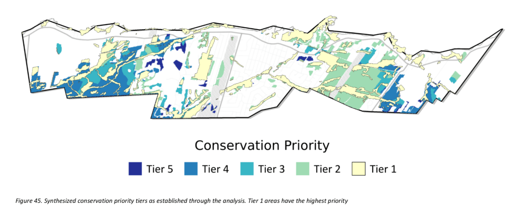
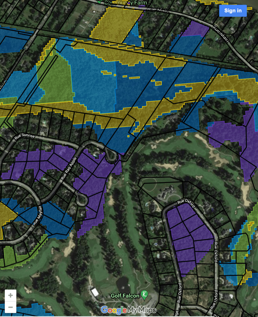
To recap, council adopted the first draft of Bylaw 525.3 at its Dec. 6 council meeting. It also froze the issuance of subdivision requests and building permits on every Hudson lot falling — entirely or in part — within one of five colour-coded tiers contained in a 2020 report by Eco2Urb (now Habitat) ranking conservation priorities. The five, in descending importance: core conservation areas; top 25% conservation priorities; top 30% conservation priorities; Montreal Metropolitan Community and Vaudreuil-Soulanges MRC conservation priorities and lastly, a catchall labelled remaining natural areas.
As you’ll see, three of the five tiers are based not on science, but on hypothetical scenarios and political discussions at two workshops held in the fall of 2019 and attended by fewer than 30 people.
In the spirit of this consultation, here are my three questions and a series of observations:
Q#1: If the 2020 Eco2Urb report is the bedrock on which council’s proposed overhaul of Hudson’s planning program and zoning bylaws is based, what gives this administration the ethical or legal right to extend the current freeze to hundreds of landowners whose properties were never characterized in Eco2Urb’s report? At what point in the process will these restrictions be lifted or made permanent?
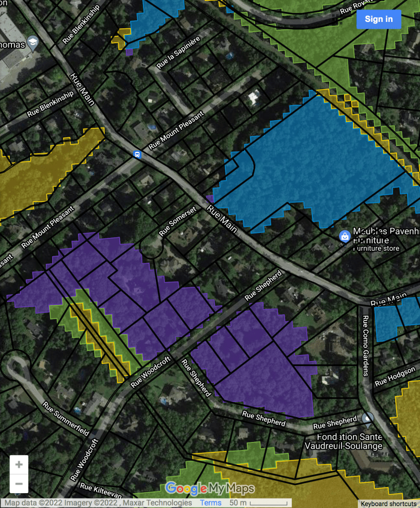
I’m referring to significant differences between Eco2Urb’s five tiers and the town’s interactive version. (The original is posted here, while the town’s version is found on the website or at:
Start with Tier 5: remaining natural areas. We find less than a dozen of these purple blobs on the Eco2Urb overlay, yet they’re scattered throughout the town’s interactive map. For example, the town map draws a swath of purple covering some 18 lots between Shepherd and Mount Pleasant you won’t find on the Eco2Urb map. Purple predominates in parts of Hudson Valleys and Alstonvale. Who authorized these additions? On what basis were they characterized thus?
Q#2: Eco2Urb told those attending the workshops that the town has access to the software to enable property owners to determine by address or cadaster whether their lot is within one of the tiers. If so, why hasn’t this ability been made available to concerned citizens as part of the process?
On the town map, we see all or parts of built lots characterized as Tier 2-5, even on long-developed streets and subdivisions: Bellevue, Seigneurie, Oakridge, Olympic, Whitlock West, Windcrest, Fairhaven, Birch Hill, Upper Whitlock, Evergreen, Mount Pleasant to name a few. Will these characterizations be lifted? When? If not, when will their owners be made aware of the constraints on development?
There is a DIY possibility here. Property owners can find their cadastral numbers on their tax bills. Armed with that knowledge, they can Google Infolot, zoom in on their property, then match it with the lot shape and location on the town’s interactive map. For those without the inclination or time, wouldn’t it be easier to reprogram the interactive map with cadastral numbers?
Q#3: What part of the proposed changes to 525.3 are science-based and what is based on conjecture and politics?
Many residents are asking how the colour-coded five-tier metric evolved. Go back to May 2019, when Eco2Urb was hired to incorporate known wetlands and woodlands in Hudson’s planning program and zoning bylaws. Eco2Urb’s team began with verifying the data contained in the 2008 Teknika greenspace audit and 2017 CIMA+ study, then filled in the gaps with their own fieldwork. With cutting-edge planning spoftware, they generated the biodiversity, landscape connectivity and ecosystem service maps found in their report.
The result of that first pass was Tier 1: Core conservation areas. Canary yellow on the Eco2Urb priorities map, they’re the yellow-edged brown areas on the town’s interactive map. These are areas already enjoying some environmental protection from municipal bylaws and provincial legislation — forested and open wetlands plus a 10-metre buffer zone, watercourses and their buffers, slopes of more than 30 degrees and their buffers, and flood zones along the Ottawa. “These are corridors of high ecological value.” the report concludes. I doubt many residents have a problem with Tier 1.
At this point, Eco2Urb’s mandate strayed from science into scenario-spinning and discussions about how to rank greenspaces in terms of their conservation and ecosystem service values. Facilitators at two workshops oversaw a handful of citizens in a consensus-building process determining what should be saved first. What would be the result if 25% of the top conservation priorities were protected? What about 30%? What happens if we add the conservation priorities of the CMM, the MRC? The result: tiers 2-5.
Tier 2: Top 25% conservation priorities. Pale green on Eco2Urb’s overlay and forest green on the town’s version, this and the Top 30% are arbitrary numbers based on a range of assumptions presented at two workshops for council members and citizens. (The latter saw a turnout of just 26 people.)
The workshops included blue-sky scenarios, some of which had no basis in reality. In an exercise weighing the relative impacts of transit-oriented and service-oriented outcomes, both foresaw “Hudson’s golf courses […] flipped into urban developments resulting in the erasure of Golf Falcon, the Whitlock Golf and Country Club as well as the Como Golf Club.”
In fact, The Falcon and Como Golf are agriculturally zoned under provincial authority (CPTAQ) while repurposing all or any part of Whitlock would require zoning changes at three levels of government (municipal, MRC and MMC).

Or this: “Agricultural land would be lost in part to urban developments in areas previously zoned white.” More than half (52%) of Hudson’s 36.5 square kilometres is zoned green on the CPTAQ map. Neither the Montreal Metropolitan Community nor the Vaudreuil-Soulanges MRC have shown interest in supporting municipal dezoning requests even if Hudson applied — which it hasn’t in the past decade. Nothing supports this hypothesis.
Tier 3: Top 30% Conservation Priorities
Teal on Eco2Urb’s overlay and light blue on the the 525.3 map, the 30% represents what Eco2Urb believed would be the optimal conservation mix. While Eco2Urb’s overlays aren’t high enough resolution to be certain, there are enough discrepancies between the two maps to beg the question why. Were they aimed at stopping specific developments? Were they driven by an anti-development agenda? Those questions need to be asked because you can be sure the lawyers will be asking those same questions when alleged disguised expropriations are litigated.
Tier 4: PMAD and Vaudreuil-Soulanges MRC conservation priorities
Aptly Quebec blue on both maps, these natural areas are defined as high priorities in the master plans of the Montreal Metropolitan Community and MRC. What I find odd is that while Hudson’s business-as-usual data shows a decrease in the total number of hectares developed, Eco2Urb projects significant increases in every scenario. On what basis?
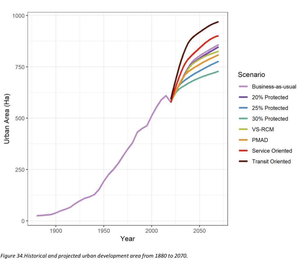
Q#3: One of Eco2Urb’s metrics in establishing the five tiers was what would happen to the town’s greenspaces if development was left to current practices. Their report doesn’t define what is meant by business as usual. The number of households in Hudson increased by 375 between 1991 and 2016 according to federal census stats. Over that period, Hudson averaged 15 new doors a year, or 7% growth over 25 years. Can we assume this is what should be considered as the business-as-usual baseline and if so, what’s the problem with that level of development?
To sum up, this proposed bylaw revision appears to be based in part on hypothetical concerns with little or no scientific basis. I believe most citizens will agree on the need for stronger measures against unnecessary tree-cutting and wetland backfilling on undeveloped land, but this can be achieved through more robust regulation enforcement on a lot-by-lot basis. Hudson’s ravines — and the streams and brooks that run through them — are fragile and prone to contamination from failing septic tanks and other pollution sources but this council has already been made aware of proposed solutions.
I appreciate the enormity of the task this administration has set for itself in attempting to plug every loophole in Hudson’s planning program and zoning bylaws, but that isn’t an excuse for using Eco2Urb as justification for slamming the door on development. That orientation is nowhere in the report and this council will be reminded of that when the inevitable disguised-expropriation lawsuits arrive in civil court.
My advice to the mayor and council: Understand that this isn’t an exercise in proving how environmentally woke you are. Get your head around what this means to all of Hudson’s citizens, not just those who elected you. And above all, listen and take the advice of those who submit their questions, comments and observations. They’ll be the judges of your honesty and transparency.
(For more on how the colour-coded tiers came about, read my previous thousandlashes.ca posts Development vs. conservation: hope for a path forward, Nov. 14, 2019 and Eco2Urb report: plan to protect, July 9, 2020.)