Bylaw 526.8: Sandy Beach sellout to First Nations?

Sandy Beach empty.JPG
The beach represents a fraction of the 22.83 hectares owned by developer Nicanco and remains Nicanco’s property with a servitude for public passage held by the town. What part of Sandy Beach would be signed over to a First Nations community as the result of Mayor Nicholls’s negotiations?

Hudson’s controversial Bylaw 526.8 is not on the order paper for Monday’s December council meeting, but that won’t stop its supporters on council from trying to add it to the agenda.

Those who call this a Trojan Horse may be close to the truth. 

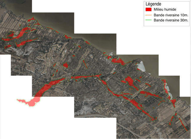
Adopted as a draft bylaw without prior notice at the October council meeting by a 4-2 vote, 526.8 in its original form would have imposed a 30-metre buffer around any part of Hudson designated as a wetland, regardless of size or location.

As originally written, the bylaw would have had a major impact on as much as a quarter of Hudson’s 2,200 residential properties. Owners of hundreds of properties backing on wetlands characterized in the 2008 Teknika HBA and 2016 CIMA+ studies would lose the right to so much as cut their grass except with a push mower. Hudson Yacht Club would have been barred from using their parking lots. Whitlock Golf Club would have lost the use of at least six holes. 

Any request to exclude one’s property would require a biologist’s report and a survey.

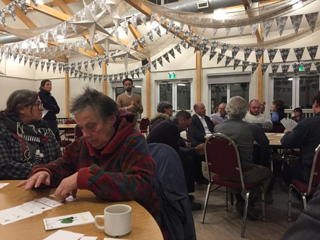
Upon learning of the restrictions to their rights as property owners and the potential impact on the value of their properties as well as on the town’s tax base, residents responded with anger and concern. On Nov. 18, more than 120 people attended a public consultation on the proposed bylaw. 

Note: Public consultations are required by law prior to a zoning bylaw’s final approval but because this bylaw would modify Hudson’s existing zoning bylaw 526, it is not subject to approval by referendum.

Mayor Jamie Nicholls opened the consultation with a lengthy preamble, during which he said council was split 3-3 and that he would break the tie in favour of the bylaw’s adoption. He then inferred that residents who lost the use or value of their properties could be compensated with monies from a $20 million fund run by Ottawa.

Not true, Vaudreuil-Soulanges Liberal MP Peter Schiefke wrote in a text sent late Thursday. 

Schiefke said it came as a surprise to hear from numerous Hudson residents following the consultation that the mayor had told those at the meeting that “20 million dollars of federal funding was secured to purchase private and public lands in Hudson….This is simply not true at the present time,” the MP added.

This past Thursday, the mayor appeared to back off his plans to proceed with final adoption of Bylaw 526.8. “After much discussion with caucus members […] the provisions of the bylaw in article 726 which expanded the protective band surrounding wetlands from 10 to 30 metres have been modified,” he posted on two of his Facebook pages. “The protective band will remain at the original 10 metres in the amended bylaw to be presented at the December session of council.” 

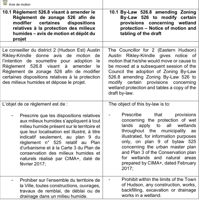
But since then, the mayor and his supporters have been publicly pressuring councillors to adopt an amended Bylaw 526.8 at Monday’s December meeting, specifically Article 725: Constructions, works, backfill or excavation works, dredging or extraction works in a wetland. Art. 725 allows “works intended for a construction, other works including backfill and excavation, dredging and extraction in and enclosed wetland” once it is authorized by the provincial environment ministry. If there is no ministerial certificate of authorization (CA), “only the construction of a bridge or footbridge, on stilts or posts, without backfill” is authorized.

The developers of the Pine Beach project hold a valid CA. Without the 30-metre buffer, Bylaw 526.8 now permits the development of Sandy Beach according to a revised plan submitted by the developer. At the same time, it blocks the 134-door Willowbrook development in Como because developer Habitation Robert is still waiting for a CA.

Given the mayor’s insistence prior to being elected on the need to block Nicanco’s 256-unit Sandy Beach development, what transpired to change his mind?

As the result of email exchanges with the mayor and others, and with facts drawn from publicly available sources, the following scenario has emerged:

In late August, the mayor attended a three-day Union des Municipalités summit in Wendake, Quebec, where leaders of Quebec First Nations met with mayors of Quebec municipalities. The summit highlight was a public apology by Oka mayor Pascal Quevillon to Kanesatake Grand Chief Serge Simon for comments Quevillon made concerning the handover of some 60 acres at the centre of the 1991 Oka Crisis. 

Mayor Nicholls has confirmed in an email that he and Simon spoke and agreed to convene a meeting of the two councils — and that he informed caucus upon his return.

Nicholls band council.jpg
This screenshot was taken from a live video posted Sept. 24 by Hudson mayor Jamie Nicholls outside the Kanesatake Band Council office. The nature of any discussions, and with whom, has not been shared with all council members.

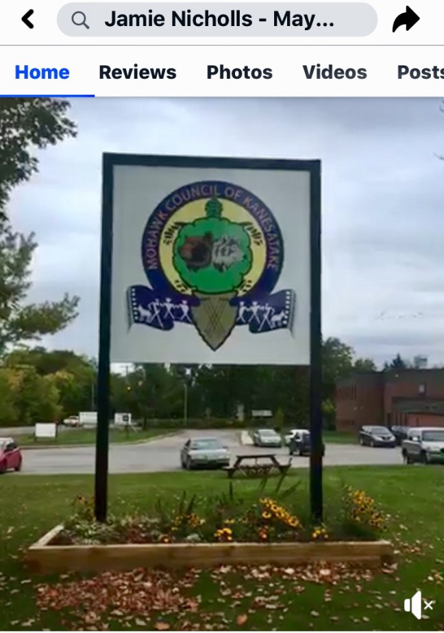
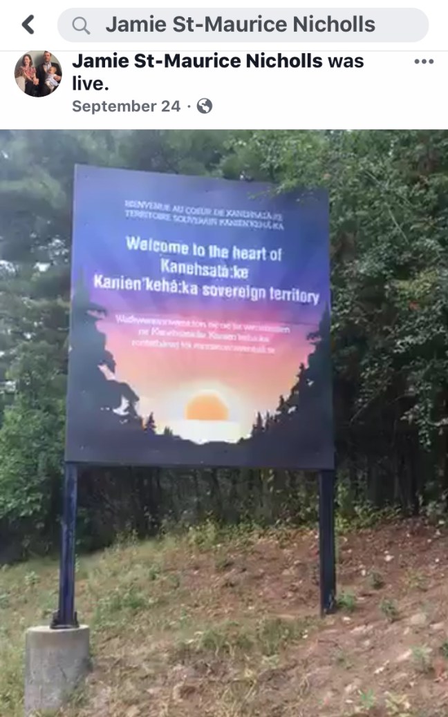
 On Sept 24, the mayor posted a live video to two of his Facebook pages indicating that he was in Kanesatake for a meeting at the band office. The nature of any discussion taking place and with whom wasn’t reported to council. 

Earlier this week, Vaudreuil-Soulanges MP Peter Schiefke confirmed that Nicholls had approached him at a Nov. 21 MRC event to discuss funding options for the purchase of wetlands, including sections of Sandy Beach already protected under the town’s 2017 development agreement with the developers. 

Schiefke says he explained to the mayor that the compensation assurances made to residents at the Nov. 18 public consultation were unfounded. “[…] the fund that Mr. Nicholls referred to at his consultation meeting […] was likely the Disaster Mitigation Fund (DMFA) that was created to reduce the socio-economic, environmental and cultural impacts triggered by natural hazards and extreme weather events in communities at high risk.”

Schiefke says he told the mayor that it is unclear whether the DMFA will be reactivated — and if it does, Hudson residents would be on the hook for 60% of a minimum $20 million project.

Moreover, Schiefke added, the town has yet to take any action to explore the possibility or open a file.

“I shared with Mayor Nicholls that an official exploratory meeting with my office would be beneficial, and that the City of Hudson would subsequently have to submit an official request for funding to Infrastructure Canada when the application process reopens. Neither the meeting, nor the submission has occurred to date.”

Schiefke also confirmed that the mayor had discussed partnering with an indigenous community to raise the federal contribution to 75% as long as the land is deeded to that community. The mayor then explained his vision for a visitor’s centre on Sandy Beach focused on indigenous culture and healing.

In an emailed response, the mayor confirmed that he met with Schiefke “and that I wanted to discuss all options for the conservation of natural infrastructure on our territory. Again, the conversations were exploratory in nature and touched many different areas.”

The next day, Nov. 22, the mayor approached Sandy Beach developer Marc Perreault without a mandate from council to discuss paying financial compensation for land already protected under a 2017 development agreement. Alternately, Nicholls suggested its outright acquisition with monies from a federal program to fund natural infrastructure promotion and protection projects. 

On Saturday, Nov. 23, I called Perreault for his version of events. He had not returned my call by the time I posted this. 

In an emailed response to my questions Wednesday afternoon, the mayor said no promises were made. “It was simply an exploration should the disaster mitigation and adaptation fund be renewed.” 

Nicholls said it was Schiefke who had brought forward the possibility of the $3 billion fund’s renewal. 

“Nothing is set in stone,” the mayor added. “Citizens want us to explore it. Any formal engagement would require a majority of council.”

Schiefke says he reminded the mayor that even if Infrastructure Canada accepts Hudson’s application (See DMAF terms and conditions, below), Hudson’s taxpayers would be on the hook for 25%. Nicholls assured him he had the money.

Nicholls Kanesatake 2.jpg
Once any part of Sandy Beach is deeded to a First Nations community, it becomes their sovereign territory. Who controls access? Who is responsible for security, maintenance and upkeep?

It would be the first time in Canada that a non-indigenous municipality purchases public or private land in order to deed it to a First Nations community. At that point it would no longer be a part of Hudson, but the sovereign territory of the community it is deeded to.

This afternoon, Schiefke said his interest lies in seeking clarity and reiterated his standing offer to the municipalities in his riding. “As has been the case over the last four years, my office is always open to supporting municipalities as they pursue funding opportunities for projects that will benefit our shared citizenry.”

To access more information about the DMFA fund and the criteria involved in the application, please visit: https://www.infrastructure.gc.ca/dmaf-faac/index-eng.html


DMAF terms and conditions ( my highlights are in bold)

Eligible projects under DMAF include:

• New construction of public infrastructure including natural infrastructure; and

• Modification and/or reinforcement including rehabilitation and expansion of existing public infrastructure including natural infrastructure.

Eligible investments aim to reduce the socio-economic, environmental and cultural impacts of natural hazards and extreme weather events when considering current and potential future climate change impacts.

Projects must meet at least one of the national significance criteria, including reducing impacts on:

• critical infrastructure and essential services;

• health and safety of Canadians;

• significant disruptions in economic activity;

• costs of recovery and replacement;

• vulnerable regions.

Projects must have a minimum of $20 million in eligible expenditures.

Eligible expenditures may include design and planning, capital cost, as well as costs related to meeting specific program requirements. Land acquisition is only eligible for natural infrastructure projects and under some conditions.

• Project bundling is allowed for projects including multiple assets that work in a complementary manner to reduce the risk within the same time period.

• Projects must be completed by 2027-28.

Note: Expenditures related to all emergency services infrastructure, relocation of entire communities, land acquisition as a sole project component, are not eligible under DMAF.

Development vs. conservation: hope for a path forward

Screen Shot 2019-11-14 at 12.09.31 PM.png
The map showing how the 10 and 30-metre buffers extend out from Hudson’s identified wetlands. This is a static screen shot of the interactive version supplied to council.  A more detailed map has been promised for Monday’s Bylaw 526.8 public consultation, along with a lot-by-lot overlay showing how individual properties will be impacted. Other than imposing a one-size-fits-all edict on more than 200 properties, this map is next to useless.

I find it unfortunate that the uproar over Bylaw 526.8 is threatening to obscure the potential benefit to Hudson from the data being surfaced by urban planner Eco2Urb.

In June, council approved Eco2Urb’s hiring on the basis of the following conditions:

— It would update and confirm data contained in the 2008 Teknika HBA wetland and woodland audit;

— It would fill in the blanks in the 2016 CIMA+ conservation plan for Hudson’s urban perimeter (the 48% of the town already zoned for development);

— Like Teknika and CIMA+, Eco2Urb would then rank these natural spaces in terms of conservation priorities that could be incorporated in a revised master plan.

Under political pressure from Hudson’s anti-development lobby, council added a fourth ask — that Eco2Urb provide a scientific basis for the tripling of the province’s 10-metre buffer zone around Hudson’s extensive wetlands. 

For $89,367.50 plus taxes, Eco2Urb’s team would apply the same conservation template to Hudson that it had developed for St. Lazare. Roughly $20,000 of that was for workshops where everything would be explained to council and citizens.  

IMG_1957.JPG
Eco2Urb’s Kyle Teixeira-Martins and facilitators brief participants at Monday’s workshop.

Last Monday (Nov. 11) was the public workshop. Leaving out the mayor and five councillors, fewer than two dozen Hudson residents turned out, possibly because of the season’s first blizzard. Whatever the reason, the net result is that residents won’t have the benefit of understanding how and why Hudson should go about protecting its wetlands and woodlands as our region comes under increasing pressure to develop. 

I wonder whether the turnout would have been greater if residents were told Eco2Urb’s data will allow allow a lot-by-lot identification of possible environmental constraints — and that eventually, this information will be available to developers, property owners and real estate agents. (No, Hudson doesn’t need Bylaw 526.8.)

There were three tables. I was at a table with the mayor and several residents of Wilkinson, a street in Como where a number of properties back on the wetland running through the proposed Willowbrook development as well as to the rear of Oakfields. Once they heard their properties could be affected, even those in favour of protecting wetlands and woodlots tended to back off when they realized the resale value of their properties could be affected.

The next table over featured councillors Robinson and Rikley-Krindle, plus members of the mayor’s Environmental Action Group, or as one observer remarked, the NIMBYs (Not In My Back Yard) and the NOPEs (Not on Planet Earth). The third table included councillors Kurgansky and Legault as well as West End property owners.

Eco2Urb’s Kyle Teixeira-Martins  and his facilitators set up the exercise by explaining how they propose to rank Hudson’s wetlands and woodlands according to six ecological yardsticks — resilience, biodiversity, connectivity, forest maturity, flood mitigation and recreational/historical importance. We were then asked to rank the six metrics in order of importance. 

— Resilience is the measure of a natural area’s ability to recover from insect invasion, disease, drought or flooding.

— Biodiversity is the sum of the trees and animals found in a natural area.

— Connectivity is the measure of an area’s attractiveness as a habitat and migration corridor for vertebrate species.

— Forest maturity ranks forests according to their age. A young forest is zero to 40 years, an intermediate forest 40-80 years and mature, 80+. A mix of all ages is the target balance.

— Flood mitigation is the potential of an area to act as a buffer against the impacts of flooding.

— Recreational and historical importance is a natural area’s importance for citizens and visitors, either because it offers recreational possibilities or is of historical interest.

The second exercise asked us to rank six woodlots according to their ecological value as measured by the yardsticks above. Although nothing was identified by name, the sites of the Willowbrook and Sandy Beach developments were included, making dispassionate discussion difficult. 

While the evening was instructive, the best demonstration of the problems we face in ranking conservation areas came from Pyke Court resident Adrian Burke. Burke told the room he wanted no part in ranking forests and wetlands. Instead, he said, the data developed by Eco2Urb can be used to identify environmental constraints on a lot-by-lot basis. 

Later, Burke provided council with a technical explanation of how the GIS software Eco2Urb employs allows urban planners to click on an an interactive map to access information generated by Eco2Urb. Eventually, anyone with access to the database will be able to reference possible constraints to development for that particular lot or sector.   

IMG_1962.JPG
Eco2Urb’s colour-coded ‘heat maps’ rate wetlands and forested areas but don’t satisfy the need for  site-specific evaluation software. However, the data used in their production provides the town with everything required to make informed development choices.

Burke also offered advice on how the town can use Eco2Urb to move forward without the need for politically fraught decisions on rankings, moratoriums and blanket bans:

— Have Eco2Urb supply the colour-coded ‘heat maps’  as well as all the mapping software data in an easily accessible, searchable form;

— Colour-coded maps will be useful and complementary, but only if used with the database. 

— Ask Eco2Urb to train urban planning in their use;

— It is easy to create maps from the Eco2Urb GIS layers that can be opened and explored using GoogleEarth. These maps should be made available online on the city portal for all residents to consult and use.

This was the real benefit of Monday’s workshop. It got everyone thinking past the need for a blanket ban on land use within 100 feet of wetlands. It showed how the town can harness the technology that cost us $100,000 to accomplish what council set out to do. If we don’t seize the opportunity, this council will have failed at one of its core missions.

 Controlling factors

Following Monday’s workshop, I compiled a list of the factors both within and beyond Hudson’s control that will drive development for the foreseeable future. 

I’m sure there are many others that I have missed.

— Planning imposed on us by the Montreal Metropolitan Community and our regional government has frozen the dezoning of agricultural land. Their goal: reduce urban sprawl and concentrate development in sectors already supplied with roads, drinking water, sewers, public transit, schools and businesses. To accomplish this, MMC and MRC bureaucrats have set non-negotiable densification targets for serviced sectors.

— With less and less land available within these urban perimeters, developers are turning to marginal sites on the edges of wetlands and floodplains. Quebec insists on a mandatory 10-metre minimum buffer zone to protect from people landscaping to the edge of their properties, then dumping lawn waste and other detritus into the protected zone.

— 52% of Hudson’s lands are zoned agricultural, but that doesn’t mean they’re immune to human activity that will degrade their ecological value. Owners of agricultural lands can clearcut mature forest except for 10-metre buffers along watercourses and wetlands. They can strip-mine peat bogs. They can drain and backfill wetlands. They can build houses for themselves, family members and employees. 

— Hudson’s lack of control over what goes on upstream. Development in Vaudreuil-Dorion and St. Lazare is already affecting us in the velocity and volume of stormwater making its way into Viviry Creek and its tributaries. Development in Hudson has an even more immediate effect on water quality along our Ottawa River shoreline. 

— Growing pressure on Hudson’s administration from developers to set a clear, coherent development policy. One is Nicanco, the owners of Sandy Beach. The previous administration signed an October 2017 agreement with Nicanco approving their 256-door development; its partners sought clear signals from this council whether we would honour the 2017 development agreement. Willowbrook, the other major development approved by the previous council, asked for and received the town’s support for an application to the environment ministry to construct roads, a bridge and drainage infrastructure. It’s hard to get lawyers to agree on much, but lawyers have agreed that the lack of a clear, coherent development policy will end up costing Hudson considerably in legal expenses. 

— Quebec legislation gives municipalities the right to say no to development, but it’s not that clear-cut. Jurisprudence — the body of legal decisions on the topic — cuts both ways. Changes to municipal legislation adopted this summer have given towns like Hudson added powers over development, including the ability to freeze new projects while their councils decide what direction future development should take.

— The emergence of popular initiatives opposed to generally accepted practices used by developers — clearcutting, draining, backfilling, levelling. Hudson is widely known among developers as a hard place to do business, especially so for multi-unit projects. At present Hudson has no mechanism to reconcile the right to ownership of private property with the rights of those opposed.

— Our vulnerability to changes to the aquifer that supplies Hudson and most of Vaudreuil-Soulanges with drinking water. Blind faith isn’t going to cancel out the cumulative effects of faster runoff, smaller and fewer retention areas on the aquifer’s ability to replenish itself. Sooner or later, there won’t be enough wetland left to capture the precipitation essential to a sustainable water supply.  Joint stewardship is the only path forward, but our MRC refuses to take a leading role. So we must. 

What public participation policy?

Draft 526.8 ADM 04:10:19.png
Screen shot of Councillor Rikley-Krindle’s notice of motion presented at the Oct. 4 council meeting. Next up: Adoption of the draft Bylaw 526.8 (below).

This coming Monday, Nov. 18 at 7 p.m., Hudson residents will be asked for their questions, comments and suggestions concerning Bylaw 526.8. (The numbers and the fact there’s a public consultation tell us it’s a proposed change to Hudson’s zoning bylaw.)

But in the words of Leonard Cohen, everybody knows the dice are loaded.

Draft bylaw 526.8 will directly affect as many as 10% of Hudson’s 2,200 residences and threatens to burden future budgets  with legal fees we haven’t seen since the Prévost administration.

Who will be affected? Council was supplied with a map showing how the 30-metre buffer extends out from the wetlands characterized in the 2008 Teknika audit, but it lacks the precision to allow someone to see exactly where the red line falls on their property. Legally, citizens can demand and receive the original map because it was compiled with publicly available information.

Today I was assured that a modified map and a cadastral overlay should be ready in time for Monday’s consultation so that property owners will be able to see how the bylaw affects them.

There is sufficient data on the the original map to say this: anyone living next to a wetland, no matter how insignificant, will be affected. Anyone whose properties back on Viviry Creek, Pine Lake and the chain of wetlands running from the Vaudreuil-Dorion border to Brookside will be affected. Originally, I estimated that 100 properties might be affected. Since then, I’ve been told the number could be more than double that and that we can’t even put an estimate on the legal costs of pioneering this approach. (So far, we’re the first municipality in Quebec to edict a 30-metre buffer without public consultation.)

By now you’re asking the same question I did — why is the adoption of 526.8 not subject to approval by referendum? I have been told that it is based on Article 113 (16) of the Loi sur l’aménagement et l’urbanisme (LAU), which rules out the registry/referendum process.

In exchange for removing the referendum approval process, the LAU requires Hudson to adopt a public participation process tailored to our local reality. Such a policy should “look to favour the availability of information, consultation and the active participation of citizens in the land use and urban planning process.” 

Here’s the kicker: 

“Once a municipality’s public participation process respects the requirements of the Act […] motions adopted by Council [under this Act] are not subject to approval by referendum.

However, the LAU requires that a municipality looking for a way around referendums must satisfy the following 10 requirements:

— A transparent decisional process;

— Consulting citizens prior to taking a decision;

— Complete, understandable, specific information on what is being decided;

— The right of citizens to influence the decision; 

— The active participation of the mayor and council in the consultation process;  

— Reasonable timelines that allow citizens to grasp what is being proposed;

— Allowing all points of view to be expressed, with a goal of reconciling different interests;

— Rules ensuring that everyone knows the rules on what the consultation can accomplish, who can participate, what constitutes fair comment and how it will be used to modify the project.

— Adoption of a bylaw governing public participation;

— The town’s participation policy MUST be posted on the town website. 

I can’t find a trace of a Hudson public participation policy, either on the town website or in any of the documents made available to council. One could argue that the town, in failing to fulfill the LAU’s terms for public participation, is therefore not entitled to adopt 526.8 without a referendum. 

How about a non-binding plebiscite? The town is within its powers to set up a register where those both for and against this bylaw have the opportunity to say yes or no. Backers of 526.8 claim 650 residents signed a petition in support of a moratorium on wetland development, but we’re hearing from people who insist they never would have signed had they known this bylaw will affect their tax bills, their neighbours and the town’s spending priorities.

Besides, a petition drafted by an unelected anti-development lobby group is’t recognized by the LAU as part of the legal process.

A plebiscite may not be binding on the town, but it would give some credibility to this botched process and provide much-needed balance to this hijacked debate.

So why haven’t citizens heard more about 526.8? Both the notice of motion and draft 526.8 were presented at the October council meeting. (It’s a legal trick allowing citizens no opportunity to ask questions before council votes.) 

At the beginning of the meeting I asked that we defer 526.8’s adoption until council was supplied with a solid scientific basis on which to triple the protection around wetlands. The mayor declared me out of order, which was incorrect. My deferral motion lacked a seconder, so it died.

Council then voted 5-2 to extend the buffer to 100 feet from Quebec’s statutory 10 metres. Daren Legault and I voted no.

Draft 526.8 adopted 04:10:19.png
Adopted in speed and secrecy, 526.8 was the result of intensive lobbying by a small group of Como residents, some of whom seek a permanent freeze on all future development in Hudson. 

The science behind the 300% increase has never been disclosed or discussed. Instead, councillors appear to have agreed to the increase with the understanding that it could be dialled back if there was a problem.

Council was assured the scientific basis for a 30-metre wetland buffer would be supplied by Eco2Urb, a consulting firm specializing in the use of data on technical factors such as resilience, biodiversity, biodiversity, connectivity, flood mitigation and recreational or historical importance. I attended last Monday’s Eco2Urb workshop; the 30-metre buffer never came up in their presentation and nothing I heard supports Bylaw 526.8.

From the outset, council had trouble understanding how all the pieces leading to 526.8 would fit together.

Would Eco2Urb’s data give us better tools with which to shape Hudson’s future development? Some favoured freezing all development until we figured it out. Others supported a partial freeze based on what we already knew from two previous studies. Most saw 526.8 as a temporary measure pending recommendations from Eco2Urb and Axiome (another urban planning firm specializing in the legal aspects of development. 

Eco2Urb was hired in June on the mayor’s recommendation. No invitation for competitive bids was extended to other consulting firms offering similar services. At the time, council was wrestling with ways to protect wetlands and forests of interest identified in a 2008 audit by consultants Teknika HBA. (A 2016 followup by CIMA+ applied only to the urban perimeter, which accounts for less than half of Hudson’s total land area). We all agreed on the need to integrate the results of both reports into our zoning bylaws but disagreed on the best path forward. 

A council concern was how Eco2Urb’s formulaic approach to ranking wetlands and woodlands would serve us in coming up with better ways to defend against Hudson’s known vulnerabilities. Example: the mature forests covering Hudson’s many steep escarpments and ravines have no protection from affluent landowners willing to pay big fines for that million-dollar view. Another example: preventing landowners from backfilling and landscaping to the edges of wetlands and watercourses, wiping out shoreline vegetation that would otherwise mitigate erosion and flooding. 

On June 3, council voted 5-1 to hire Eco2Urb on the basis of their prior knowledge of our region. (The lone standout was District 3 councillor Chloe Hutchison, who felt the Teknika and CIMA+ studies contained the data required; we needed an urban planner/biologist/lawyer combination to incorporate existing data into our bylaws.)

Council approved the more expensive Option 2 ($89,367.50 plus tax) because it included workshops where Eco2Urb could explain their methodology to council and citizens. It was agreed that residents should be made aware of any decision that could conceivably alter real estate values.  

Citizens will get their one kick at the can beginning at 7 p.m. next Monday evening at the Community Centre.

Next: How Eco2Urb’s data makes Bylaw 526.8 redundant.

UPDATE: Hudson’s TOD saga

DSC_7227.JPG
Hudson’s only morning train: without guaranteed passengers, what are the odds of subsidies? Without better service, what are the odds of attracting more passengers, especially once the REM is running?  

On the agenda for Monday’s (Nov. 4/19) Hudson council meeting is Mayor Nicholls’s veto of the anti-TOD resolution adopted by five of six councillors during the October meeting.  The mayor has justified his veto on the grounds that councillors were confused by my resolution seeking Hudsons exclusion from the Montreal Urban Communitys TOD designation.

Since then, I fully expect that the mayor has lobbied hard to convince two or more councillors to change their vote, killing the resolution and opening the door to the Stantec study on how to apply the transport-oriented development (TOD) designation to Hudson’s benefit.

 While I’m not surprised at the mayor’s veto, I’m disappointed that we’ll never know whether the TOD designation was forced on Hudson or whether we had a choice.

Adopted by the previous council after a series of public consultations in the spring and summer of 2017, the TOD designation allowed developers to pump up the size and volume of their projects to meet densification requirements.

 Critics charge that these densification requirements are bogus, the result of flip-flops by both this and the previous council in agreeing to the TOD designation. They argue that the CMMs TOD densification requirements were pure fiction, written to allow an influx of development projects incompatible with Hudson architecture and Hudsons densities.

A close read of the chain of communications  between the Town of Hudson and the Montreal Metropolitan Communitys TOD project office clearly shows the current administrations original intent to obtain funding for an economic study on Hudsons train service. Specifics include:

coming up with concrete measures for the existing Hudson station;

costing out the electification of the existing rail line between Vaudreuil-Dorion and Hudson to attract more riders;

developing densification scenarios to ensure sustainable ridership, including two additional TODS in in the west end and on Bellevue;

 The document, signed by Hudsons former coordinator of project management, grants  and subsidies, was in response to a July 2018 request from an urban planner with the MMC’s TOD project office responsible for handling Hudsons funding application.

Before signing off on Hudson’s funding request, the MMC urbanist wanted a deeper understanding of the project.

 In the case of Hudson, we understand that there are many elements and orientations requiring evaluation (tramway, parking, densification, requalification, train level of service, etc., he noted, adding that it would be helpful if the administration were to prioritize what it sought to accomplish with the study.

 If I understand it well, the tramway study is an important subject. We would like to have a bit more detail on this concept, specifically what leads you to visualize an infrastructure of this type and how it would fit with your three-hubs concept as well as with existing rail infrastructure.

The MMC urbanist also wanted to know why the town wants further analysis of the existing TOD zone, including size, densification requirements, parking management and levels of public transit service.

 Since then, Hudson’s grant request somehow morphed into a study of the downtown core and how to reduce vehicle traffic and parking in favour of active transport — walking and biking — while adding greenspace and common areas. Gone are those original references to  economic aspects of  the TOD, multiple TODs, electrification, tramways and additional trains.

Earlier this fall, the mayor posted on social media his vision of the downtown core transformed into a bike and walking-friendly environment. In his comments at the start of the Oct. 7 council meeting, he painted a picture of an electric tram connecting three TODs with the Vaudreuil transit hub, about how his contacts with the ARTM will be the magic wand to convert the existing train a day each way into an environmentally and economically sustainable electric shuttle to Vaudreuil.

I know where this comes from. One of the books Jamie lent me, Seven Rules for Sustainable Communities by his former professor Patrick M. Condon, includes a chapter on streetcar and tramway developments. Condons case histories come from the West Coasts sprawling suburbs. Like Condons book on design charettes, the problem lies in reconciling a West-Coast design ethos with Quebecs 21st-century realities, including the REM and its eventual push to Vaudreuil. 

 A year ago Nov. 7, the mayor and I attended a Union des Municipalités transit summit in Trois-Rivières. Federal Transport Minister Marc Garneau spoke, as did the heads of CN and VIA Rail and representatives of Quebecs rail freight and passenger tourist industry associations. Quebec Transport Minister François Bonnardel was the lunch keynote speaker. Jamie and I sat with Rigaud Mayor Hans Gruenwald at a table of CMM mayors talking about the REM, about EXO, about ARTM —— but not about trams and electrification of short lines. Their consensus: forget trams and streetcars unless youre a major city. If you can’t guarantee traffic, the funding isnt there for any form of rail.

 Several weeks ago, I met with Vaudreuil-Dorion mayor Guy Pilon, who reiterated his belief that commuter-rail transit, even Hudson’s paltry two trains on weekdays, is disconnected from reality. It will cost $8 to 9 million to bring the EXO right of way up to minimum standards, Pilon said. Adding electrification would mean millions more in major infrastructure — hydro substations, overhead catenaries and light rail transit rolling stock.

Pilon, who sits on the CMM’s public transit committee, also predicts the eventual shutdown of the existing rail line once the REM is extended to Vaudreuil-Dorion. Hudson is missing a golden opportunity to turn the Vaudreuil-Hudson section into a dedicated non-motorized route for cyclists, skiers and pedestrians, he told me.

 After the October council meeting I called the MMC urban planner responsible for piloting Hudsons file through the requirements for the study grant. He told me the anti-TOD resolution put Hudsons funding request on hold until the TOD designation issue is resolved. A meeting scheduled for Oct. 24 was cancelled; the first opportunity for approval is now Nov. 28, when the five MMC executive committee members meet to vote on TOD project grants, including Hudsons.

Mayor Nicholls may succeed in saving the funding for the Stantec study, but what will that accomplish? Reading Stantec’s offer of service, I’m not clear on what it is we’re studying, or to what end. Multiple TODs? Conversion of the existing right of way to support an LRT shuttle between Hudson and Vaudreuil, when the existence of the Vaudreuil terminus itself is far from assured? I need to have things spelled out before I vote for them.

The mayor and I are both active transport advocates, but not just for the downtown core and not to the detriment of those who have no choice but to drive. I live in one of Hudson’s many enclaved neighbourhoods where no safe, direct all-weather walking route exists to downtown Hudson. There are no plans to fix this, which I find unacceptable.

One of the realities one learns as a councillor is to suck up one’s defeat on a file and accept the majority decision. I fault the mayor for failing to practise what he preaches — especially when 30 months ago, he was ripping the former administration for not challenging the TOD. Call me confused.