Witnesses Say Shots Fired at Kanesatake Dispensary
Police claim a man crashed a stolen car into the pot shop but deny any shooting took place.
The Sweet Lodge with windows boarded up on Thursday, November 21, 2024. PHOTO: Éanna Mackey
By Christopher Curtis
Kevin* was working at his desk when he heard the first burst of gunfire.
“It sounded like an automatic weapon, small caliber, just a quick brrrrrap!” said Kevin, who did not want his real name published. “There was a pause and then, a couple seconds later, I heard this bang, bang, bang. Sounded like a different gun this time.
“This guy who lives (nearby), he just lost his dad to cancer. I thought maybe he was just sad, got drunk and fired a few shots to blow off steam. People have guns here, sometimes they do that.
“Not this time, though.”
Four sources in Kanesatake say they heard shots fired outside the Sweet Grass Lodge around 5:30 a.m. Thursday. They say the driver of a black car pulled into the dispensary’s parking lot, slammed down on the accelerator and crashed into the building, destroying its wooden porch.
Police confirmed that a stolen black car did, in fact, ram “a pot shack” near Nelson Rd. in the predawn hours on Thursday, but they categorically deny there was gunfire.
“That could have been the sound of airbags bursting,” a spokesperson for the Sûreté du Québec said. “We’ve reviewed security footage and no shots were fired. The driver got away.” Another police source, who reviewed the footage, said the collision did not appear accidental.
Two sources — including one who drove by the area as it was happening — say an armed man chased the driver away and fired at the car. They claim the driver, who was not Mohawk, rammed his car into the building, pulled out a gun and began firing at the front windows. They say he was surprised by an armed security guard who fired at the driver before he escaped through the parking lot of High Times, a dispensary next to Sweet Grass.
Normand Théoret, who owns the Sweet Grass Lodge, flatly denies this.
“Drunk driver,” he wrote in a message to The Rover. “Why don’t you get a real job and stop spreading rumours and lies like a little bitch.”Support Little Bitches
Théoret is one of 17 people on trial for his alleged role in an illegal dumping scheme that contaminated entire sections of the Mohawk territory.
Though most of his co-defendants are elderly and appear to be minimally involved in the scheme, Théoret’s property was one of the largest dumping sites in Kanesatake. That is, until the practice was shut down by court order last month.
He is accused of accepting contaminated soil on his land, pushing soil directly into the Lake of Two Mountains, and two other violations of provincial law — charges that have not been tested in court. Alongside co-defendants Robert Gabriel and Barry Bonspille, Théoret is one of the few suspects who also happens to be a player in the territory’s lucrative cannabis trade.
The alleged car attack is the latest in a series of violent incidents plaguing Kanesatake’s cannabis industry.
Earlier this year, an arsonist tried to set the Golden Star Oka dispensary on fire with an incendiary device but failed. A police source says it was the third time someone tried to burn down the dispensary, which opened earlier this year on a plot of contaminated land owned by Barry Bonspille.
When asked if these arson attempts were the work of Mohawks or outsiders, one source laughed.
“Did the building burn down? No? Well, then it was outsiders,” he said. “When Mohawks set out to burn a building, the building burns.” 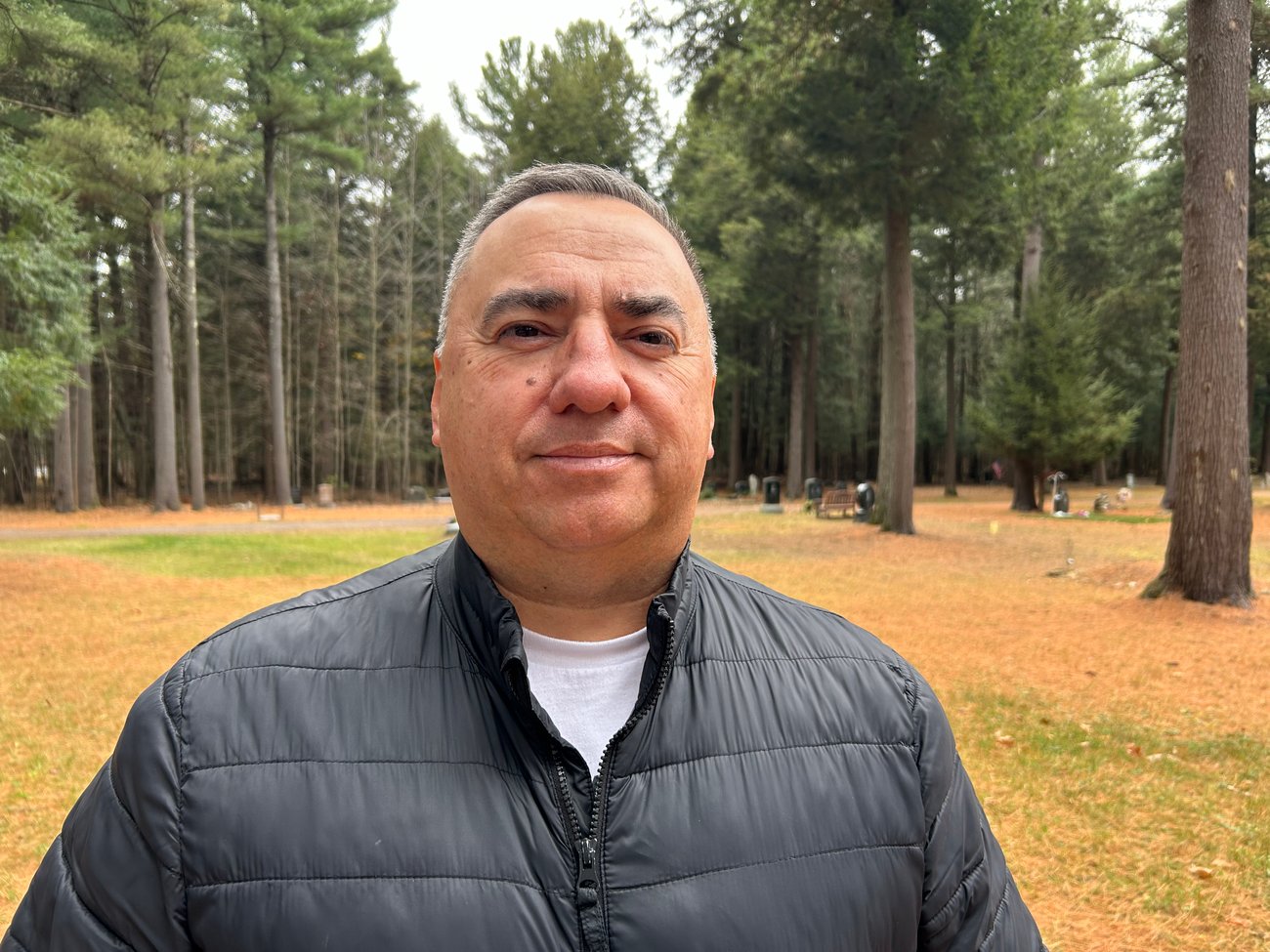
Mohawk Council of Kanesatake Grand Chief Victor Bonspille. PHOTO: Chris Curtis
Mohawk Council of Kanesatake Grand Chief Victor Bonspille said regardless of whether shots were fired during Thursday’s incident, people on the territory are fed up. Since their police force was dissolved in 2004, Kanesatake has been patrolled by a small Sûreté du Québec detachment about five kilometres away in Oka. Bonspille says there’s minimal police presence at night.
“All I know is that an incident happened up the bay, a car was involved and security chased this person off,” said Bonspille. “Just last week I met with the regional chief of police and the SQ’s local chief and just said enough is enough. Just last week a drunk driver hit one of our youth, and the students at our high school say they don’t feel safe.
“I demanded more police presence, whether community members agree to it or not. We need something here. And the SQ has been mandated to patrol our community. I understand they’re afraid to come here at night. But at the very least, they can patrol here during the day and patrol undesirables.”
Both Théoret and the police say they’re certain no shots were fired Thursday. When presented with this, each of the four sources who claimed to have heard gunshots stood by their initial statement.
“Listen, I grew up around guns, I know the difference between an airbag popping and the rattle of gunfire,” said Jane*, who did not want her real name published. “I was getting ready for work and I heard what I heard. It was gun shots followed by a pause and more gunshots.”
Another source said, “I am a licensed gun owner, I know what guns sound like. Those were gunshots.”
Finally, The Rover reviewed security footage from Thursday morning that includes audio of two distinct bursts of gunfire.
“So if all that happened was a car ramming into the porch then why are windows on both sides of the front door smashed? And I ain’t never heard of airbags going off and then going off again seconds later,” Kevin said. “They’re trying to say it was ‘some drunk Black guy’ but that’s not what happened.”
The Rover drove by Sweet Grass on Thursday and inspected the damage. While the wooden steps at the front of the building were clearly broken, the remainder of the porch, bannister and front door did not appear damaged. But the large windows on either side of the stairs were boarded up.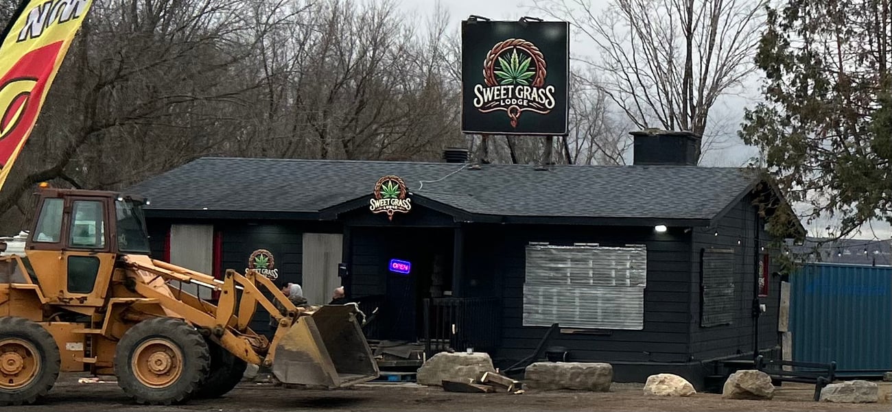
The Sweet Grass Lodge with windows boarded up and apparent damage to the wooden stairway leading to the entrance, on Thursday, November 21, 2024. PHOTO: Chris Curtis
If the theory is that the impact of the car against the building — and not bullets — that smashed three windows, there’s little other damage to the storefront.
Unlike some of the more problematic dispensaries, Sweet Grass is in a small aluminum shack and doesn’t incentivize customers to stay and hang out.
At places like High Times — which police say belongs to Robert Gabriel — buying cannabis is just one in a litany of pleasures one can enjoy.
During a walk through the dispensary Thursday, non-Indigenous vendors were seen selling pre-rolled joints, magic mushrooms and THC-infused desserts as people walked around smoking pot in the store. At the back of the room, a large man sat by the bar and kept watch over the front door, occasionally glancing up at a 10-foot television screen projecting hockey highlights.
Over a dozen sources on the territory say alcohol is served 24 hours a day at High Times. Alongside the Green Room — owned by Robert’s brother Gary — it attracts people with connections to organized crime, according to police. One patron stumbled out of the bar a few months ago and drove his Mercedes into a steel pole along Route 344, narrowly missing someone’s home.
Last week, a drunk driver crashed his pickup truck into a Mohawk family’s vehicle. The driver was arrested and the family taken to the hospital. Residents took his truck, which police had left by the road, smashed it beyond recognition and spray painted the words “enough is enough” onto it. They then planted two Mohawk flags in the vehicle and dragged it to the band council office to protest inaction against the criminals using their land as a playground.
The first cannabis shops opened in Kanesatake just months before the substance was legalized across Canada in 2018. Initially pitched as medicinal cannabis dispensaries, the first shops were family-owned businesses that tried to establish a self-regulating industry on Mohawk land. They even partnered with an Indigenous laboratory to test each gram of cannabis for contaminants.
That year, they reached out to Serge “Otsi” Simon — who was grand chief at the time — and asked for the band council to work with dispensaries and draft regulations to keep gangsters out of the business. Though Simon was adamant that the industry would lead to the sale of hard drugs in Kanesatake, his council did not take action to oversee the industry.
Within months of the first dispensaries opening, some of Kanesatake’s less scrupulous residents partnered with outsiders to turn cannabis into a regional attraction. At the Green Room, opened in late 2018, customers could buy alcohol, gamble on slot machines, get a haircut and eat fast food.
It was during a raucous Green Room party that Montreal gang leader Arsène Mompoint was shot to death on July 1, 2021. Witnesses say the shooter then got into a truck, cut across the pine forest and escaped Kanesatake through the back roads. Police later found the stolen car torched in a cornfield a few kilometres away, suggesting this was a professional hit.
Sources say Gary Gabriel, who was sitting next to Mompoint when the gangster was murdered, was summoned to a community meeting where other dispensary owners berated him. At the time, they tried to get Gabriel to stop serving liquor and attracting outsiders who would linger on the territory, often under the influence of drugs and alcohol.
Instead, Gabriel expanded the Green Room even more, hosting bigger parties, mixed martial arts events and drawing huge crowds into a community of just 2,000 residents. The expansion fueled a sort of cannabis arms race, where rival dispensaries got bigger and bigger, gradually pushing the family-owned shops to the margins.
It may have been this push for bigger attractions that led to the dumping scheme, according to police and Mohawk sources. The contaminated soil was brought into the territory from outside construction companies, dumped directly into the lake, flattened by steamrollers and paved over to make new cannabis shops like Golden Star Oka, High Times and Sweet Grass.
So far, at least two of those dispensaries have come under attack.
Sources say these are generally business disputes where owners hire an outsider to vandalize or burn down their rival’s shop to put them out of business. Others have tried slashing their cannabis prices as low as $40 an ounce to draw customers away from their competitors. Three years ago, one dispensary had Hells Angels hang out on their front porch — in full biker regalia — to scare off potential vandals.
Given the violent nature of these incidents, residents of Kanesatake are hesitant to speak out publicly. Even Grand Chief Bonspille was warned, by loved ones, not to come forward for fear that it would put a target on his back.
“I have no choice but to speak out, there’s kids and elders at risk,” Bonspille said. “We need our own police force, we need the federal government to get serious about solutions here.”
Indigenous Services Canada was not immediately available for comment, but negotiations over restarting a local police program have been ongoing for at least four years. Given the possibility for conflicts of interest in such a small community, creating a police force that’s impartial, effective and consistent with Indigenous values has been challenging.
“Something’s going to have to change,” Bonspille said. “I have young women, teenagers, complaining about outsiders coming onto the territory and propositioning them. What’s it going to take for the SQ to do their job?”
With files from Éanna Mackey.
Did you appreciate reading this article? Share it with a friend!
The Rover prides itself for reporting without corporate owners or asset-stripping hedge funds. We exist to serve you, our readers. As a reader-supported publication, you are our stakeholders and the people we’re accountable to.
So if you believe in our mission and can get behind it, consider becoming a monthly donor today. Every dollar goes towards building a better informed Montreal.Support The Rover
More From The Rover
Most defendants so far have been small players or victims themselves, but investigators say they’re pursuing criminal charges against construction companies.
By Christopher Curtis
Expert says this may be a violation of provincial law.
By Isaac Peltz
This email was sent to duffcraig48@gmail.combecause you opted into The Rover’s newsletter.
Want to change how you hear from The Rover? Update your preferences or unsubscribe here.
Christopher Curtis, 3565 Decarie Boulevard, Montreal, QC H4A3J4, Canada