longer be rebuildable or insurable — but it does not include the slice of Sandy Beach adjacent to Beach Road.
Shocking news in this morning’s La Presse: thousands of Quebec residents have 24 hours to learn whether their homes are included in the government’s latest government floodplain maps.
“Their houses will be worth nothing,” a clearly perturbed Vaudreuil-Dorion mayor Guy Pilon tells La Presse’s team. Almost 2,000 homes in Pilon’s city are included in the environment ministry’s revised charts. Schools, seniors residences and the city’s water filtration and wastewater treatment facilities are included in Quebec’s new 350-year flood zones.
What’s especially disturbing is how Environment Minister Benoît Charette unveiled the changes in June without releasing the interactive website geoinondations.gouv.qc.ca which allows every municipality and residents to see for themselves who will be affected before the end of the public consultation process.
That process runs out on Thursday, Oct. 17, 2024 — tomorrow.
The Montreal Metropolitan Community, which represents 82 Greater Montreal cities and towns, put together their own interactive map showing who in the MMC would be affected, but appears to have done little to alert member municipalities of the extent of the impact on their residents.
For the average resident, neither interactive map is user friendly. However, the geoinondations.gouv.qc.ca application includes civic addresses, which allows the user to get a feel for the number of people whose lives will be impacted — and to see who’s in the new red zone.
Hudson hit hard
The Town of Hudson risks losing several hundred millions in property values, depending on whether the structures affected can be insured, mortgaged or sold. Given the disproportionate worth of lakefront properties, the town’s $2.2 billion valuation roll will almost certainly take a hit.
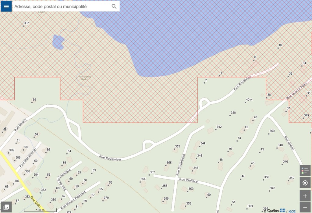
Starting with 896 Main at the foot of Montée Lavigne, some 250 properties fall either partly or totally within Quebec’s new red zone. All but a handful were untouched by the 2017 and 2019 floods. They include mansions (the multimillion-dollar structure at 814 Main falls partly into the red zone) and cottages as well as most of the town’s sewage treatment facilities, the Hudson/Oka ferry and landmarks like the Hudson Yacht Club, Willow Inn, Greenwood and sections of Main Road itself.
Entire neighbourhoods may lose the right to build, rebuild or be compensated for future losses, including Hodgsonville and all but two homes on Quarry Point. While structures of the south side of Main Road are generally spared, the red zone reaches far inland along wetlands in the east and west ends.
Ultimate irony: most of Sandy Beach along Beach Road is on high ground, well above the new high-water mark.
Climate change
Why is François Legault’s CAQ government resorting to these draconian measures? Quebec hopes to avoid having to compensate residents and municipalities for damages incurred as the result of rapidly changing climatic conditions. The torrential rains from Hurricane Debbie were a wakeup call for municipalities far from major bodies of water and resulted in cities and towns rushing to revise their urban planning bylaws in response to pressure from the insurance industry.